|
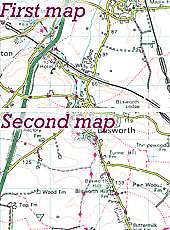
The Mapping of Medieval Detail
|
|
|
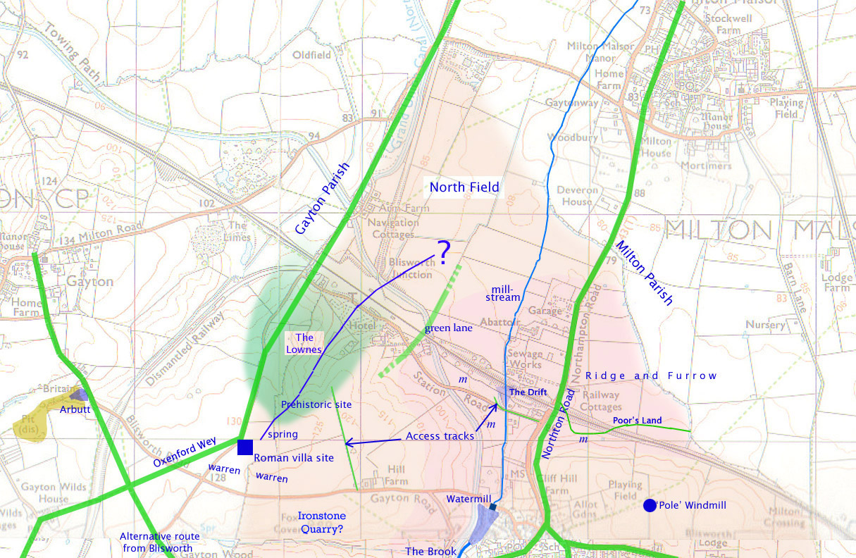
North Field The extent of the feudal North Field is shown in peach/pink colour. From 1940s aerial photographs taken by the RAF there was much evidence of ridge & furrow patterning, the extent of the more obvious being the area shaded pink rather than peach which in fact extends into Milton Parish a little further than Barn Lane. It is not clear where, in the west, North Field gives way to Wood Field and, as there is no evidence of ridge and furrow patterning in the south-east, it may be that those higher lands were used for stock rather than strip cultivation ie. were always inclosed. Mill-stream The stream runs across a slowly descending plain towards Lady Bridge, skirting the sand bank on which Milton Malsor (Middle Town) is perched. This stream was Blisworth's open sewer until replaced by a culvert in the 1920s. Ridge & Furrow patterning show that many peasant farmers had the benefit of a stream at one end of some of their strips and in a 18C Court & Leet memo, farmers are instructed to keep their length of mill-stream clear for the stream flow. This would have applied only to strips north of the Drift in 18C as that was still not inclosed. The Drift This feature is marked on only one map drawn by the railway surveyors. It represents where the line of the stream became ill defined and where rubbish carried by the stream would be inclined to come to rest. Railway engineers in the 1830s circumscribed the drift area with two fresh channels and two 30" culverts which passed under the railway embankment. The western culvert is still used by the stream while the eastern one has been appropriated for sewage. In pre-inclosure times (before 1649 or maybe a very much earlier date) the mill-stream would have cut a steady descent and there would have been no drift. Once the fields in the first inclosure were establish, the farmers would have cut the course for the stream deeper in order to fence with efficiency at its banks. Consequently, on emergence of the stream from the inclosed area, the stream would have attained a level that was too low for its surroundings and the speed of the water would have decreased markedly and, over the years, would have created the drift. Green Lane Discussed in more detail in a separate document, discovered rather belatedly (March 2013) displayed in the map dealing with the tunnel and toll road over Blisworth Hill that has been posted on this website since Nov 2006. The Lownes There are various spellings: Lound, Lownde, Loune. the first of these has been identified as of Old Norse origin and means Grove whilst in 20C Yorkshire dialect (Viking related possibly) the word means Calm. Fields on both sides of the parish boundary with Gayton have Lownde names and the whole area includes a rather remote and miniature valley fed by a spring. It is tempting to regard the area, along with the rising land up to the site of the Roman Villa, as that of a settlement in pre-medieval times (no historic evidence of deserted dwellings have been found) and there is certainly crop and soil marks suggestive of pre-historic occupation. The more northern part is now occupied by an area called Blisworth Park containing modest housing that replaced 'mobile homes' in the 1970s, which in turn took up an area created as Pleasure Gardens in 1845. Ridge and Furrow Comments are made under 'North Field' and 'Mill-stream' above. There are a few un-ploughed grass fields that still bear strong ridge and furrow patterning. These, in the vicinity of the Northton Road, are marked with a lower-case m. Arbutt It is on Bryant's 1827 map that the Gayton Road from Blisworth and the pond are given the name 'Arbutt' and no-one seems to know why. One theory is that there was an ironstone quarry there, approximate extent is marked, from medieval times and that it had become worked out to leave a distinct hollow at its eastern end, where the level of the land falls away. It is presumed that when the road was made up a few times in order to make navigation easier through the edge of a pond, that said pond then became a permanent feature, deep enough to swallow certain motorcyclists. Prehistoric Site The crop and soilmarks are dealt with on the Lowndes page and also in the archeology review map. Ironstone Quarry As discussed in the Mining Article, there is a distinct possibility that this rough remaining hollow, "Fox Covert" on the maps since 1825, in the hillside was an ironstone quarry. Many of the oldest houses in the village are laid on a substantial wall plate of ironstone. The curate reports a known quarry in 1718 offering a good red stone. Ironstone was not recognised as a source of iron until the mid-1800s. Northton Road As a track, this route is doubtless ancient. There is evidence from the lines of double hedging that the line once used to climb higher onto the robust ironstone, coming from Northampton, rather than become bogged in the grey clay substrate at lower levels. The broad grass sides to the east of the road, north of the railway bridge, are labelled in 1727 as 'Cottage's Lands' which is supposed to mean that it was the location of a baulk at the ends of peasants' strips (but why was the baulk so wide?). Poor's land There is another baulk labelled in the 1727 mapping that was for the poor. It is presumed that rent-free peasant strips radiated from both sides of this land. Such feature could have been in existence before the 1650 inclosure of this area but by 1727 the allocation for the poor was within inclosed fields. The line of the baulk is later followed by a field boundary in c1830, on an agent's portable pocket map, and there is no reference there to any area that was free of rent. In any event the coming of the railway in 1834 - 1838, with the need for a wide swath of land for an embankment, spelt an end to the area. Could this have been the trigger that caused the Duke of Grafton to set up allotments in a field adjacent to the Stoke Road? Spring The higher levels had an ironstone substrate and the draining of these types of strata give rise to springs in many places in the parish. Not only has the area suffered from the mining of this ironstone but a bypass for the A43 highway required a cutting and this has resulted in the removal of the entire Roman site and any source for the spring. Access tracks The western track was named Lowndes Lane. Being dead straight might suggest that it is of 19C in origin but in fact it is shown in the 1727 mapping, as shown in the first map on this page. The other was known as Ford Lane in 19C/20C (altered to Station Road after 1850) and must have been an important medieval access. It was a track that is shown in 1727 withering as it entered the first field after fording the mill-stream. The remaining un-inclosed lands (after 1660, mapped in 1727) are in fact only accessible from the village using Ford Lane, hence its importance and indeed its raison-être (for an explanation please refer to a more detailed account). Also, at a much earlier time, before the inclosures of 1649, there must have been a main access track from the village which descended Chapel Lane (then Mill Lane). This can be surmised from the fact that a "Little Ease" (a stocks or a box) was located at the top of the steepest part - a great place to illustrate to peasant farmers what punishments were 'available'. Oxenford Wey The section of route for Oxenford Wey, shown traversing from the Roman Villa site across to the Gayton Wilds (or to "Snakemore"), is entirely the supposition of this author. It seems to fit well but as yet there is no evidence for it! An account of many of the local routes is also available from the same link. Roman Villa Site The site was discovered in 1840. The remains of a Roman corn dryer was unearthed when the bypass was constructed. Warrens Interestingly there are warrens marked on 19C field maps for both Gayton and Blisworth parishes. There is no further information on the dating of this warren area other than to observe that it is likely at some time pre-15C when ownerships of both parishes was the King. Watermill The watermill was an overshot type, presumably with headrace boards that could be adjusted for a wide range of pond levels. Sufficient water for mill was available probably only in winter (Winter brook was a name used in 19C) and so a combination of water- and wind-milling was almost certainly used at Blisworth. Please see the review on Milling. Pole Windmill Of an indeterminate age, the windmill is shown on the 1727 mapping and was thought to be used by Elizabeth Campion and the Westleys in the early 19C before being abandoned in the late 1800s, see some details re. the end of its use. In this area, specifically at what was known as Dinscote near Pattishall, windmills were know as far back as 1298. Please see the review on Milling. |
|
|
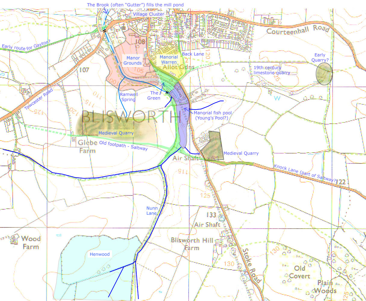
The Brook Current name is Fisher Brook for the stream as it pours into the Canal near the tunnel mouth. 'Fisher' is a corruption of fishweir, being a name associated with a probable fish pool - see the account on the Manorial Fish-pool below. The exact line of the brook as it descends from the fish-pool is not known but it seems reasonable to expect it followed the line of the canal. The extension towards Milton Malsor is named Washbrook. There is a discussion of the water table with regard to the recent spell when it dried out. Mention of the brook is made in the history of milling. Village Cluster The medieval village extended south as far as the Green (at which point the tracks degenerated into diverse green lanes) on what was called South Street (now Stoke Road after 1800 when it was extended south by 2 miles). The main street was defined by a few cottages on the Northton Road (Northampton Road) through to the bridge over the brook (probably Bridge Street but now is the Hish Street). There were a few cottages to the north of Bridge Street, along Mill Lane (is now Chapel Lane). Early route for Gayton? The logic in terms of a route is more apparent overall (please select the map on that page) in having an even grade as well as being directly aimed towards the area known as Britain in Gayton where it crossed a deep gouge due to water run-off and quarrying (so it is believed). The name of the path out of the village was Dingley Lane, named probably after a 17th century tenant farmer. The bridge over the brook in Blisworth was very likely, at one time, augmented by a ford across the brook. This is evident from the alignment of the paths, the pronounced low level in the present Gayton Road (near the parking gate) and the curious sharp kink in Bridge Street (before it was straightened out c1960). In the flash flood of 1992 the two paths, both old and recent, as drawn in the map, turned to streams that directly poured into the canal. Manor Grounds The pink area is merely suggested as a likely confinement, particularly on the north and east sides. A Victorian name for the area was 'The Park'. Aerial pictures from 1947 show a continuity in field boundaries prior to the construction of the canal. Manorial Warren That Wake was granted a manorial warren in 1315 is documented in the Bridge's History and its existence was referred to in 1718. The field name here is Coneygar Leys. Near the Gayton Road, where it crosses into Gayton parish there are fields named 'Warren', in both parishes. Back Lane A well established trackway which served the back access to a number of strips, some freeheld, associated with houses on South Street. The Northampton Road plus (i). the first section of the Courteenhall Road, (ii). Back Lane and (iii). the Nunn Lane taken all together make a reasonably direct route running north-south with a continuation suspected to reach as far as Alderton. There is an article that deals with some of this route as a historical walk to Stoke Bruerne. 19th century Limestone Quarry Documented as being opened in 1810 - 1820 so not relevant to the medieval village. Early Quarry? Documented in Bryant's map (1827) as lime pit and in the awards (1808) as one of two locations for stone for local road repairing. A possible medieval quarry. Towcester Road A road that was established by Roman times although its route was at considerable variance from the current line of the road to the Roman town of Towcester. It was called Westbridge Hill c1841. Ramwell Spring Documented as a notable spring in 1718 which is where we first hear of its name. It is clear that it drained the medieval quarry to its immediate south-west and probably emanated from the limestone strata before the quarry was first opened up. At present, the spring becomes visible as it enters what is currently called 'The Park'. In the field, further up, there are presumably drains to keep the surface dry. However a darker soil colour marks out the track of a once verdant stream emanating somewhere near the edge of the quarry. There were bits of 19th century pottery in that stream, being an indication of villagers' picnics. There was a fresh water reservoir tank near the quarry c1890 which served Grafton House (Westley bros. in occupation) well before mains water came to the village in 1953. The Green It is assumed that this triangular common land patch was called "The Green" in medieval times. The name of the location of the two cottages bordering the allotment gardens (formerly the warren) has been "the Green" in Victorian times. We assume the name was adopted many hundreds of years before then. Other names that have appeared are "Goose Green" and "South-Gutter Green". The green was lost in 1796; excavated entirely in order to gain a tunnel access at 90 metres above sea-level for the canal on its way to Stoke Bruerne. A kink in the outline of the land at the western corner is interpreted as the point through which the brook, as the fish-pool overflow, passes into the field and thence into the Manor grounds. Manorial
Fish-pool A pool known as
Young's Pool c1705 as distinct from the millpond is documented. The
field name is Fishweir Close (1727). The lie of the land clearly was quite low
and some of it has flooded occasionally. Some other parts have been
filled with old bricks from canal tunnel repairs (see previous hot-link)
and there was once a
traverse by a horse railway that was built on an embankment of
earth. The pool was drained by 1727(obviously) and there is
interestingly two little paddock fields along the north boundary of 'Fishweir
field' assigned to separate tenants. These paddocks have an uneven
outline and for that reason they are both assumed to be once beneath the
fish-pool. Believe it or not, to a substantial extent, the drained
fields that were once a fish-pool have been excavated away for the
canal, along with most of the area of the Green. Medieval Quarry There are two quarries, the larger of which was first observed by both the current farmer and by a villager who took a air-balloon flight over the village. The smaller quarry was discovered in some RAF 1945 aerial survey photographs. The 1727 map names the field for the larger quarry as "Slatpitt Furlong" and this implies the stone was best used for slating and not for building freestone. The featuring, particularly evident in the larger quarry, is revealed by crop and stone markings. It suggests the manual manner in which the stone was gained as well as showing that the quarrymen knew how to keep the inroads well drained. Some Roman remains just to the north of the larger quarry indicate a possible farmstead in the area. The present day undulations in level, which run with the crop-marking, is typically of up to 3 foot amplitude (see previous hot-link) - one wonders how deep were the original gullies. Similar patterns are visible just to the north of Stoke Goldington. Saltway
First brought to our attention by a writer to the website (2006) from
knowledge of a 'ramblers society project', the Saltway extends from the
Droitwich area in the west and continues east by a possible
three routes that all initially use
the Knock Lane alignment. Two routes appear to join the earlier
discovered network of Roman routes whilst a third may well run through the Salcey forest
and continue to the east. Village historians in Stoke Goldington
and in Olney have been contacted with no success regarding its
continuation. The 'Saltway' is documented by the curate in
Blisworth in 1718 although he was not explicit. When the 100 acres surrounding Glebe Farm was
assigned to the Church, c1780 - 1808, we can surmise that the footpath
just to the south, following a tributary of the Brook, was preferred and
pressed into
service. Nunn Lane All villagers know of Nunn Lane. It extends south to Nunn Wood which is a good bluebell venue. In c1155 there was established a Priory at Showsley (was Sewardsley) just south of Nunn Wood (off this map) and according to the research report (forward linked from there) the nuns from there were know to the Lord of the Manor (Thomas Wake) as early as in 1470. The green trackway also is likely to have been a significant route that headed due south from Northampton extending to Watling Street in the region of Paulespury with the fortified 'station' at Alderton presiding over the river crossing. The passage of a north-south route from Blisworth parish to Shutlanger parish is recorded as a 'cross' in 1718. Henwood Parish of Easton-Neston field map indicates this field was named 'Henwood'. Its uneven outline suggests it was a wood and the name implies a wood associated with a substantial household (Ekwall even mentions a nunnery!). It is not unreasonable to ring Henwood and Nunn Wood, also Burn Wood nearby as woodland associated with the priory. The sharply polygonal fields nearby were shaped at the time of the inclosures probably as late as 1808.
|