|
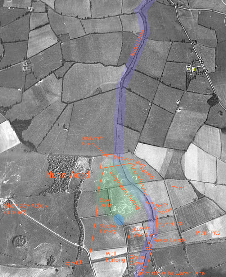
Nunn Lane - to Alderton The map below is an RAF aerial photo taken in 1946 (source: 2010 current Google Earth) which shows fields to the west of Nunn Wood with many hedges that have now been removed. The course of Nunn Lane is familiar but was enclosed by hedges on both sides further south than in recent times. At the point where the lane reaches the first Shutlanger field, it is clear from the location of an ongoing field hedge that the lane continued in a straight line and formed a cross trackway over the path that links Tiffield with Stoke Bruerne (which passes by the north edge of Nunn Wood). Further hedges outline the smooth curve that the lane must have taken before continuing down the gentle slope to the main street of Shutlanger where it aligned with the end of Water Lane. Water Lane, of course, extends past Georgian farm buildings and crosses the Tove and emerges at the northern point of the Green in Alderton. It is therefore easy to "see", with little probability of contradiction, that Nunn Lane was once part of a trackway extending all the way from the Courteenhall Rd corner (current RD2 designation) to Alderton Green. Such trackway provides the most convincing medieval, indeed also prehistoric, route to the south that also would take in Stoke Bruerne via a green side lane. David Blagrove (Stoke Bruerne) has pointed out that the route would have had a special significance in the 9th, 10th and 11th centuries as it crossed the Danelaw-Saxon border at the river and offered a route for trading between the regions. Interestingly, Shutlanger is not mentioned in Domesday so, presumably, the "control-point" for the route would have been at Alderton. The 1932 school map and the 1727 Grafton Survey map give some field names which are inserted in red. The north-most field had neither a name nor dividing hedges in 1932. The "living memory" source of Blisworth can therefore hardly be expected to perceive that the Nunn Lane proceeded straight to Shutlanger. Field boundaries that are given in red are from the 1727 map and they show that Nunn Lane was not continued in any obvious way at that time. There are however, many instances of 10 to 20 metre "dog-legging" which indicate the position of an ancient trackway and, most mysteriously, the eastern boundary of Long Stocking is shown as a zig-zagged line (also in a 1768 map). This is most unusual but the most likely interpretation is that it is a literal representation of a boundary, rather than vagueness for an indistinct boundary as the 18th century mapper used other ways for conveying that. Perhaps the boundary is a series of wood-cock nets (see cock-shot) or rabbit traps with net tunnels at the apexes. The land there would be well-drained, ideal for a "wild" warren that might be easily purged of rabbits using ferrets while beaters would drive the rabbits into the nets. An alternative could relate to early archery-hunting for boar or deer temporarily trapped in the re-entrant netting, unable to outrun a good aim. Interesting is the nearby OE place-name Shittlehangar (Shutlanger) that recalls a wooded slope ideal for spars suitable as arrows. Both Royal and, later, Grafton hunting groups could have spent time at this location. The reason for the curved line in the 1946 boundary may have been because a straight path would take travellers too close to a low lying area near the stream which follows the hedge line on the west side of the trackway. Since 2003 the farmer has created a large lake (shown in blue) on the line of the stream. The curved line also seems to avoid the unusual field marks in Long Stocking field. The markings are perfectly clear in a copy of the photo without enhancement and might be caused by limestone either in terms of outcrops, manual quarrying or walling. The field marks seem to avoid the hedges, a more rational statement, and this could be interpreted as evidence that the marks were created after the hedges and are therefore unlikely to be similar to the prehistoric circular markings on Gayton Hill, not far from The Lowndes. Note that with names such as Stubbs, Stocking and Thrif, it is clear that the area was once wooded. It appears that the entirety of the strange field markings are within Long Stocking - once a wood, so perhaps the limestone was used in some way in the making of charcoal. The origin seems less of a puzzle after talking to a farmer familiar with the area from the 1940s - see below. The name of the 3 acre field called Hitchcraft Piece generates some speculation; rather than witchcraft though lets settle for a "hurdle-making place". Note the spelling of Blithworth Ditch Furlong. No other source as late as 1727 has given the name of our village or fields with that spelling. Note that Nunn Wood, in 1946, had no trees planted in its eastern half. Indeed, part of that area looks as though men with a motor cyclist hobby might have "carved up" the ground. However, the culprits were Canadians with their tanks in 1944. The farmer mentioned above says they fairly terrorised the Shutlanger area, driving through fences and hedges, shooting up equipment such as a farmer's saw-bench. Live ammunition that might damage the tanks wasn't used so "minefields" were laid out using house bricks - any depressed into the earth were scored against the particular tank. Once a week, a staff sergeant would come round taking notes of damages to be compensated. This military exercise history, combined with the apparent freshness of the field marks might indicate that some were trenches, "bunkers" or gun positions for soldiers not lucky enough to be driving tanks. Tony Marsh January 2011 |
|