|
The Lounds Fields , Blisworth, Northamptonshire, UK. All pictures are presented at relatively low resolution. In some cases the pictures are not available due to copyright restrictions. However, permission has been obtained, where possible, to include them here. Printed below each image is the photographer's name, if known. |
|
|
The house presently known as "The Loundes" is pictured below. It was built by Richard Dunkley in 1848 for his family. The name of the house has changed back and forth between this name and "The Lowndes". The actual name given to the house when first built is not know at present. The chart showing the name changes can be seen here. |
|
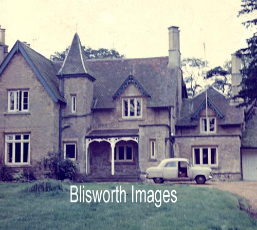 |
Richard Dunkley became a well known architect and builder in Northamptonshire and later in London. He built the Railway Arch in c. 1835 and tended to build public houses such as schools and chapels. Located in Station Road next door to the Blisworth Hotel (currently called The Walnut Tree) it was given its name from the name of the field on which the hotel stands - Northward Lowne or Nether Lowne also known at about the same time as Lownds. Incidently, Dunkley also built the hotel for Thomas Shaw in about 1844. The owners of the hotel in the following years made use of the rest of Nether Lowne for ornamental gardens - later still for a swimming pool known as Blisworth Lido. The aerial picture below indicates the location of the house, looking north. The large field to the west was Nether Lowne and at the time of the picture, c 1960, the gardens and pool had given way to a 'mobile home' park which has since about 1975 adopted permanent pre-fab type housing. |
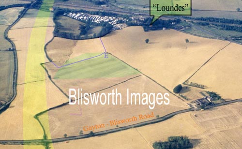 |
Part of Nether Lowne remains as a grass field which can be seen just south of the park. Another field associated with nether Lowne is Upper Lowne and that is outlined in blue on the map. There is a pronounced glacial melt-water groove crossing both fields which ensures that the fields are well drained. A large pond, surrounded by mature trees, is situated across the middle of Nether Lowne. Until a culvert was installed, c. 1975, under the homes park there were irritating flash floods there. In this picture, the broad yellow band indicates roughly the path of the A43, Blisworth bypass. |
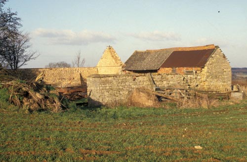 |
In this picture the barn that was known as
Loundes barn is shown before it was demolished in the 1980s. It
was frequently painted by artist Peter Newcombe. In the aerial
shot above it can be seen against the road on the left, two thirds up
the picture. It lay in Gayton Parish but it got its name,
presumably, because a strip of fields on the Gayton side of the parish
were also called the Loundes for a while.
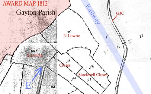
The history of the two Lowne fields are as follows. In the 1729 survey map they are absent and presumably not cultivated. By 1757 they are both let to Wm. Plowman. In the 1812 inclosure award map, below, they are both shown at the limit of the inclosure by that time. Either common land or waste land extended towards where the railway and the canal were to be routed. By 1838, Nether Lowne had become overgrown, presumably, as the Grafton records show it is "in hand" - by then called "Lownd". A sizeable patch of heavily overgrown land was therefore sold to Thomas Shaw. |
 |
There is a good reason why the fields were
not easily manageable - especially the lower field. They are based
on clay with a tendency to loose top soil due to their slope.
Being sheltered they are liable to collect windblown weed seeds and any
that are suited to the clay will flourish. The name "lound" or "lowne" means a grove in old
English, a dell in modern terms which would readily become overgrown.
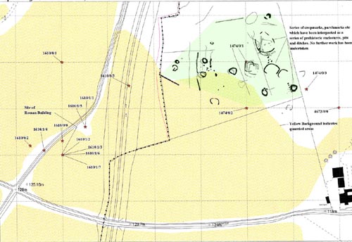
The "E" in this map, also superimposed onto the aerial picture, is placed at the end of an access track (no longer present to its full origin extent) joining the Gayton-Blisworth road . With common land to the north and east, this track would be the only sensible one for a Blisworth farmer to use. So why would there be so much interest in just a couple of fields. The answer to that is shown on the next map from the "Monuments Records Office" which indicates a cluster of animal enclosures etc. probably of pre-historic origin. The position on the hill coincides with where ironstone would be near the surface. |
 |
The extent of the marks, which were noted as
crop marks in the 1950s, is shaded in green and the same area is also
shaded in green on the aerial picture.
The dotted line is the Gayton parish boundary. It is significant, I think, that the area of the cropmarks runs into that of the two Lowne fields. The idea that this was a place of pre-historic settlement, especially in the discrete lower field is very plausible. It could have had significance in the Saxon era also. The size of the domain of Blisworth (ie. Blidesworde) by 1068, as indicated in the Domesday survey, seems quite small compared to the current parish and it is likely the area was regarded as waste - it might not have been seen! Gayton is not even recorded in the survey. |
 |
On the "monuments" map above is
shown in pale yellow the extent of ironstone extraction, 1860 to
1905. This is clearly wrong as no indications of prehistoric
activity would be seen from the air on
disturbed land. It is also noteworthy
that the clusters of finds (of objects of antiquity) indicated on the
map to the west relate to the Roman Villa that was originally discovered in
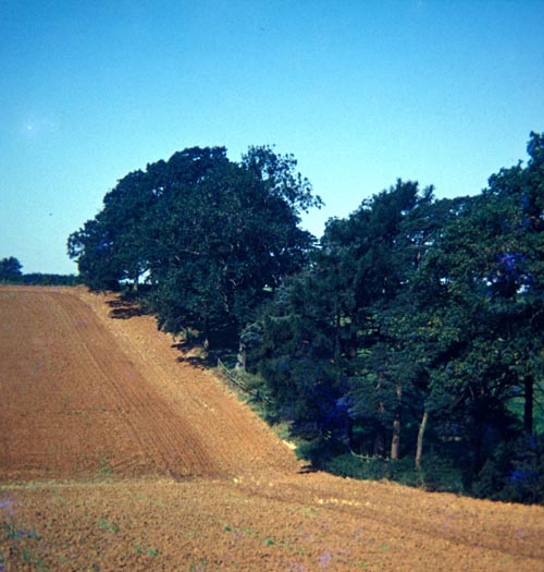
1840. That area was of course obliterated by the ironstone works. It is noteworthy that in Mona Clinch's time the features were recognised as pits in which animal bones were to be found. Hence the features are evidence of a settlement nearby. The underlying aerial photos are shown here, courtesy of NCC. The remaining three pictures have been taken recently. This one by GF in 1989 shows the pronounced groove in the field in Upper Lowne. "Upper Lowne" is private property.
|
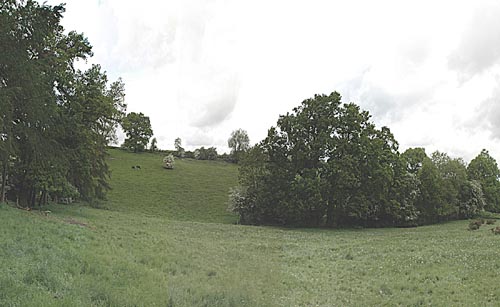 |
The "Nether Lowne" is private property. The groove continues into Nether Lowne and is shown here, as the area beyond is in partial shadow, descending from the left and into a wooded pond. |
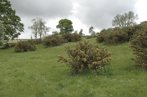 |
Near the lowest point by the boundary with the housing park, looking south up the mini-valley, the field still shows a distinct unwillingness to be cleanly cultivated! These are gorse bushes which normally populate sparse unkempt habitats - an indication of the field's earlier wildness. |