|
Throughout the text below there
are links to a parish map, ie. (MAP), which help locate the various
features The objective of this article is to concentrate on pre-war details. |
| General Works
The thorough-going book "The Natural History of Northamptonshire",
1712 by John Morton, BA Oxon and advisor to Queen Anne, includes the
conclusion there is no mineral interests, esp. iron, in the County of
Northamptonshire. He does however cite a number of types of
limestone and many limestone quarries at places such as Collyweston,
Roade, Gretton, Helmdon and Welden. Also a sand-coloured stone
quarry near Eydon. His review sometimes extends beyond the County
border as he mentions the heaps of slag left by presumed Saxon
ironworkers near Gretton and Corbei (Corby!) and the 17th century
attempts to work some more iron out of it. The ore was evidently
not as rich as that in the Forest of Dean where slag was been re-worked
to good profit. Morton described ferruginous limestones in
Northamptonshire, near Northampton and Desborough, that have a
pronounced rust colour and may contain a dark iron marcasite. He
described the stone with fissures and frequent cavities full of ochrous
sand and it is obvious, to the present reader, he was describing
'ironstone'. He said that the locals referred to it as ironstone
on account of its hardness and its weight (elsewhere referring to a
specific gravity of up to 3.1) but he cautions "this is erroneous
for there is very little iron in it." He described the result
of an experiment to extract iron - obtaining only one grain from a pound
of ore (0.02% by weight). All this seems to suggest that iron
extraction technology had been widely forgotten since the Saxons and is
a reminder to not use available technology as though it were capable of
telling the whole story.
Earliest Records. The earliest reference to quarrying potential in the parish is dated 1718 - "in this field is a Rock of good Red Stone; & Another of White Stone" (see below). Geo. Freeston found a reference, now lost, to a claim that Blisworth Church was built of local stone, which would indicate 13 and 14th Century quarrying but this cannot be pinned to any particular location. The Church tower uses some heavy iron-bearing limestone which has weathered very non-uniformly. Some has weathered hardly at all and such robust material would be worthy of smelting, being a high-grade iron ore. The Romans established iron extraction at Duston and Hunsbury so it would probably have been known at the time of building and then forgotten, and re-forgotten, that some local stone contained iron. The iron would be irrelevant to the early builder because the stone was much harder than the limestone and could be used in places where strength was paramount. The parish is crossed from west to east by a pathway known as the Saltway that was used in Roman times. Another path, the Oxenford Way running approximately north to south, borders the parish on the Tiffield side and is said to relate to Saxon trading across Mercia. These paths pass close to quarrying sites known in recent times. Because a stone might have been revealed at these sites as an outcrop in the terrain, some may have begun as a quarry many centuries ago. The
search for a clue: the fact that many of the oldest cottages in Blisworth are built mostly of
ironstone suggests a significant local availability in the 16 or 17th
Centuries, this without having to dig
under a thick overburden of limestone. Such stone may have been taken from places
where the
ironstone virtually outcrops. Worthy of brief mention are the ancient works once defined by crop marks to the northwest of the village in fields originally known as The Loundes. The region is coloured light pink and marked 100BC in the (MAP) because the Northampton County Monuments Records suggests this age. Also is offered the opinion they might be clay or stone workings, thus some form of early mining, or be simply enclosures. The overlapping circle impression is curious anyway. It does not seem too far fetched to suppose that, while the site suggests a 100BC age, it was visited by house-builders for "red stone" who got what they were after without 'modernising' the look of the site. The site is similarly positioned near a rock-clay transition, as in the case of the Fox Covert site discussed above. The diameters of the features seem far to big to be the remains of iron extraction 'furnaces'. Evidently, a little ground investigation has been done; Mona Clinch in her 1938 book on the village gives the following account. Curious Pits noted at Blisworth during ironstone workings (July 1886). In the ironstone workings ' little pits ' are commonly met with. They are a few feet in diameter, and seem to have been built from the exterior, as the lining stonework is better and smoother on the outside than the inside; also, there is a space outside filled in with rubble. The peculiar thing, however, is that they are all more or less choked with a quantity of bones of animals—horse, ox, pig, dog, red deer, etc., perhaps, and some pottery. The pits were not large enough for the animals to have been put in whole. Mr. T. J. George collected some bones (as I did also) and some pottery. Also Roman coins were found in the near neighbourhood, and the opinion formed was that the pits themselves might be dated as of Roman times. Since the period above named, 1886, much ironstone has been got, but I have not heard of other similar pits being found, so they must have occupied rather a limited area. Perhaps the pits were water wells originally, but this is by no means certain. Ultimately they appear to have been refuse pits only. Beeby Thompson F.C.S., F.G.S., assumes the pits to be of Roman origin, it is interesting to note that several fragments of Roman pottery were found in nearby Stockwell field during well sinking operations in 1928. |
| 1718 From the notes by Wm. Taylor of Heyford for Bridges' History of Northamptonshire (M300, N.R.O.) it is evident that the curate of Blisworth knew of quarries - "in this field is a Rock of good Red Stone; & Another of White Stone in a place called Salt-Way". We recognise the red stone as that used in the church tower and widely used in village cottages (often in banded arrangements with the weaker limestone that are common in Blisworth) but the curate does not state the location of the quarry. For the white stone (clearly meaning limestone) he says 'by the Saltway' and by reference to the (MAP) we can pick out Slatpitt Furlong near the label (2) and, near the label (1), the SSSI quarry and a location labelled '1805', both for limestone. The Saltway ran across the intervening fields to join (1) with (2). We are lucky to have an aerial view of the western end of Slatpitt, being named for reasons that the limestone could be easily induced to split into slates. The aerial view shows the barrow tracks left by the presumed medieval workers. The house at bottom left in the picture was Glebe Farm, see map. The quarry that is given the SSSI status has some unusual Jurassic fossil deposits in the limestone. In the 20th century the quarry is known as Rectory Farm quarry but the land only became rectorial in c.1800 and so the quarry must have had some other name, now lost, before that. |
| 1805 This is the date of the inclosure award map although a few fields were not inclosed until c.1840 and a large number such as Slatpitt were inclosed a hundred years earlier. The award document refers to three field areas each of about one acre that were "reserved for the continued extraction of stone" implying they had already been established as quarries for a period of time. Two pieces are near a parish boundary and sited to the furthest east part of the parish - marked by a light blue circle in the (MAP) - and the third is near to label (1) where there is another blue circle, ie. the same Rectory Farm quarry. Carting stone from either of these to the nearby road, Courteenhall Road and Towcester Road respectively, would have presented no problems. It is not clear what purposes were allowed for the stone and whether anybody was expected to pay for it. It was obviously either Grafton's stone or the Rector's after c.1800 and so was used to maintain roads, houses and church buildings in the village. The Victorian reputation of the Duke was to look after his rented-out cottages only to the extent of thatching and replacing window glass. Pointing and wall repairs and anything internal were the responsibility of the tenant, it was said. Maybe tenants were given free access to the stone as many would have been unable to afford paying. |
| 1820/1 Well
documented by Geo. Freeston is the instruction in 1820 by the Duke to
his agent John Roper to take an expert and go round the parish and find
a potential quarry site that might be developed for selling good
quality stone. John Roper then established the quarry towards the
east of the parish, labelled "The Stone Works 1821 to 1920" in
the (MAP). This 'new' quarry was
contiguous with the quarry already opened probably well before 1800 and
it seems likely that most of the 'research' would have been done at the
bar in the Duke of Grafton's Arms. As strongly suggested by
the article on the stoneworks,
it is likely that the Duke was unaware that John Roper was already
running that quarry and taking a large share of the income from
it. The date 1820 thus points to the start of an open
commercial availability of stone from Blisworth rather than to the start
of that particular quarrying area. Maybe the tenants
mentioned in the previous paragraph had to pay the
Duke's agent for any stone.
The Grafton Villas at the entrance to Ford Lane (now Station Road) were built by the Duke by 1840 as an advert for the stone - "be an ornamental adjunct to the archway as well as show off our stone to the best advantage", the agent's underlining. There is an article that deals with the horse railway used to shift the stone to the bank of the canal labelled (3) in the map. From that wharf the stone, as building stone, was delivered to various inland ports. Late in the life of the quarry, the stone was mainly carried to the Hunsbury iron works, using the Northampton Arm canal, as a flux in the smelting of iron ore. The Stone Works quarry contained a seam of good limestone up to 20 feet thick. In recent years a survey had confirmed this thickness and there was some careful consideration given to re-opening the quarry at a new point nearer to the Stoke Road but the plan was not taken up. The entire quarry was filled with waste in the 1970s and the line of the horse railway running from it was obliterated. The line can be picked out however as it approaches the location of the wharf. |
| 1838 This
was the time of a major Grafton Survey commissioned by a new keen Duke. An oblique reference to
any mining
potential emerged in the survey when engineers were looking for a reliable
source of water for the steam engines running on the railway through the
County that had opened that year. At the points marked 'w' on
Cliff Hill, south of the railway line - see (MAP),
a deep dig was carried out to
establish the level of the water table. In the digging they
discovered a rock they must have thought rather hard - perhaps useful!
1851 Some message must have got through to the Duke since, at the 1851 Exhibition in the London Crystal Palace, Northamptonshire landowners advertised their potential value in terms of iron deposits. John Morton's view of things was being revised (see opening paragraph). This of course sent a flurry of surveyors back to the County to find the all important coal to go with the iron ore. They were not lucky. By the mid-1850s there were tests being carried out on the ore from various places to see how smelting conditions needed to be adjusted in view of the main contaminants in the ore. Regular extraction by 1852 was established at the site next to the turnpike labelled (5) in the (MAP) by partners Clare and Hickman and from 1860 there was better organised opencast mining extending across the fields to the east and north of the village linked by a horse railway to the dispatch point labelled (6) in the map. The same partners began the mining in these eastern fields earlier than 1860 but there is no record of the exact location. They lobbied unsuccessfully for a connection with the railway and then gave way in 1854 to Mr. W. Arundell who established some sort of dispatch point at (6). In 1859 Arundell failed and the mining agreement was then won by G.E.Bevan and Company, already established at Duston, who mechanised the project more successfully and developed the dispatch point at (6) into a more workable scheme. Also in Gayton parish mining made an early start in 1850s with George Pell (who later gained fame in owning blast furnaces) and it is evident he began in "Britain", a location mentioned above, with a tramway and an overhead loading gantry communicating with a field to the south-east. With the building of the SMJ railway line, that field (shown here) was cut off and so the gantry had to be rebuilt to also cross the railway cutting. Pell's tramway that originally descended to sidings by the Birmingham-London main line had to be rerouted to make room for the SMJ line. Pell's site and gantry was later taken over by Wheldon and the tramway running to the south-east was taken under the road to the south to service even more extensive surface mining c. 1895 to 1910. The windmill was not in use after 1882 and the ground there would have been lowered by at least ten feet as it was over a considerable area known as Blisworth Pit No. 1. The pink arrow extending towards the village, shown in the map, represents an opportunist claim for more ironstone in 1912 -13 just before the new school was built at the road junction. There was another relatively late incursion labelled 1910 near to the brake-drum. This appeared set to mine out the remainder of the allotment field but, fortunately for today's allotmenters, it was halted by failed economics. A group of wagons were left in a deep cut that still exists amongst the allotments. The wagons are shown in the first picture on ironstone, Part I. There is an interesting data set in Mona Clinch's 1938 book giving thicknesses and descriptions of limestone strata presumably from workers' memory at the close of limestone quarrying operations - the emphasis is upon limestone. The dispatch point (6) for this complex of fields, 'ironstone Part I', in fact consisted of a bridge over the canal with a large hole in it. Wagons were lowered onto the bridge and tipped up by winch so that the contents emptied into wooden coffers in narrow boats moored below the bridge. Bevan invented a brake-drum arrangement, marked 'd' in the (MAP), to enable an empty wagon to be raised up the 1 in 5 grade from the bridge using the weight of a descending full wagon. This required some ingenuity and a suggestion for how it was done is indicated in the box below with the diagram showing how the wagons were marshalled. Note that the railway passes under the Stoke Road through a short 'subway', as it was called in those days. The ore was either taken to railway sidings by the station to be conveyed to South Wales or Nottinghamshire or taken down the Northampton Arm canal to Hunsbury iron works which housed a couple of blast furnaces run by the Phipps family. |
|
|
| In fact, in 1901 the entire east side mining was taken over by Phipps (as were all the
public houses some years before that!). With the start of WWI, some reports say in 1912, the furnaces at Hunsbury were closed down through lack of men and were
not restarted after the war for lack of men, money and horses. No
further mining was done in the eastern fields. There are two
remaining stretches of mining gully; one in the allotment field and the
other adjacent to the north side of the Courteenhall Road where the
extraction of nearly 20 feet of ore is evidenced by the depth of a
terminating gully. Noteworthy points are that the mining by Phipps
after 1901 was carried out carefully with pathways from the Back Lane
always kept open, once with a temporary bridge. However, the miners paid
rent for only the strip in which they worked at any one time and they
left a devastated area of subsoil for gardeners or the farmer to deal
with. Rent appeared to be paid to the Parish Council and it therefore
boosted the precept.
Across the Courteenhall Road is the street Wellspring which is also set 15 to 20 feet lower than the road. In fact the horse railway ran under the Courteenhall Road through another subway. Just at the place where this subway was located is now the entrance to a new housing estate called Ladyfield. We have an archive picture of the mine taken from the road at that point. Incidently, mining was generally carried out to a well-defined plan that lead to the railway being repositioned progressively across a field, this is explained with the picture that follows the above-mentioned archive. The final layout of the railway c.1910 is shown in an OS map. Builders have skillfully built up the ground level and ensured that the houses stand on adequate foundations. The work leaves little for the imagination to grasp regarding the layout of this area. The mining of ironstone in the County has been comprehensively dealt with in Eric Tonks' book "The Ironstone Railways of the Midlands" and Blisworth and its surrounding area is covered in part III. The topic is also discussed by David Blagrove in his book that is mainly about the canal in the area and the Blisworth Tunnel, "Two Centuries of Service", pp65-67. There are frequent references on the website to people who worked the ironstone or limestone mines. The mines and quarries and the railways were the mainstay of employment in and around the village. Indeed workmen from neighbouring villages would walk to Blisworth either every day or weekly and seek board in the already over-crowded cottages. In 1911 there was a political row when the Duke of Grafton was accused of providing insufficient houses for villagers. It was the local immigration of men looking for work that caused the 'famine'. Sadly the issue went away once both quarries had closed just before the WWI. |
| 1870 - 1914
There were two other ironstone 'fields' in the parish run by Bevan. They were both to the west side of the parish, both
dispatched at the canal at two specialised wharfs that are both labelled
(7) in the (MAP). The southerly
dispatch point was again a horse railway and it probably used ropes to
help control the final descent towards the chute
over the canal that is pictured here. The two successive pictures and the
map, in the previous link, help fill in details about the chute of which
no residue can be found at all today.
An intriguing 1950 OS map which carries markings in ink, probably by Eric Tonks, has been found in the Freeston Collection. It is shown here and indicates that the above rail system used a winding drum. Note that evidently towards the end of the mining there was thought to be an additional rail spur extending eastwards from what is now the allotment field. Also, two bridges under the Courteenhall Road are implied. An amusing snippet, typical of George Freeston, is made available here. George was old enough (~5 years) to tease the foreman, Mr "Toby" Durrant, at the closure of the mines. Upon closure, there was acres of playground for the children with no foreman to bother them at all! Another field was mined with a dispatch point to the railways, labelled (8), and was run by another entrepreneur, R.B.Sparrow according to Tonks, who was simultaneously serving the expanding iron industry. Dispatch point (8), which is in Gayton parish, consisted of a wooden 'bridge' passing over a standard gauge railway linked to the SMJ line. From the bridge, wagons were emptied into rail wagons. |
| 1943 - 1967
See Ironstone, Part II & III
During the war the call for an expanded iron industry was desperate.
Fields were opened up by Richards, Thomas and Baldwin and provided with rail links to the
L&NW main
railway, labelled (9) in the (MAP). A
1947 aerial photo (NRO) shows the first extended gulley in the area
marked as 1943 in the map. A little later, some large electrically driven machines were adopted as it
became evident that the ironstone on the west side of the village was
covered by 10 to 15 feet of limestone. By the 1960s the limestone
was being removed with one machine, the larger, and the ironstone with
another. Villagers recall the all day characteristic grinding
sound as the machines closely approached the edge of the village.
On these high lands of Northamptonshire, the 'natural' full complement of strata, working downwards, is loam, glacial clay, limestone, ironstone and then a considerable depth of lias ie. blue clay. The earlier mining fields on the east of the village had little or no limestone overburden. A glacial action must have scraped the limestone off. There is neither limestone nor ironstone in the valleys to the north of these high lands because glacial run off has presumably cleared it all away leaving, in some locations, a sharp contour as the rock nearly outcrops over the clay. Eric Tonks' books on "The Ironstone Railways of the Midlands" covers the history very well and nothing more will be said here. This site has a collection of pictures mostly taken by locals to the village, starting with Ironstone, PartI. |
| Tony Marsh 25 February 2008 |
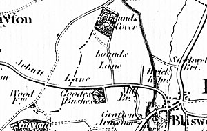 A roam around the parish reveals no substantial hollows indicative of an
ironstone quarry. There is one contender; "Fox Covert"
in the field below Hill Farm on the Gayton Road. This wooded
area is given in Bryant's 1827 map, see inset, as "Goodes
Bushes" which implies that if it once included a quarry then it was
worked out in the 18th century or before that. In fact the Goode
family rented an adjoining area from the Duke of Grafton and Goodes
Bushes, including Fox Covert, was kept 'in-hand', being deemed
unworkable. In more recent maps Fox Covert is shown embedded in a field and not contiguous with the road
and, in the (
A roam around the parish reveals no substantial hollows indicative of an
ironstone quarry. There is one contender; "Fox Covert"
in the field below Hill Farm on the Gayton Road. This wooded
area is given in Bryant's 1827 map, see inset, as "Goodes
Bushes" which implies that if it once included a quarry then it was
worked out in the 18th century or before that. In fact the Goode
family rented an adjoining area from the Duke of Grafton and Goodes
Bushes, including Fox Covert, was kept 'in-hand', being deemed
unworkable. In more recent maps Fox Covert is shown embedded in a field and not contiguous with the road
and, in the (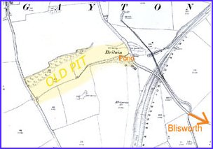
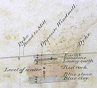 The inset shows the diagram that appears on the survey map that related
to a spot a few yards
from the village windmill, which would have been turning at the time. In the
early 1700’s John Morton had reported to the government of the day
there was no iron ore in Northamptonshire yet here surveyors have
labelled a rock as 'ironstone'. The 'Red Rock' that is ten feet
thick is also ironstone, but they do not say so and at the other place
marked 'w', nearer
to the Courteenhall Road, the ironstone seam was evidently 16 feet thick.
The inset shows the diagram that appears on the survey map that related
to a spot a few yards
from the village windmill, which would have been turning at the time. In the
early 1700’s John Morton had reported to the government of the day
there was no iron ore in Northamptonshire yet here surveyors have
labelled a rock as 'ironstone'. The 'Red Rock' that is ten feet
thick is also ironstone, but they do not say so and at the other place
marked 'w', nearer
to the Courteenhall Road, the ironstone seam was evidently 16 feet thick.

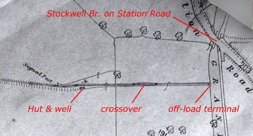 We have no trace of
the northerly canal dispatch point; even the field boundary that is evident
today that might have suggested the run of the railway was established afresh as recently as
1967and is not aligned with the path of the railway.
However, an 1890 OS map, shown here, provides a glimpse of the rail and
wagon control arrangement which fed an off-load terminal probably very
similar to the one mentioned in the previous paragraph. Halfway
down the slope there is a rail crossover section. The logical
reason for it to be placed just halfway is that a cable system was used
to lift the empty wagon up the slope with the weight of a full wagon -
just as at dispatch point (6). The person in charge of the
changeovers appeared to have been accommodated in a hut with the luxury
of a well. The precise way in which the signal post was used is
obscure as is the manner in which the exchange of wagons was controlled.
We have no trace of
the northerly canal dispatch point; even the field boundary that is evident
today that might have suggested the run of the railway was established afresh as recently as
1967and is not aligned with the path of the railway.
However, an 1890 OS map, shown here, provides a glimpse of the rail and
wagon control arrangement which fed an off-load terminal probably very
similar to the one mentioned in the previous paragraph. Halfway
down the slope there is a rail crossover section. The logical
reason for it to be placed just halfway is that a cable system was used
to lift the empty wagon up the slope with the weight of a full wagon -
just as at dispatch point (6). The person in charge of the
changeovers appeared to have been accommodated in a hut with the luxury
of a well. The precise way in which the signal post was used is
obscure as is the manner in which the exchange of wagons was controlled.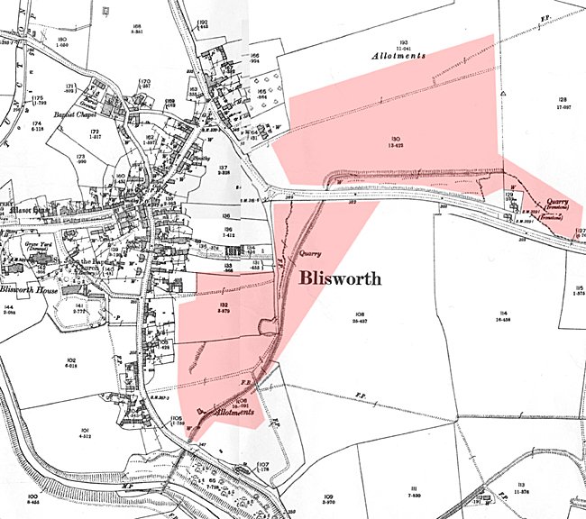