The Limestone Quarry and Railway
An advert which appeared in the Northampton Mercury newspaper, August 17th,
1839:
Lime and building stones are always in readiness to be forwarded by canal
or otherwise at 1/8d per ton, lime at 2/3d per qtr. ton. Chimney pieces, paving,
steps, landings, window heads, sills, coping, sink
stones, pier caps & staddle stones
all executed to order.
NB. the capabilities of these stones
for ashlar, tooled,
rusticated and other descriptions
of plain and worked ornamental
masonry may
be seen at the buildings erected at the
quarry and near the railway station at Blisworth.
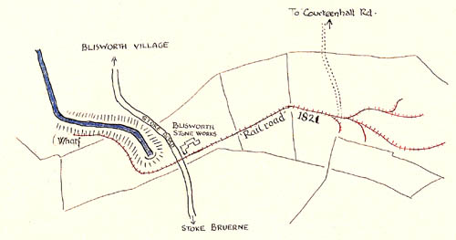
The quarry identified in the advert lay behind the
building "Blisworth Stoneworks" on the Stoke Road near to the mouth of
the Grand Union canal tunnel. The stone works building was probably used
to accommodate the manager and his family and the stone works office, built
around 1840 - photographs in the Stoke Road pages,
part II. It has been said that in 1821 the duke of Grafton instructed his
agent John Roper to take experts around the estates to find a suitable site for
a (new) commercial quarry and this one in Blisworth was the result. As
clearly indicated by some later Grafton documents dealing with details about the
quarrying business, the quarry had been running probably as early as
1800.
It is shown on the Inclosure Award map which is dated 1808 or 1815.
Knowing the doubt placed on Mr. Roper's dealings, the quarry may well have been
commercial before 1821 but run by Roper himself. When the over-hill horse
railway closed in 1805, the tunnel having been opened, the rail components ie.
rail plates were next used on the Northampton Arm to Northampton railway
(1805 - 1815) before
being offered gratis to the quarry business to assist in the delivery of the
stone from the quarry to the bank of the canal - the canal company made the gift
to promote trade on the canal. At some time later, the rail plates to the
quarry were
upgraded to a familiar rolled forged steel cross-section. The plan of the
railway in roughly 1900 is shown in the map below. This is George
Freeston's map, made in 1953. He is justified in dating the railway 1821
because there were found many documents at the NRO indicating accounts paid by
Mr. Roper for work on "makening a new railway". In 1966 the
owner of the land decided to clear the area occupied by the railway and then
discovered a number of pieces of plate similar to that used for the hill railway
and by 1970 George Freeston had written up a pamphlet on his findings on this
railway, "Northamptonshire's Third Railway". A copy
can by downloaded from here.
There was some subsequent interest in the quarry when pupils of Campion
School paid a visit in 1976.
 By 1839 the Duke had arranged to build the twin houses known as Grafton Villas
at the junction of Station Road (Ford Lane) and the Northampton
Road. The Railway section and the Railway
Arch section has more detail about the Villas and provides a link to
the particulars given as listed buildings.
By 1839 the Duke had arranged to build the twin houses known as Grafton Villas
at the junction of Station Road (Ford Lane) and the Northampton
Road. The Railway section and the Railway
Arch section has more detail about the Villas and provides a link to
the particulars given as listed buildings.
The quarry closed in 1912 due to the downturn in the
economy. By then the chief use of the limestone was as a flux for the
steel making at the Hunbury Furnaces run by the Executors of Pickering Phipps.
An additional problem was one of transport - by WWI there were no horses
available and horses were needed to operate the railway to the canal and draw
the narrow-boats charged with stone to the furnaces. It is fortunate that
George managed to interview a Mr. Trusler in 1976, when he was aged 83 years.
Mr. Trusler recalls when of age 14 he commenced work at the quarry (1907) for the sum of
5 shillings (25p) per week. His job
was to control the traffic by " flag" signals at the Stoke Road crossing. He remembers too a switch point some 50 yards east of the crossing, which
if operated in an emergency simply derailed the trucks. There were others
in the village that remembered "flag" men, one of whom, and possibly the last,
was
named " peg-leg" Clarke, for he had previously lost a leg by accident when working in the quarry.
Remembered too were the loaded trucks, usually
four in number, which were allowed to run down by gravity to the canal with an attendant "spragger"
or brakes-man. Empty trucks were returned by horse. As part of the
rail descends at a gradient of over 1 in 25 (the average grade is 1 in 25), the brakesman would have to ride on
the group and judiciously apply braking effort through levers. We have no sight
of the mechanism but it was probably of the constrained-scotch-type and would
have been applied to wheels on all the wagons in view of the grade and the
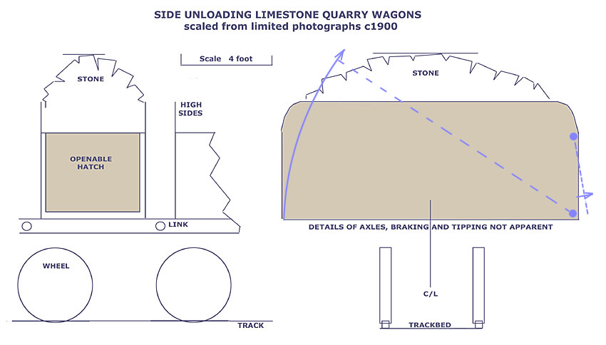
consigned total weight exceeding 50 tonnes. An attempt is being made to deduce approximate
details of these wagons.
From the Blisworth Parish Council minutes for Feb 11, 1907 comes
the following: their only reference to the limestone railway.
Stoke Road Tramway Crossing - The Clerk was also directed to call
the District Surveyor's attention to the worn state of the road over Limestone
Crossing.
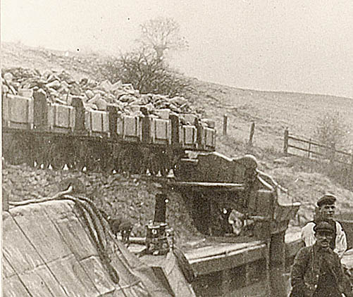
Nothing remains of the wharf area for limestone but a
pair of photographs, 08-03 & 08-04, shows the wagons used and
shows that they were side-opened to discharge stone down a short ramp into the
boats. An enlargement of the 'chute device' is shown below. In one of these two photographs is shown also the ironstone
bridge which delivered wagons from iron-ore open mines. The iron ore
wagons at this wharf discharged stone through an end-flap and through a hole in
the centre of the bridge while being upended by an attached rope. See below for a
present day impression. An overview of Blisworth mining is
given here.
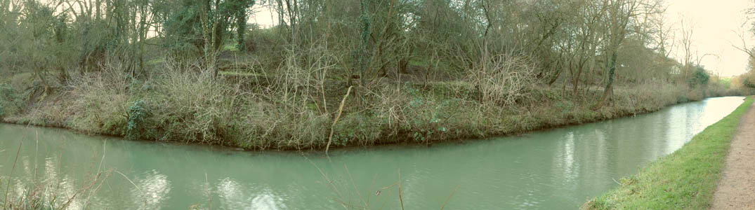
January 2008 - a panoramic picture of
the wharf area. The wooden stumps of the ironstone bridge cannot be
identified for sure nowadays but the line of the railway to the wharf is
highlighted by a clear grassy slope.
The line is emphasised in this smaller picture below,
which also shows a montage of the loading chute.
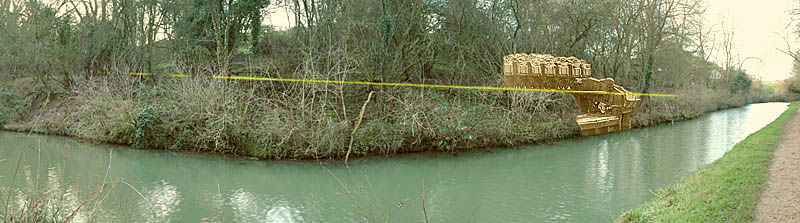
photographs by Tony Marsh
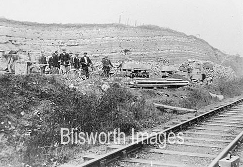
This 1920s picture below has some resemblance
to the quarry behind the Stoneworks farm. The wagons look very similar
as does the strata but the railway is in far too good a condition to have
belonged to Blisworth (see 'Sam' Cherry).
Recent Years: The quarry
became just another exciting extension to the play areas for Blisworth children
after 1920. It was used as a bunker for exploding the odd un-exploded bomb
in 1942. By the 1960s it had become a "tip" for refuse operated
by a firm called Sandspinners operating via the offices of Sir Hereward
Wake. In 1987 there was an application to add an extension to the tip
incorporating a large adjacent field to the south with an access off Knock
Lane. Fortunately the threat to ground water was considered a serious
risk. The implications for heavy traffic for 10 years was also a concern.
The application was turned down. By 1995 the whole quarry area was domed
by a considerable quantity of soil and was returned to farming.