|
HORSE RAIL WHARF AT BLISWORTH ARM Click here for a review of the History of Blisworth Arm |
|
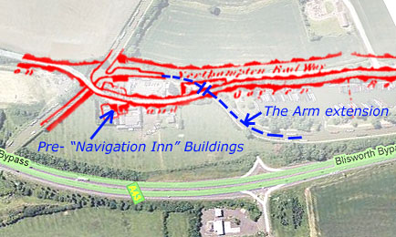
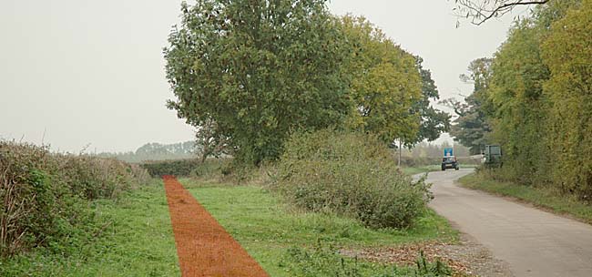
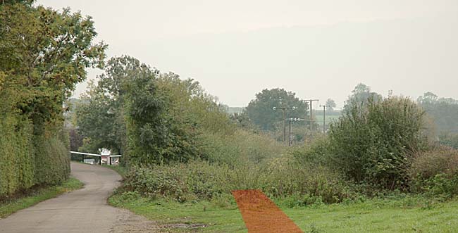
With reference to the map shown on the Neighbouring Villages I page and the overlay map below this paragraph, the two pictures reproduced at the bottom of this page have been recently taken looking first east and then west from a location about by the end of the word "Northampton" just to the north of the area now occupied by Gayton Marina. The map in "Neighbouring Villages" shows a well-extended watery spur presumed running parallel to the railway for a distance, thus in contrast to the Award map.
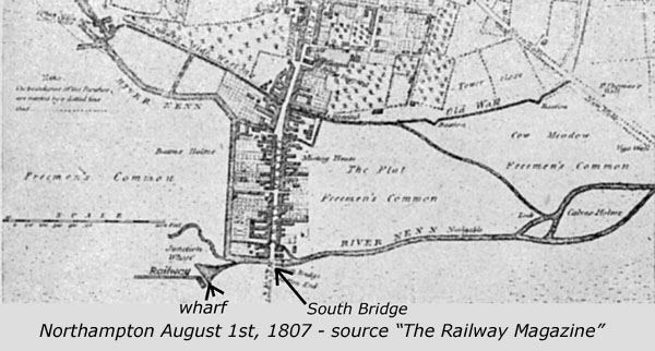
With the establishment of a canal link from the Grand Junction Canal and Northampton, history records that a horse rail was first built c. 1805 before a proper single-width link incorporating a flight of locks was finished. By about 1815 there would be no further need for the horse rail and so it is not included in the map - just the unused spur remained. The pictures below seem to indicate remnants of the spur and the track of the railway. There are added some lines in dull red to indicate the path of the horse railway as shown in a recently found map at the NRO that is probably dated c. 1810. David Blagrove in a private communication has pointed out that the map was associated with a conveyance, dated October 20th 1807, for the land taken by the canal. From an article entitled "Grand Junction Canal Railways" (no author disclosed) in The Railway Magazine, 531,Sept 1941,390-392 there are the following observations. In relation to the rail-road over Blisworth Hill from which metals were used for this rail-road, Thomas Telford in May 1805 reports that "the space occupied by the late rail-road over the hill, by being repaired, will answer the purpose of a road for the canal horses and the whole breadth should be retained by the company (GJCCC.)" [the toll road now known as Stoke Road was built for this purpose - perhaps unknown to Telford] Priestley's book of 1831, Historical Account of the Navigable Rivers .., says that the communication which was established in 1805 was a double railway allowing carriages, going different ways, to pass without interruption. A later publication "The Penny Cyclopaedia" stated in 1840 that a double railway exists despite the fact that the canal arm was completed in May 1st 1815. As the Blisworth Hill line was some 2 miles shorter than the link to Northampton, it is possible that the balance of rails came from the Aylesbury stock. Telford's report includes details of the rail link - the downgrades on the line were 1 in 1800 near the main canal, 1 in 48 in a middle ¾mile section and 1 in 800 near to Duston Mill and the town. The termination at the town consists of a very commodious wharf shown in the plan below, the location being approximately 160 yards west of the South Bridge. The line of the railroad followed the Milton Rd for ¼mile [as can be seen in the NRO map hyperlinked above] and then followed a course now drawn out point-for-point by the Arm, with the railroad once close by the towpath side [this last detail seems wrong!]. The Burgesses of Northampton in 1809 were not inclined to consider the railroad as permanent and reported, " ..we observe with regret the railway substituted for a canal, a mode of communication equally as injurious to this town and neighbourhood ... the articles conveyed are subject to great waste, breakage and pilfering .." Such was the reputation of the GJCCC. in Northampton. |
|
|
|
|
|
|
|
Historical copy of the Railway Magazine supplied by Andy Newbery |