|
This is a page on the independent website, home page: http://blisworth.org.uk/images/index.html The History of Blisworth Arm
The aim of this page is to reference documents providing historical detail and to offer (a) a simple timeline, (b) a map and (c) a list of the chief users of the Northampton Arm (up to 1970). This page
references seven others dealing with the Arm: There is also an interactive map of Blisworth Arm hamlet to indicate location of some of the historic buildings. Acknowledgements: With thanks to all the people who have helped in assembling this information: David Blagrove, Reg Spittles, Phil Lizius, Brian Collings, Sally Edwards, John Dale, Doreen Blood, James Payler, Dave Goodwin and to George Freeston who rescued much of Millner's correspondence now at the N.R.O. --------------------------------------------------------------------------------------------------------------------------- Domesday times, ie 1066 - this would all be 'waste' land; nothing the Normans cared to make a note of except for a track, part of the very old Oxenford Way trading route, probably dating from the 8th century if Offa of Mercia established it, ran through the area on a roughly north-south axis joining Oxford and Northampton via Greens Norton and Tiffield parish. [One theory supposes that the ancient way coincides with the axis of the road through Blisworth Arm, another supposes it follows the road from Gayton, in the immediate vicinity, and joins a little to the east of the Arm End. Medieval - Imagine just this track, dividing the parishes of Blisworth and Gayton, and fields for half-mile all round. Gayton parish was inclosed very early whilst this part of Blisworth parish was not inclosed until c1800. There would just be the locals toiling all day at their furrows, listening out for the village bell to toll their "tea-time". 1757 - The entire area to the south of the track was part of common land called nether field or Blisworth Field. The nearest enclosed field (The Lowne) was let to Wm. Plowman, a descendant of a beneficiary of the 1650 Cromwell crown land purchases. By the time of the Grafton Survey in 1757 most farmers who were judged to be good farmers were awarded some grant of inclosure over parts of the common land so the "ridge and furrow" pattern of family farming was being pushed out. The track might be less maintained than in medieval times, running along the Blisworth and Gayton parish boundary, probably chiefly serving the already inclosed fields (c1600) in Gayton parish. The 'trading route' had been transferred long ago to an old road passing through Blisworth that was soon to be upgraded to a turnpike (thence the A43). 1794 - The main cut of the Grand Junction Canal was established as far south as the turnpike in Blisworth village, where a transhipping wharf was created. The locals would not see the point of this man-made 'river' . . . yet. The track is bent a bit and forms the beginnings of a short street through a hamlet. 1805 -
Joining the Grand Junction Canal there was dug a ~150 yard long waterway that
led to a horse railway connecting the canal to Northampton.
The place was called Northampton Arm and remained such until
about 1891 when the name Blisworth Arm was used in the census. Pickfords moved from Blisworth wharfs to the Arm to operate the horse
railway, having operated the Blisworth Hill railway from 1800 - 1805
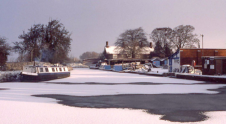
while the tunnel was being finished. 1807 - a public house was opened and believed to be called initially The New Inn (for not more than 20 years), later named the Navigation Inn - photographs. On the 13 January 1806, George Moore invoiced the Duke of Grafton £1 16. 0. for the wooden scaffolding (skafles) for a public house at Railway End, Blisworth Field. In the 1809 Award map it is shown as an unlabelled (farm) house in the corner of a large field. See details in the associated page. 1815 - May 1st, the entire Northampton Arm, as a single width waterway, had been dug and was opened to traffic - thus the River Nene was connected to the canal system. The horse railway was closed and Pickfords Company moved away from the Arm. A name such as Railway End gave way to Arm End. Pickfords, a company with its roots in the 17th century, also operated fly-boats c1800 but by 1850 had closed its canal based business in favour of the railways. Although it was built as a single width waterway to save water, a proviso was given by GJCCC to Northampton businessmen that, if the locks at Foxton and Watford were later widened, then so too would the seventeen locks on the Arm. 1817 - The two cottages, which were knocked into one house as Thomas Millner's residence in 1900, were built by bridge No. 2 to serve as canal workers accommodation. c1820 - It is presumed that GJCCC established their maintenance yard at its present location more or less immediately the Arm was completed. There is a reference that the rails taken up from the horse railway were stacked at the yard and by 1824 a "large pile of rails awaits disposal". Some were offered to the Thames Tunnel Co, which commenced tunnelling operations in 1825 and it is thought that the pile of rails may have been viewed by Sir Marc Brunel, father of I.K., who was in the area in 1824 advising the Oxford Canal Co on straightening its line north of Braunston. Some rails were given to John Roper to use for the limestone railway at the Blisworth Stone Works and remnants have been unearthed by George Freeston. c1820 - A feature of uncertain dating was the bridge built across the neck of The Arm extending to the Toll Cottage - Bridge No.1. Presumably it was a relatively flimsy affair of wood, for pedestrians especially the toll-man, being a swing bridge, probably a floating one, to allow boats into the Arm. It was flanked with staging to the bank on the cottage side and joined to a substantial peninsula of land on the other side as shown in the detailed map. If the staging is what is being referred to in the taped conversation about the toll-man then the bridge was still in use after 1890. 18?? - Other features of uncertain dating are (a). establishment of the brickworks (Mr. Savage initially?) just north of bridge No.2. Although it is logical to expect brickworks from c1795, the first census record for a brickmaker at the Arm is 1851. (b). setting up, perhaps c1810, and demolishing (when?) a warehouse used by Pickfords Company - see detailed map - on the Arm wharf (c). setting up of a blacksmith nearby (see detailed map) (d) building of cottages both inside the yard enclosure (for canal staff, see detailed map and note its footnote, built sometime before 1900 and demolished by1930) and, on the other side of the road, the building of two farm cottages, before 1900, of inferior bricks next to stables, modernised c1970. Also an undated snippet is the fact that the Northampton Arm was one of the last waterways on the system to operate a horse supplied by the canal company. c1870 - Arm Farm was taken by new tenants - the Savage family; hence the name, now forgotten, for two semi-detached houses opposite the canal yard - Savages Cottages. 1895 - Thomas Millner became Canal Manager for the local section (Braunston to Fenny Stratford) and made the Arm his HQ and taking over from a Mr. Cooke. He lived in the Toll Cottage to begin with but in 1900 he took over a large double cottage as his residence - Canal House. He named his operational base there "Gayton Maintenance Yard", consistent with Grand Junction Canal convention at the time which was to refer to the nearest village by road. By this time, the conventional name for the hamlet was Blisworth Arm as judged by the census documents. Mr. Cooke later departed for USA - he was "fed up with England". 1905 - At Millner's request, a windmill pump and borehole was established near the top lock on the Northampton Arm so that piped 'mains' water could be provided for his house, the boater's services, the brickworks in both Savage's and Asplin's time and the maintenance yard. All this supply is thought to be from a high mounted reservoir near the lock - long since removed. In later years the Navigation Inn, while still part of the Grafton Estate, was included in the supply. Evidently Millner thought that the Navigation Inn was an important asset in promoting the smooth running of canal business! He makes his support in 1915 plain for all to see. 1911
- Mr. Savage's brickworks just to the north of bridge No.2 ("Arm
End Brickyard") was relinquished to a new tenant W.T. Asplin.
In the 1914 Kelly directory he is recorded a brick and tile-maker.
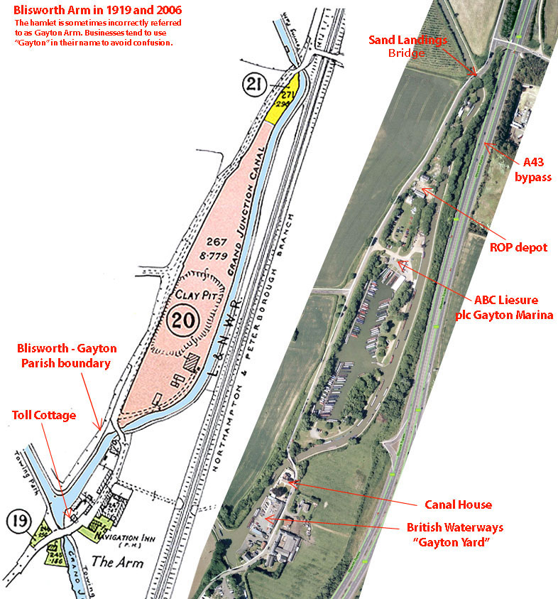
However, he ceased to use the brickworks from 1917 onwards. 1912 - Perhaps as a result of last year's bridge trouble, bridges on the Arm were strengthened with iron ties. c1919 - Arm Farm was bought by W. T. Asplin who may have been the Grafton tenant there for many years (Grafton records lost in a fire). 1919 - Lot 19 in the Duke of Grafton's Estate sale - The Navigation Inn was sold to Phipps Brewery, Northampton - resident publican A. E. Abram. See details in the associated page. 1919 - Millner recommended in a letter to his bosses in London that they acquire Lots 20 and 21 in the sale - "... I think the acquisition would be beneficial to the company": (Lot 20) "A valuable brickyard and pasture field - all buildings and the chimney shaft belonging to the tenant W. T. Asplin of Milton" - bought by GJCCC. for £500 with the let continuing - but it seems it lasted only for 2 years. GJCCC management had no idea what this plot would be used for - "let's not sell cottage plots to the public, we might want to build our own staff cottages". The area later became a source of puddling clay. 1919 - Lot 21 was sold for £75 to W. T. Asplin (preference given to the tenant) with the wharf presumably used for sand and brick distribution by canal. GJCCC wanted this plot and attempted to buy it from Asplin through the 1920s. Asplin also bought at this time Lot 22, a sand pit, on the other side of the railway (then) for £875.00 - a site now occupied by Kottler Heron and Leyland-DAF commercial vehicles, among others. There are some historic notes based on an article and copies of Deeds made available by Philip Lizius, the present owner of the plot. 1921 - Asplin ends his tenancy at the brickworks having taken down buildings and moved his operation across the railway. He used local labour in the move. 1929 - The canal through this area, formerly the Grand Junction Canal, was designated part of the Grand Union Canal. 1931
- Russian Oil Products Ltd. (R.O.P.) took a
small piece of
land, rented from GUCCC, as a depot for petrol distribution. At
the time, GUCCC
considered a whole list of possible sites but erred in favour of this one
because of the perceived fire risk. 1930s - Before WWII the canal fishing rights on the Arm were rented by Northampton Angling Society at a cost of about £10 per mile per annum. c1936 - Recorded in a postal directory is Claude Frederick Harlow at the Toll Cottage. This is of course C. Hadlow. War Years - It is thought that Hadlow possibly shared his house during the war years when the whole canal network was 'taken over' by the government. The Toll Cottage was accommodation for a government official and his family, Ernest G. Dale, who described himself as a GUCCC employee and whose job it was to manage the storage of strategic emergency foods. In 1940 Dale took over the R.O.P. depot after the petrol tanks and pumps had all been removed and started to store foodstuffs. By 1942/3 his operation must have transferred into the much favoured Blisworth (Westley) mill building which had become GUCCC property by then (see link below for John Dale's memoirs). Aerial photos of 1947 (NRO) show one small shed and an empty plot accommodating a looped drive with in- and out-gates. 1946 - GUCCC let the old disused petrol depot, newly referred to as Depot No.3, to Derngate Motors for a while and then opted to again offer it to petrol and oil companies [there must have been some canal benefit from this?] People recall Esso, Texaco and Shell being involved but the most 'solid' seems to be that the depot was used by Watsons Oils (part of Texaco) - see article link above. 1948 - GUCCC was nationalised on January 1, 1948 and came under the control of the Docks & Inland Waterways Executive of the British Transport Commission. c1951 - Arm Farm, still 152 acres, was sold to the Stroud family by Asplin's descendants. 1953 - Easter. The Navigation Inn was closed and sold. See details in the associated page. 1962 - The management of the canal system, whilst still controlled by government, was re-organised as the British Waterways Board which begat British Waterways. By now the annual charge for fishing rights had been increased by British Waterways to £200 per mile which resulted in different clubs taking over the waters. They used to come out by bus and were dropped off at bridge points. It became a little industry - some canal-side houses providing tea, hot water, sandwiches and confectionery. The push and pull train on the local line would drop off and pick up by request at suitable spots such as the Banbury Lane crossing. 1960s - British Waterways appreciated the excellent clay, for puddling, available at the site of Asplin's old brickworks (Lot 20) and proceeded to extract it. The resulting large hollow filled with water at a level somewhat below that of the neighbouring Arm and even acquired a colony of water lilies (photographed by Walter Alexander) and its own clandestine flock of fishermen who parked on the horse railway 'track' and crept through narrow gaps in the hedge. The place became known as The Lake and there were voices heard 20 years hence in Blisworth - "we want to keep our Lake". 1960 -70 - Arm Farm was bought by Harry Capell of Shutlanger and, in 1963, a new farm house was established near Canal House and named New Arm Farm. Hence a modified name for the main farm - Old Arm Farm. Not long afterwards, c 1970, the farm buildings along the road opposite the yard were modernised. 1967 - After Station Road was adopted and officially named (eight years after there was no station!) by NCC there was the question of signage to the Arm. George Freeston saw fit to lobby County officials that the name of this hamlet should remain as Blisworth Arm and not be transformed into Gayton Arm! There has been good natured discussion ever since - see 1980 entry. 1975 - Brabs Baillion purchased a north section of the wharf next to the yard, thus presumably merging with the Canal House curtilage which then would be extended right to the water edge (annotations to old conveyance at Head Office, British Waterways noticed by D. Blagrove). 1980 - A boat marina was established by enlarging and profiling The Lake in the area that was earlier used as a source of clay for bricks and canal use. The company was initially "Freshwater Marine" and they named the marina "Gayton Water". Alvechurch Leisure and ABC Leisure Group have since called it "Gayton Marina". An early company statement explained they wished to avoid annoyance to locals and confusion with any businesses in Blisworth. It was not going to be easy but they decided to follow GJCCC. (British Waterways) with their designation "Gayton Junction" for the canals there and "Gayton Maintenance Yard" for their operations there even though it resides within Blisworth parish. Besides, the marina is on the Gayton Road from Milton Malsor. 1983 - The building that was once a pub, Navigation Cottage, was extended by the owners, the Holmes family, using the space occupied by stables (latterly a garage) and loft. The loft was the sleeping quarters mentioned by Thomas Henshaw. 1991 - The Blisworth and Milton Malsor A43 Bypass was completed. It uses a section of the levels built for the Northampton and Peterborough railway branch line. Note the access roads put in on the A43 and just visible in the Google image below. They have not been put to any use because projects to commercially develop land in the Arm area, on both sides of the main road, were quashed at the enquiry stage. 2007 - May, a new marina west of the Grand Union Canal was opened - "Blisworth Marina". The excavation involved the removal of 100s tonnes of, unsurprisingly, clay. However, a deep seam of particularly good clay for puddling canals and marinas etc. was found and used there. The extra depth of hole created by removing 'best clay' was backfilled with 'second rate clay'. 2008 - Attempts to develop the hamlet, with a small housing project, were refused planning permission as the hamlet seriously lacks both access and parking provision for vehicles. 2009
- A growing environmental awareness has
resulted in attention being focussed on the neglected state of the plot
once occupied by the R.O.P. Company (see above) and improvement by the
owners is imminent. 2010 - After years of lobbying the NCC, there was set up proper highway signage in August at the end of Station Road near the railway arch. Future difficulties in, for example, an ambulance finding the Arm should be lessened. ------------------------------------------------------------------------------------------------ Links to other articles on The Arm: "Memories of Blisworth Arm, 1939 - 46" by John Dale, Memoirs; "Blisworth Arm and the Canal" by Doreen Blood, Canal Maintenance and Heritage, the Blisworth Canal Partnership and Background, "Blisworth" by T. Marsh. |
||
|
List of chief Carriers on the Northampton Arm |
||
|
Date span |
Name of Carrier (if known) |
Goods |
| 1865 - 1920 | Bevan, Sparrow etc. | Ironstone to Hunsbury blast Furnaces from loading points 6 and 7. |
| 1821(?) - 1914 | Limestone (flux) to Hunsbury blast Furnaces from 3. | |
| 1870? - 1920? | Movement of sand and bricks for Savage's and Asplin's companies from Sandlandings Wharf and others(?). | |
| ? - 1931 | Emanuel (Mannie) Smith, Brentford | Grain and flour to/from River Nene mills. |
| 1929 - 1947 | Associated Canal Carriers (GUCCC) | Grain, Straw boards, building materials, boot & shoe packaging materials. |
| 1922 - c1958 | Samuel Barlow Coal Co. Ltd. | Coal from N. Warwicks to Cliffords Mill. |
| 1890 - 1948 | Fellows, Morton & Clayton Ltd. |
General cargo - all types incl. timber from Surrey Docks to Northampton esp. Trenery's at Far Cotton. |
| - c1949 | Thomas Clayton (Oldbury) Ltd. | Gas tar from Northampton Gasworks to Oldbury. |
| 1948 - 1963 | British Transport Waterways | Continuing GUCCC and FMC traffic. |
| 1963 - 1969 | Willow Wren Canal Transport Services | Grain from Brentford to Wellingborough. |
|
|
||