|
Ancient Routes in the Vicinity of Blisworth Tony Marsh, with help from David
Hayward (Nether Heyford), Steven Jowers (Tiffield) There is a large map associated with this account which presents routes that have been examined to varying extents. The routes carry a reference name so that the reader can refer to the appropriate passages, some quite short and in note form, that are collected below. The routes are shown along with eight 'landmarks' designated by a numbered red roundel, which are: 1
Bridge at Duston Mill - one of a few routes from the west into Northampton. Link
to the Map which will open in a new window/tab. The
two windows The
Routes Banbury Lane - a very well known trackway. Because of its alignment with the Fort at Hunsbury Hill it is thought that the Banbury Lane may have had significance in the Iron Age and passing close to the Roman encampment at Pattishall suggests significance in Roman times also. For about a mile and half to the east of Pattishall, the double hedging in one location and the considerable green verges elsewhere point to the trackway being of droving significance over a long period. Meadows on and around Hunsbury Hill were used in the 16th and 17th centuries as holding grounds for cattle waiting to be delivered to Northampton market. Blisworth
"Crosses" 1718 - The
signposts (Crosses Buckingham - The 1781 inclosure map for Tiffield includes a reference to a trackway to Buckingham. Pointed out by S. Jowers, this could have been a drove route that ran south but avoided Towcester whilst offering an extension for traffic moving north from Buckingham and from Watling Street into the Oxenford Wey for the Northampton area. The part of the route that crosses the Easton Neston estate is a present-day bridleway, so supporting the idea. Beyond the Watling Street the path taken is very uncertain. The age of this link, referred to by some as Northampton's Buckingham way, is uncertain. A road link via Towcester and a part of the Watling Street would have been available and maybe Buckingham Way was popular once Towcester and its market had become congested.
.
. .Cote Names - Of significance to
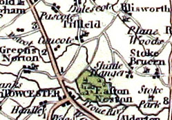
travellers Descote - see Snakemore below. Site of 13th century windmill and boundary 'marker' for the long perambulation of Whittlewood Forest. Great Way - this route branches from the Saltway at a place known as Mantles Heath, a few miles west of Farthingstone, and is referred to frequently, in terms of defining a boundary, in Charters for the Parish of Badby (944AD) and Stowe (956AD). The route can be identified with some probability as far as the Kislingbury to Rothersthorpe road. At this point the indications are that it headed directly to the Iron Age Hill fort at Hunsbury. The mapped extensions to the Fort on Hunsbury Hill and to Kislingbury are guesses and therefore expressed in yellow. Kingsway - or more correctly "King's Highway" which branches from the Watling Street just to the north of the River Tove bridge, North Bridge (Landmark No. 7). The present country lane follows the line. In the 1286 forest perambulations it was referred to and "the King's Highway leading to Northampton". It was presumably an alternative to the Oxenford Wey in travelling from Oxford to Northampton. It aligns remarkably well with the Roman traces of a road found in two places between the villa (Gayton) and Blisworth Arm. In other words the High Street of Tiffield could well have been Roman. A moot point is whether or not this highway was "braided" with the route assumed for Oxenford Wey, for example by a route across the fields between south-Tiffield and Duncote. London Road - the road via Horton leading to Newport Pagnall is known as the London Road. However, an earlier route for the London road was through Piddington but was extended to include Horton, for the convenience of eminent occupants there, when it was upgraded to a turnpike, presumably in the 18th century [1]. The track given on the map merely provides a reminder. Look Out - an interesting alignment of old buildings and a pathway suggest a straight path from the area near Blisworth Church Tower to the highest point on Gayton Hill, which is adjacent to the site of the Roman villa on the Blisworth - Gayton parish boundary. An account on this pathway, thought to be a Roman track up to a "Look Out" or a temple, is given on the Blisworth Website. Nunn Lane South - Nunn Lane is still present as a green lane that must have provided access to a number of fields in the south part of the parish. In Victorian times it appeared to terminate abruptly at the parish boundary with Shutlanger. However, after studying Shutlanger Grafton maps from 1727 it is very likely that the green lane continued into Shutlanger and aligned with Water Lane there. Thus a route is suggested; south from the turn in Blisworth on the Northampton road probably as far as Pottersbury. The traverse of the River Tove is conjectural. Before the turnpikes to Towcester and Stony Stratford, this route may have been significant. There is a little more detail in the Blisworth website article. There is a gazetteer on line compiled by Dr. S. Letters for early markets established in the country. Remarkably, this route passed by two markets: Milton Malsor (A market by Charter Tues; first 27 May 1305, by K Edw I to Edward Charles. To be held at the manor. A fair by Charter on Whitsunday first 27 May 1305, by K Edw I to Edward Charles. To be held at the manor) and Alderton (A market by Charter Thurs; first 26 May 1278, by K Edw I to Payn de Cadurcis. To be held at the manor. A fair by Charter Margaret (20 Jul); first 26 May 1278, by K Edw I to Payn de Cadurcis. To be held at the manor) thus strengthening the belief that the route was significant. A recent discussion (Peter Curran) has introduced the possibility, in the search for a south extending route from Northampton that passes 'between' the parishes of Easton Neston and Stoke Bruerne, that this trackway was once known as a Northampton Portway. Perhaps significantly, it carries four of the six Crosses listed in 1718. Far more likely is the possibility that "le Portwey" of c1290 was the main road from Northampton, through Hulcote, Easton and across the market place at Towcester - a late-Saxon road, part of the link established between the burgs of Oxford and Northampton. Nunn Wood Riding - Nunn Wood lies on the watershed between Ouse and Nene valleys. The riding cut through the wood is very nearly exactly aligned with the "Fort" circle on Hunsbury Hill, in fact aligned within 50 yards to the west of the fort circle. Perhaps the arrangement helped in signalling across Rothesthorpe Vale - but in what era? Oxenford Wey - this ancient route, a King's Highway in medieval times, thought to have been created by Offa (c600AD) to promote his expanding kingdom, has received very little publicity beyond being identified in the Royal Forest Perambulations (1298) as the western boundary of the Whittlewood Forest, with respect to the short perambulation. The perambulation cites route-points from the centre of Brackley, through "the vills of" Wappenham, Slapton, Bradden, and Duncote together with Burcote, Tiffield and then as far north as Snakesmore which we identify as the Gayton Wild (Fields) extending over half mile both east to west and north to south. The road has also been identified as "The Old Oxford Road" at Milton Ham [2], in terms of a traced line, so we must assume a plausible route to Oxford, following southwest from Bradden, in the mapping. It is also picked up in Wetton's guide and associated with the Roman villa (temple?) in Gayton, it being Landmark No. 3. Wetton's guide [2] also mention the route crossing the Watling Street by Duncote and heading northeast on the boundary of Tiffield parish. Eighteenth century maps give no indication of this trackway, from which we conclude it was superceded by other roads maybe as early as 1500, except perhaps near Milton and Tiffield. Recent work with the support of Lidar data on the Oxenford wey is reported in a separate article.
The date of the general disintegration of the Oxenford Wey (est. 600AD) which was eventually totally superceded by a 'new' road from Oxford to Northampton (est. late Saxon or c 1140) is yet to be clearly established (see previous paragraph). Population accumulation at the borders of the latter road were of course dominated by Towcester and the move to maintain it would have come from that town. North of the meeting field there is some confusion as to where the Oxenford Wey goes (there is a recent review of this situation). However, because of the references to the Roman Villa and the Milton Ham vicinity, the route possibly switched east along the Saltway for about a mile and then turned north. An alternative that is being pursued at present is that the route runs near the "Old Wilds" and traverses the flat Snakemore to New Wilds and thence to the area of the Villa. This detail will be presented with a separate map. A further possibility is that the route proceeded straight on towards Gayton and this results in a possible conflict when comparing the route assumed for "the old Oxford Road". Over the years, it is entirely likely that route braiding has occurred. The line marked with a ? mark is the one adopted in later documents on this website. The routes springing from a line through Gayton are discussed in the next section, as Options. Oxenford Wey Options - the options given are really no more than plausible extensions to the Oxenford Wey beyond Gayton parish. A route through Gayton and then Milton Ham subjects the travellers to a brook crossing at Lady Bridge (now is a part of the West Hunsbury suburb of Northampton) and the Nene crossing at South Bridge in Far Cotton, Northampton. The route through Gayton and Kislingbury includes the river crossing at Kislingbury. It is a few miles longer, however. The decision on which path to take is beautifully portrayed in this account of a journey taken in 1154 by a court entourage, written imaginatively but offered without sources, by Mr. Dave Blackburn (Duston) and placed on the Duston History website: The entourage left Westminster, via Bermondsey, Oxford, travelling north to Northampton, one of the regional seats of government . . . The royal party would keep to the high ground, crossing the Watling Street north of Towcester, with its floods, mists, and marshes to use the old Roman road via Tiffield, making for the Duston fords, or the bridge at Kislingbury. Since it was December, it was likely that the notorious river valleys of the River Nene at Northampton would be impassable. The only bridges of any age, today, are at Kislingbury or, on the northern arm, the Brampton Causeway, both many miles from Northampton. Reports reached the royal party, as they waited at the old meeting field at Tiffield, that access was indeed difficult. Even the new south bridge across Marsh Island was doubtful, so Kislingbury it would be. The crossing was without too much trouble, the large group proceeding over Kislingbury Bridge, along the north bank of the Nene on the Salt road via Upton . . . The entire passage is well worth reading but the implication here is that, at one time, in this case the mid-12th century, the route options in winter were important as was the meeting field for any considerable entourage. Portway - there are many 'Portways' as the name suggests a route to a market-place. The Portway marked here is highlighted a number of times in Wetton's guide book [4] and connects Northampton with the Hanslope area. In doing so it is very likely to be another extension to the Viatores Roman network - see [3]. Salcey Query - reported by a Forestry manager; a suspected Roman road on this line. It has been associated with the Salcey Stoneway because it aligns with part of it - hence confusion reigns. The situation is also confused by the fact that there is a disused pit at the southern end of the line and that pit had an access pathway, still a current path, heading towards Eakley Lane where there were other gravel pits. Furthermore, it may be significant that the location of this query road line does align with a 1791 line mapped for the Hundred boundary. Saltway - runs from Droitwich in an easterly (and slightly southerly) direction. Known as far as Blisworth Parish and dealt with briefly on the Blisworth Website. Information gleaned for Bridges History in 1718 confirms the Saltway near a limestone quarry in Blisworth. It also passed just south of the manorial fish pool. Notable is the fact that Saltways tend to avoid the large towns and this implies that, by tradition, the salt merchants must have had set points along the route for them to stop and trade; furthermore news of their arrival must have been "sent forward" in some manner. There is a little more to say about the Saltway - see the above section on the Courteenhall Road. Saltway East - an obvious question is 'where does the Saltway go east of Blisworth parish?' Two possible routes are offered and discussed on the Blisworth Website. Further hints are required, for example; if an ancient charter related to Ravenstone or Olney were to mention a 'Salt Toll' (as is the case for Litchborough - [5] which is on the well established part of the Saltway) then it would be clear that the more northerly option is correct. Saltway - others - a Salt Toll is mentioned for Upton (1329) - [6]. Clearly, this route running into Northampton from the west (ie. Droitwich) was used by salt merchants. Perhaps the Saltway was used for the part of the way, then the Great Way would have been used (ideas from D. Hayward), branching a few miles west of Farthingstone, and finally that would be parted in favour of a river crossing at Kislingbury. Snakemore - is evidently a vicinity to the south of Gayton, on the high ground, referred to in the 1298 Whittlewood Forest Perambulations and defined here with a green shading, which define the extent of the forest (law) by describing a counterclockwise path following the perimeter. After following the road through Tiffield and arriving at Snakemore, the paths around the "small" perambulation and the "large" perambulation follow different courses; the former runs south on the Oxenford Wey while the latter strikes further north-west before turning south along the lane through Pattishall towards Cold Higham. Snakemore is bordered by a relatively recently named region "Blacky More", being a field in the north-east corner of Tiffield parish, and by a place currently known as "Gayton Wilds" to the north. These names strongly suggest, together, a rather large area of waste ground in medieval times. Peter Curran (Stoke Bruerne) is convinced Snakemore is a meeting place for at least five roads; Saltway east and west, the King's highway running through Tiffield and the Oxenford Wey south and north. One might regard the last mentioned as dividing near Gayton to offer a road directly to Northampton or one towards Kislingbury. The boundaries, both short and long, for Whittlewood as interpreted by the text given in the above-mentioned link are lined finely in purple. Note that the long perambulation passes by "Dinscote" (where there was recorded a windmill in 1286 - one of the earliest?) and it seems likely that Dinscote is now the farm named Descote. Interestingly it is at Descote where there has been recently discovered, by the CLASP group, a Roman building of some note. Besides the topological aspects, Snakemore is interesting in that it was farmed in Roman times. This has been determined by the CLASP group, see article giving a little detail on the first of three Roman homesteads discovered in the area. Incidentally, the field name "Blacky" also indicates a Roman connection and approximately ten years ago a Saxon gold horde was discovered on its eastern margin. By way of a diversion; in 1900, two lovers, one in Eastcote and the other in Blisworth, exchanged letters with a promise to meet "up Gaton Fields". Both may well have used the Saltway path, one on foot, the other by bike. Stoneway - plotted by Forestry manager and stated by the head of Piddington Museum to relate to Victorian extraction of stone and/or gravel and not of Roman construction - see Salcey Query above. Said to run from Stoneway Copse to Madiron Copse, the latter copse has not yet been confirm by reference to a map. In the Stoneway Copse area there are many remnants of "pre-medieval earth works" some of which align with the line of the Stoneway. We are left wondering how old Stoneway really is.
* the bypassing route near Tiffield is more clearly shown on Bryant's map (1827) and can be traced in the existing bridleways in the area. Blisworth's award map (1808) and Grafton's rent survey map of Blisworth, dated 1838, both show that a 1 mile bypass was being considered from the (new) Railway Arch to the bridge over the Canal. It is thought this plan was introduced with the rendering of the road as a turnpike but resident tradesmen with businesses in the High Street would have strenuously tried to veto it. Blisworth eventually obtained an even better bypass in 2000! Viatores 172A and 172B - a wide swath of south-east Midlands was surveyed in the 1960s by a group who called themselves The Viatores. They published [3] and offered a mapping of all the Roman roads they could list. The roads and maps are numbered. Route 172A seemed to be aimed at the villa at Piddington whilst 172B is aimed at Blisworth, though the mainline railway works prevented them from getting further west than Ashton in their survey. If the more southerly option is assumed for the Saltway, east of Blisworth parish, then Knock lane in Blisworth is taken as substantially Roman in linking up with 172B. Hanslope has definite Roman connections; it has a Folly Farm, also a Cold Harbour and a Wick Lane [8] all three names usually found within 0.5 mile of a Roman route [3 - page 351]. References in the Text [1]
Wetton's Guide to Northampton and its Vicinity by E. Pretty (1849, repub.
1969) page 207.
|
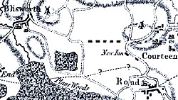 Courteenhall Road
- alongside this road on a 1825 map is a field called Greenway. In
Eayres map (1791) there is no route connecting to the
Northampton - Roade road near the Courteenhall estate gates, as there is
now. What is suggested however is a route, established many years
before, that passed Thorpwoods
and emerged in line with the Courteenhall parish boundary (this boundary
perhaps being the reason for the deviation). Interestingly, the
emergence of a presumably green lane coincides with a road
crossing on one of the lines that may have been taken by the Saltway,
see Saltway-east. In the inset, the dotted heavy line represents the present line of
Courteenhall Road. The fine dotted line, which is part of the
mapping, seems to suggest the Saltway; originating just north of
Tiffield, crossing to Roade at about the right place (for the more
northerly Saltway-east). The
alternative, and probably correct, interpretation of the line is that it
aims to represent the Hundred boundary (Wymersley and Cleley) though the
drafting is dubious.
Courteenhall Road
- alongside this road on a 1825 map is a field called Greenway. In
Eayres map (1791) there is no route connecting to the
Northampton - Roade road near the Courteenhall estate gates, as there is
now. What is suggested however is a route, established many years
before, that passed Thorpwoods
and emerged in line with the Courteenhall parish boundary (this boundary
perhaps being the reason for the deviation). Interestingly, the
emergence of a presumably green lane coincides with a road
crossing on one of the lines that may have been taken by the Saltway,
see Saltway-east. In the inset, the dotted heavy line represents the present line of
Courteenhall Road. The fine dotted line, which is part of the
mapping, seems to suggest the Saltway; originating just north of
Tiffield, crossing to Roade at about the right place (for the more
northerly Saltway-east). The
alternative, and probably correct, interpretation of the line is that it
aims to represent the Hundred boundary (Wymersley and Cleley) though the
drafting is dubious. 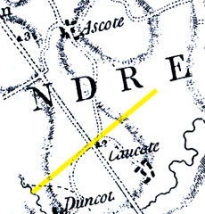 The above-mentioned Watling Street crossing is the route favoured
by S. Jowers and it is particularly interesting because it comes to a
small field that appears to be a meeting place (Landmark No. 4) right
alongside a Folly Farm with its Roman associations [3, page 351].
In Eyres map (1791) there is no crossing shown but there is
a turn off that bifurcates in favour of Caldecote (Caucote) and Astcote
(Ascote).
The inset shows the portion of Eyres that suggests the crossing
(suggested in yellow) was to
the north of Caldecote and hence the route very likely misses the centre of
Tiffield, see Kingsway above, indeed it skirted Tiffield parish (1850s
data) with the meeting field located next to Tiffield parish but
actually in Pattishall parish. Ogilby's strip maps (1674)
show no turnings but indicate an inn at just about the right location -
the "Man and Boy Bush". The Eyres inset seems to show
the 2 mile mark at the turn. From the centre of Towcester the
distances to the modern Caldecote turn, the modern Duncote turn and the
pathway assumed in the main map are 1.35, 1.80 and
2.10 miles respectively. A 1767 map of the parish of
Greens Norton shows a band of common land extended from the Watling
Street towards the centre of the village, bisecting Burcote from Duncott
(as suggested by the wording of the 1286 forest perambulation).
Clearly, Oxenford Wey passed through this common land but in 1767 there
was no trace of it shown in the mapping and no extension towards Bradden
was visible; the track had evidently disintegrated by then, leaving
vestigial traces amongst partial (and private) inclosures of that parish
(
The above-mentioned Watling Street crossing is the route favoured
by S. Jowers and it is particularly interesting because it comes to a
small field that appears to be a meeting place (Landmark No. 4) right
alongside a Folly Farm with its Roman associations [3, page 351].
In Eyres map (1791) there is no crossing shown but there is
a turn off that bifurcates in favour of Caldecote (Caucote) and Astcote
(Ascote).
The inset shows the portion of Eyres that suggests the crossing
(suggested in yellow) was to
the north of Caldecote and hence the route very likely misses the centre of
Tiffield, see Kingsway above, indeed it skirted Tiffield parish (1850s
data) with the meeting field located next to Tiffield parish but
actually in Pattishall parish. Ogilby's strip maps (1674)
show no turnings but indicate an inn at just about the right location -
the "Man and Boy Bush". The Eyres inset seems to show
the 2 mile mark at the turn. From the centre of Towcester the
distances to the modern Caldecote turn, the modern Duncote turn and the
pathway assumed in the main map are 1.35, 1.80 and
2.10 miles respectively. A 1767 map of the parish of
Greens Norton shows a band of common land extended from the Watling
Street towards the centre of the village, bisecting Burcote from Duncott
(as suggested by the wording of the 1286 forest perambulation).
Clearly, Oxenford Wey passed through this common land but in 1767 there
was no trace of it shown in the mapping and no extension towards Bradden
was visible; the track had evidently disintegrated by then, leaving
vestigial traces amongst partial (and private) inclosures of that parish
( Towcester
Road routes
- an old route between Northampton and
Towcester (with its modern A43 designation) passed over Hunsbury Hill,
then through the centre of Midelton (Milton Malsor), followed
Blisworth's High Street and the path indicated in red to emerge near the
church and Town Hall at Towcester. It was said to continue towards
Handley [7] - hence the crude tentative route lined in yellow. The
line is said to have been established c 1140 and near Northampton given
the title c1290 of 'Le Portwey'. A map drawn by John Cary in 1793,
see inset, appears to 'catch' the line of the Towcester Road in
transition as it joins Watling Street north of the North bridge (Landmark
No.7). Perhaps
the bridge across the River Tove near the church was compromised. Note
the river naming here
- Troue River, probably an error. The map also suggests, by the
drawn widths of the roads, that a way bypassing just south* of Tiffield was
the route favoured between Towcester and Northampton presumably for a
combination of reasons such as unreliable river crossing and obstructed
passage near Easton Neston. This aerial picture of the
Towcester
Road routes
- an old route between Northampton and
Towcester (with its modern A43 designation) passed over Hunsbury Hill,
then through the centre of Midelton (Milton Malsor), followed
Blisworth's High Street and the path indicated in red to emerge near the
church and Town Hall at Towcester. It was said to continue towards
Handley [7] - hence the crude tentative route lined in yellow. The
line is said to have been established c 1140 and near Northampton given
the title c1290 of 'Le Portwey'. A map drawn by John Cary in 1793,
see inset, appears to 'catch' the line of the Towcester Road in
transition as it joins Watling Street north of the North bridge (Landmark
No.7). Perhaps
the bridge across the River Tove near the church was compromised. Note
the river naming here
- Troue River, probably an error. The map also suggests, by the
drawn widths of the roads, that a way bypassing just south* of Tiffield was
the route favoured between Towcester and Northampton presumably for a
combination of reasons such as unreliable river crossing and obstructed
passage near Easton Neston. This aerial picture of the 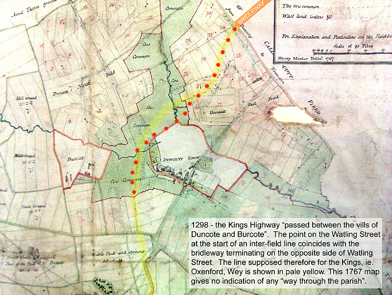
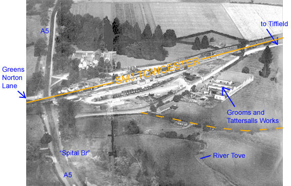