M300/NRO Notes by Wm. Taylor
of Heyford c.1718 for Bridges' History of Northamptonshire In order to collect information about the County, Bridges commissioned William Taylor of Heyford to visit each Parish and elicit answers to a set of questions. In this book, or part book, the questions are numbered 2.1 to 2.9 in a rather modern decimal manner. To one question the answer is "Nihil" ie. none, so it was necessary to inspect reports at other Parishes to discover what was that particular question. There were presumably other books dealing with issues that Taylor would have numbered 1.1, 1.2, etc. but there is no trace. In the columns below, Taylor's tabulation is reproduced with comments and links alongside. The decimal listing has been abandoned. There is a map below to show the location of the features mentioned |
|
|
Transcript |
Comments & Links |
|
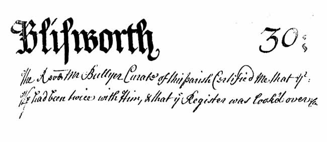
Blisworth 30 The Revd. Mr Bullyer Curate of this parish Certified me that we had been twice with him and that ye Register was looked over. |
Micro-fiched book - page
30.
This Rev'd was curate for only three years - hence the date of the visit was c. 1718. |
| The Farthest extent is from Thorp to Stoke Brewern Computed to be 3
Miles: Bounded by Thorp: Milton: Cortenhall: Rhode: Stoke Brewern: Shittlanger:
Tyffield & Gayton. Cortenhall lyes east: Gayton West: Thorp North: Tiffield
South: No. of Houses is 56, all inhabited:
The poor's houses are 6: Hamblett, or Innship, sw clo: is the Woodhouse & belongs to Mr Pickering of Bugbrook. |
Our
familiar Parish boundaries.
Population c. 250?
An inn called "The Woodhouse" with tenant publican Mr. Pickering ? See recent findings. |
| Seats: One, in which Mr Plowman now Lives & was formerly the dwelling house of Sir Robert Wake, who Owned the whole town: 'Tis now upon ye De of Grafton hold: | Over the door at Blisworth House is Plowman's 1702 date-stone. This Curate clearly thought Wake's residence was originally there. The last Wake was Roger not Robert ? |
| Church Lands: about 2 acres in each Field, in the whole 6 Acres, sett annually for about 50 and of long standing, supposed to have been Given by the family of the Wakes: | These are the Parish Lands, or part of, referred to in articles on Community Fields and History of the Church. |
| A Free School Given to this Town by the Wakes, Whose yearly Income Comes to about £10, It is given for the teaching of Latin as well as English &c, & ye Reverend Mr Bullyer ye present Curate is the headmaster: | The Endowed School was clearly run by the Church at this date. |
| Nihil | There are no other places of worship and there are no particularly notable possessions of the Church. |
| The Duke of Grafton owns the whole Town in
Generall, excepting one farm
House and a small Cottage: the Lord Leimpster & ye said De of Grafton are
Sole Lords of the Mannour:
The Lord Leimpster's Court being kept at Forster's Booth, which is for ye Game, for all Wayfts & Strays: At ye De's Court which is Leet and Baron, they put on their Officers, Choose ye Jury &c: 'Tis kept at this Town Twice a Year. The Reverend Mr Robert's of Rutland ye present incumbent, His Living worth about £100 p annum: |
No knowledge of this exception.
No other general reference to Lord Leimpster is known. He might have been an 18thC Northamptonshire "High Judge" as he held court also for Milton Malsor 'De' - abbrev. Duke Court Leets every 6 months. Rector Roland Roberts, 1701-1721 |
| Their procession is annual & on Cross Monday: Their Wake or Feast follows St John Baptist. | 'Feast Week', last week of June, has been marked by a short school holiday right up to the mid-20th century. Cross Monday is Rogation, a time for asking God to forgive sins and to bless the land, asking for the saints to intercede with God on behalf of the crops, livestock, and fishing. |
| Hills: 1. Cliff Hill: 2. South Gutter Hill: 3. Westbridge Hill: | Note this is Cliff and not Clift, the South Gutter is now known as Fisher Brook rising on Blisworth Hill.. |
| Parks: Formerly One, a place now called Blisworth Park: | Now divided in ownership. |
| Rocks: In this field is a Rock of good Red Stone; & Another of White Stone in a place called Salt-Way: | "Red Stone" - a good stone for building but not known for iron at this time. "White Stone" - limestone quarried near to either Pynus Cottages (see Pyesnest field) or Glebe Fm. ie. near the Salt Way. |
| Woods: One, called Blysworth wood, & affords every year a Sale: They have a very Large Common which enters Common with Rhode, called Blysworth Plain: | A northern part of the area was called Sale Wood. |
| Warrens: There was formerly One, but now totally Destroyed, still retains ye Name of ye Coney-Green: | This now being the Stoke Road allotment field with modern names of Connegar or Warren. |
| Brooks: One, which rises by ye Town's side from South gutt Springs, passes thro' this field on the South-West, drives an overshott wheel and thence runs for Milton passing on the west side, joins Lady Bridge, & then takes its Course for Upton Mill where it joins the River Nyne: | This
is the only known specific reference to the water mill located near the head of Pond Bank
road, put out of action in 1794 by the canal construction. [NB: for this entry, only, data from both the Milton and Blisworth tabulations have been merged in this compilation] |
| Springs:
1 Sow gutter:
2 Well Spring: both simple 3: is Ramwell Spring, a Mineral Water, & Accounted good for Sore and Weak Eyes: |
Sow gutter - ie.
the source of Fisher Bk. near to Nunn Wood. Well Spring - ?
in the vicinity of "Westbrook". Ramwell is the spring continually flowing across the park slopes into the canal at its first bend south of the mill. Its location well away from the village would tend to promote quality! |
|
The Road from Northampton to Oxford lies thro' part of this field: as also another from Northton to Towcester:
|
Not referred to as a turnpike.
|
|
The map referred to has been deleted, try the article on research instead - sorry for the cock-up. |
|