|
The Path of Oxenfordwey - Northampton to Greens Norton Tony
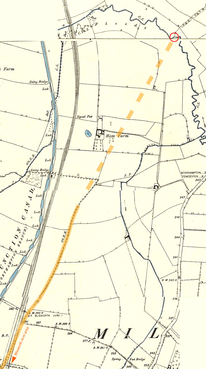
Marsh Sept 2015 INTRODUCTION A previous post here discusses the path of a number of ancient routes which pass near to Gayton. The Oxenfordwey is identified there as following the short 1286 perambulation of the Whittlewood forest leaving that forest edge somewhere near Brackley, heading for Oxford. Oxenfordwey certainly passes through the parish of Greens Norton (first mentioned to me by S. Jowers) and this fact has been recently supported by a Lidar survey. The path, it is felt certain, passes by a curious small square field (meeting area?) on the western edge of Tiffield parish and gains the high ground near Snakemore via "Old Wilds" and "Gayton Wilds". It was presumed to head north (with some easterly bearing to enter Northampton). The above-linked post offers some alternative speculative alignments for the path. This post aims to try and crystallise more. The path is referred to passing through "Blisworth Field" (William Taylor 1718) and this is interpreted as following the line of the Gayton-Blisworth parish boundary in the area that was to become Blisworth Arm. North of Blisworth Arm the line of "The Old Oxford Road" runs from Blisworth Arm NNE towards Milton Ham (as stated in the Wetton Northamptonshire Guide published c. 1870). The following three sections deal with the Oxenfordwey path, with as much Lidar support as is available from Far Cotton to Greens Norton. BLISWORTH ARM to FAR COTTON Not only is the path stated in Wetton's Guide to go near Milton Ham, it is also stated to pass by Lady Bridge which crosses the westerly running Wootton Brook. That bridge's approximate postion is shown in the map (a red ring) below that is based upon Ordnance Survey of c. 1899 and so includes the railways and field boundaries that were established c.1800 at the time of the country-wide field enclosures.
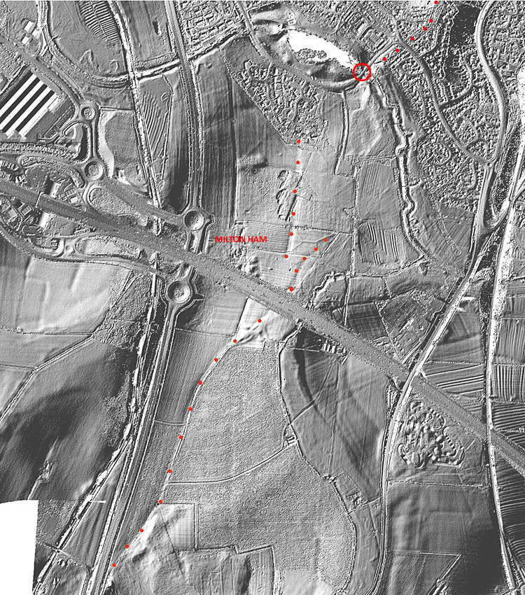
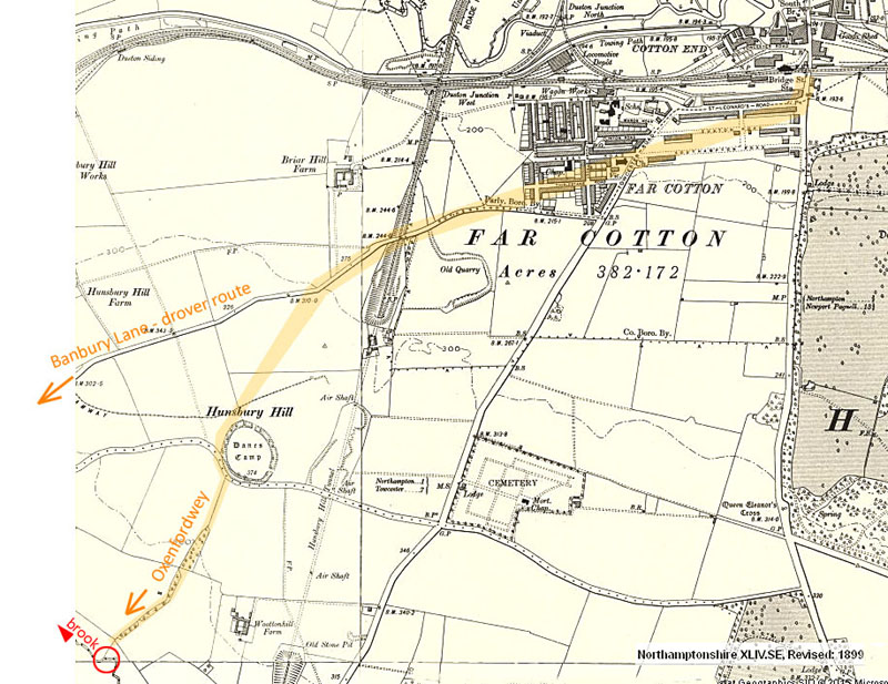
As will be shown in two figures hence, the line of the path is assumed to run in the very broad hedge shown in the upper-right corner of this map above. The next figure shows a Lidar scan for a similar area which adds some suggestions to the speculative dotted line in the above diagram passing Milton Ham in the direction of the Lady Bridge. In this diagram the suggested line (or alt. lines) are dotted in red. The ring is placed where the modern Lady Bridge has been built. A short distance to the NE of the bridge is shown, even in Lidar, the heavily tree-ed line of the broad hedge which in current times is developed as a leisure walk. The software used to generate the Lidar output (Global Mapper v.12) may also show height contours and these show that the pronounced northerly run (followed in red dots) lies on and follows a ledge of land with the level falling away gently to the east. The line eventually collides with an area of housing and little may be deduced regarding the details of the path there. To the east of the housing, the area is open-space for public leisure use and it may be assumed that much earth-working was involved in creating and seeding that area. The next section working northwards is not supported by Lidar because of unfortunate gaps in the coverage. The map below is also part of Ordnance Survey c.1899 and the line assumed for the path uphill from the broad hedge to the "Danes Camp" hill-fort ring simply follows an enclosure hedge line. Any alignment further into Far Cotton is impossible. It is said that both north and south slopes of Hunsbury Hill were once laid out with meadows that were used by drovers to store (and restore) stock awaiting a suitable day at the Northampton market. Once again the Lady Bridge position is ringed.
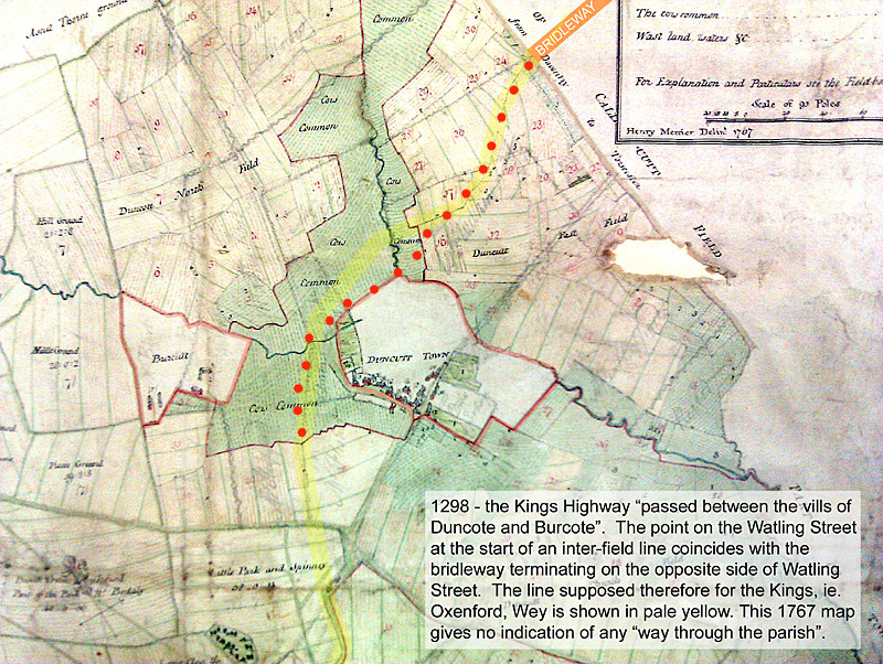
BLISWORTH ARM to GAYTON WILDS The map that can be opened in a separate tab shows the detail that is revealed by a Lidar survey of tile SP7154 which has an area of just 1 sq km centred conveniently at 471500, 254500 (marked "c" on the map). This brief account extends what was presented two years ago on the various tracks that run near the area that was known as Snakemore and referred to in the Royal perambulations, dated 1286, around Whittlewood Forest. In 2013 it was suggested that the track Oxenfordwey would run more-or-less directly from near Gayton Wilds to near Blisworth Arm. Various routes have been considered in the light of the only clues, until recently, in the form of 1780s field boundaries reproduced in OS 1899 mapping. Much of the terrain in the area has been badly disturbed by surface ironstone mining which occurred at a time mostly before the 1899 mapping. Affected areas are marked with "M" in the map. Most hedges have been lost. The map shows the 1899 mapping over most of the area that spans from The Wilds to Blisworth Arm located in an opposite pair of corners. The NE corner just includes the GUC bridge next to the Toll House with the new marina due south of that bridge. Lidar data, augmented with height contour lines (at 5 foot intervals), overlays the 1899 layer whilst some 1899 field boundaries are copied into an additional layer that lies on top of the Lidar layer. Thus it is evident that just two hedges have survived to present times in the NE part of the map. The Lidar rendering is based on light from the SE (141 deg) and so it is evident that the Oxenfordwey track, highlighted with a red dotted line, rides high (by a subtle amount, it must be stressed) upon the terrain. This was the case for a section of the Saltway near Salcey Forest and one assumes that the track has been strengthened by the addition of stones over the blue clay substrate. The track follows a gentle way across the contour lines and where the SMJ railway was built there is a pronounce long hump, which Oxenfordwey follows and which is cut through by ~3 metres for the rail tracks. The field to the north of the railway main line is particular flat in appearance because (a) it has been ploughed for ~20 years and (b) in 2005, entirely covered with canal dredgant to a depth of at least 6 inches. Across fields either modified with dredgant or mining the line of Oxenfordwey is a matter for speculation. I have adopted a path that is helped by scant clues. A dotted red line to the north of The Wilds aligns with the series of "avenue" furlong fields mentioned in 2013. This line, as well as the main one shown, run close to a spring. The two lines may be an example of "path braiding" over the centuries with road to the south being the latest braid-line for what is described in Wetton's guide as the "Old Oxford road" with reference to Milton Ham, just north of Blisworth Arm (as first mentioned in a general account of ancient routes, inc. Oxenfordwey but also covered in the section above). North of the spring, the line runs near parallel to a 1899 hedge line (which the farmer still 'marks' with differing crops) and parallel also to what appears to be a second hedge line some 55 yards to the east to the first. The kink in the "crosswise" hedge (extant) and the 1899 kink is near to this second hedge line, which (one is forced to assume) was created since the mining disturbance ~ 1890 - 1910. This vestigial hedge line extends to the south right up to the edge of the SP7154 sq. km. (and, incidentally, there is a second vestigial hedge line that is very long, slightly curved, that runs alongside the SMJ rail-track line) It is plausible that the area between hedge lines is yet another "avenue" furlong field created around the remains of an established pathway at the time of the enclosures, which in Gayton parish occurred in ~1780 at the latest. There is no sign of soil colouring or terrain profile, detectable by eye. A further supposition is needed and that is: after the mining, the "second" hedge was re-established and, at some point in relatively recent times, was again removed. None of this complexity would be necessary if it were not for the two facts, (a) that the "crosswise" hedge kink is so positioned and (b) that our proposed Oxenfordwey route appears to run straight along the middle of an "avenue". There is a gap in the "crosswise" hedge roughly where the supposed Oxenfordwey line intersects it. By looking north through this gap, the entire line of the route is visible in a gentle incline downwards to the barns at B. The other still extant hedge appears to run downhill to the west except for a short section adjacent to the road where it is level; through that level section the route is clearly shown in the Lidar data. So far, there has been no exception: a path shown up in Lidar has been where the ground is subtly raised, at least on one side, compared with the lie of the land nearby. Perhaps such paths are strengthened and any mud is lessened by adding stones - hence a raised level. The same applies to the Lidar survey (not shown here) for Greens Norton parish briefly discussed below. Continuing on the subject of 1899 hedges, the cross hedge a little to the north displays a sharp kink near to the Oxenfordwey track (near to the label "c"). This suggests an additional hedge that might have run parallel with the track. Also, the spring in the centre of the fields may have been fenced off and enclosed with a stretch of water that collects annually at the point I have marked with the letters "Lk" (a small lake). Farmers concerned with the welfare of sheep may have designed this fencing arrangement. The spring, by the way, is one of 6 marked places, within the scope of just this map, where water could be drawn up, all very close to the 400 feet (125 metres osl) line. The barn next to the road, evidently once equipped with a well-pump (P), is now demolished but acquired some fame as "Loundes Barn" that was frequently drawn and painted by the Blisworth artist Peter Newcombe. The Loundes area, with fields on both sides of the Gayton-Blisworth parish boundary, including the deeply grooved hollow, should be of interest to archaeologists as it is a locality offering water, shelter and a fertile soil to the north with iron-age refuse or burial pits to the south. GAYTON WILDS TO GREENS NORTON Lidar support is not available except for the parish of Greens Norton to the west of the Roman Watling Street. The first paragraph at this bookmark link describes the assumed path. The following map/diagram has been posted before but this time the path as indicated very clearly by Lidar is shown by the red dots. The stream crossing was thus revised.
|