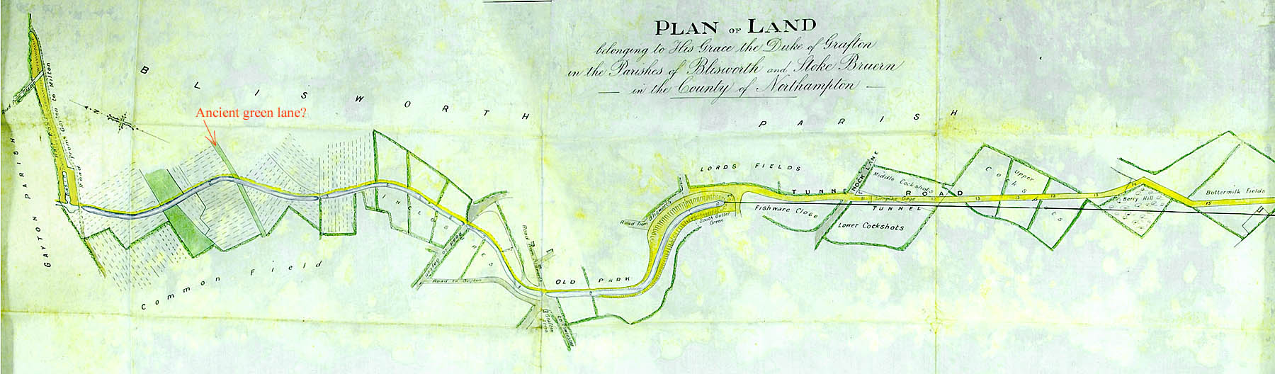
THE MAP OF THE TUNNEL ROAD, 1807
Buried in George Freeston's records is a photocopy of a map of the toll road built across Blisworth Hill which was initially intended to carry freight between Blisworth and Stoke Bruerne while the tunnel was being built. Some aspects of the map suggest it may have been a deposited map at the beginning of the project; the configuration of the roads which extend onwards to each village beyond the tunnel portals appear very schematic. Unfortunately the date of the map is not readable, because it was so damaged by damp, and the reference for the map in terms of its location in the NRO is absent. Recently the map has been found in the NRO as G 4133/2, probably restored to full colours in the recent years. The map was obviously drawn to indicate to the Duke of Grafton the acreage associated with different parts of the canal scheme. The very beginning of the Northampton Arm is shown while the over-hill railway is not. The map is in fact dated Oct 20th, 1807 and was associated with a conveyance for the land from the Grafton estate to the canal company.
The map is shown below - remember to use the scrollbars, both horizontal and vertical, to see at the features.
There are a number of features of interest.
1. We know the line of the Saltway as Knock Lane rather than Nock Lane. It is unknown how early the name was used but it does seem plausible as the original name since it could refer to notch-like oak trees grown for the main structural part of cottage gables; the lane at one time passed through forest. The award map of much the same date shows the lane as Plain Lane.
2. Near Knock Lane are a series of fields with the name "Cockshots". The name suggests they were somewhat wooded and used for catching woodcocks by stringing up nets. "Shot" implies a strip of field along a boundary, or comprising a boundary. The boundary could be the western boundary to the common land known as "The Plain" between Blisworth, Roade and Stoke Bruerne. Hence, to the east of the tunnel road was the un-inclosed common land and to the west, fields tenanted by farmers, eg Mr Wilson at Blisworth Hill Farm. Note also that the gamekeeper lived at Buttermilk Hall. By 1840 an Act of Parliament saw that all farm land was inclosed, though in Blisworth the Award was made in 1808 - 1815.
3. The map shows that the initial intention was to have a toll gate near to Knock Lane, see "Turnpike Gage". At the gate charges would be based on the weight of goods being carried, hence the need for someone to 'gauge (gage) the weights'. There were remains of a cottage near to Blisworth Hill farm, removed in 1976, which local lore suggests was the actual toll house and there is a photograph of this cottage in the NRO which was demolished in the 1970s. That the toll gate was actually near the farm location (not built in 1800) just north of Berry Hill, might be correct. The award map, however, does show a small vacant plot, to the west of the road, in exactly the spot marked 'gage' shown on this map thus suggesting its intended location - at least. Tolls would have been excised from roughly 1795 to 1800, the latter date being when the over-hill horse-railway was built.
4. The toll road, labelled the 'tunnel road', makes a detour around a field called Berry Hill. Hitherto, it has been assumed that the road was kinked to accommodate the somewhat kinked line of the horse-railway also known as the tramway or the hill railway. Conjecturally, the name 'Berry Hill' rings of an earlier corrupted name, namely Bury or Burial Hill being a place remote from villages where, in the years of the 17th century plague, the bodies of deceased could be more safely interred. At a time 130 years later, when the road was to be built, perhaps no-one was prepared to disturb that ground. This not entirely fanciful thought will not be welcome to the present farmer at Blisworth Hill farm! In one of George Freeston's notes he refers to there being once "three ancient tumuli at Bury Hill, the last surviving to 1985 when it was obliterated by ploughing". There is no indication where this reference was found and the above-mentioned map shows nothing of tumuli. However, Wetton's Guide to Northampton and its Vicinity, 1849, clearly refers to a significant tumuli whose form is part-obscured by waste from the tunnel excavation.
Read about some problems for miners sinking some of the pits for the tunnel.
5. Buttermilk field and its associated little cottage, Buttermilk Hall, was probably set up by the Duke of Grafton for his gamekeeper. By law, the line of the road was expected to follow closely the line of the tunnel and so the road would cut through the gamekeeper's field. It would be reasonable for there to be gated access across that field to allow the gamekeeper to retain animals - but only one gate is shown.
6. The line of the parish boundary is today much nearer to buttermilk field. The line of the road continuing to Stoke Bruerne takes a wider arc to the west before joining the Stoke to Shutlanger road.
7. It is interesting that the inclosures and the common field appear to have a boundary not far from where Station Road would come today.
8. Also interesting is the beginnings of the Northampton Arm as a little branch connected to a horse railway. The location of this little branch can be found today. Note that there are no buildings at all near there - Blisworth Arm as a hamlet did not exist in c. 1810.
9. Note also the prominent green band across the canal, labelled in red by TM, which seems more like an ancient green lane than a mere baulk between lands.
-------------------------------------------------------------------