|
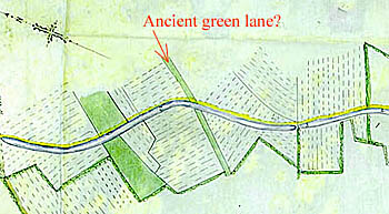
A Green Lane through North Field ?
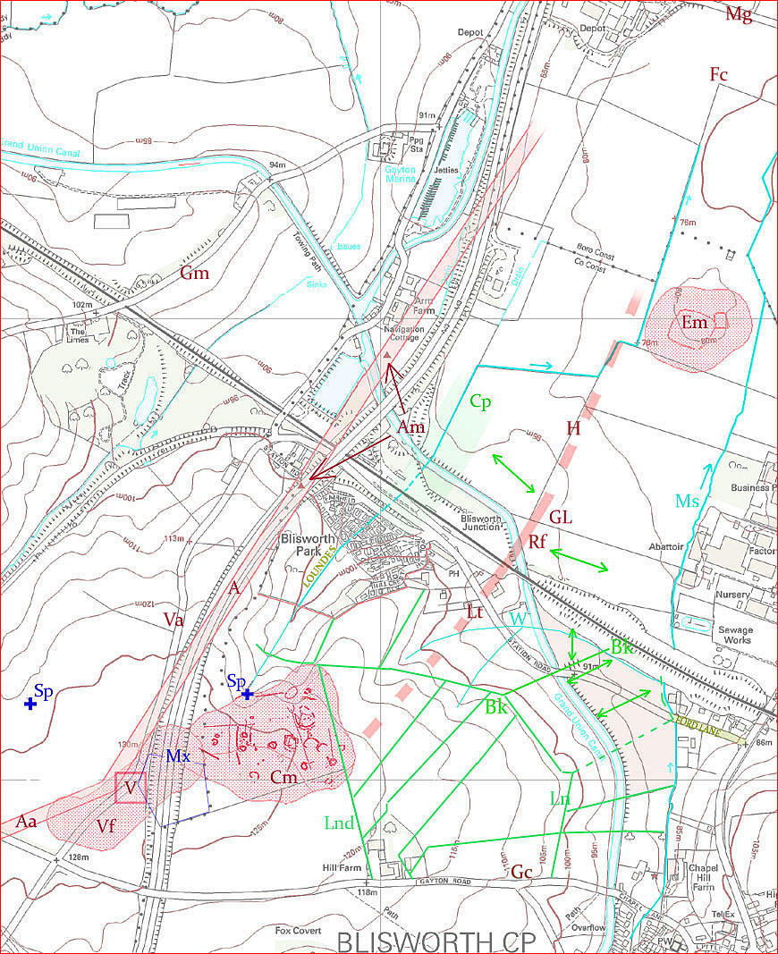
There is a comprehensive map a rather long way below on this page - click here for new tab for this map, if required. Tracks, baulks and waterways In the modern OS section below the green lane GL and the cow-pasture Cp are inserted based upon a successful fit of the 1807 map onto the OS map. The green lane is speculatively extended both to the north and the south to aid suggestions on what the green lane was used for. Also the direction of the ridge and furrow markings are transferred to the OS map as is the alignment of a baulk, labelled Bk at both ends, that divides a part of the field called Ford Close (shown pink). The ridge and furrow details for Ford Close correspond exactly with that seen today and this encourages one to insert a number of other baulks (or hedges) in the field to the west of the canal according to a layout shown in 1727 mapping. The point of these added baulk details is to show how the green lane aligns with known baulks to the south-west of the canal whilst the alignment to the north-east seem fairly obvious. The baulk Bk is important because it was the one considered to serve as a field road in 1794 and provoked the canal company to provide a small bridge for it over the canal. Perhaps at this location the lie of the canal in the field was level enough for a bridge. The bridge soon acquired the name Stockwell Bridge because of the prominent well W in the adjacent field. The bridge was soon rebuilt c.1840 with a new alignment to serve an extension to Ford Lane that became, in the 1970s, Station Road and built by Stephenson's railway company. The well W is now served from underground pipes and is drained by pipe joined to the mill stream at the culvert that passes under the railway embankment. When Ford Lane was established it extended only as far as entering the Close (see details) and this was at some time before the 1727 mapping. How it joined with the baulks is suggested with green dotted lines. Extending into the North Field were two water courses, namely the millstream Ms and the lesser one that drains from the spring Sp past the Loundes area. The green lane avoids both of these courses and this seems entirely appropriate in maintaining a dry enough surface. Note the small elevated patch of land on which, according to crop-mark appearance, was located a pre-historic enclosure Em (HER data). In medieval times this small hump would be a useful site for temporary folding of plough-beasts rather than walking them back to the village every night. To take advantage of the alluvial quality of the soil near the streams, one might expect a substantial use of grass land, cow-pasture etc., in the area of the North field, rather than ridge and furrow arable, and thus the green lane would have a role as a stock movement path. There are just a few key questions. Can the broad green lane be married into a medieval scenario? Could this lane have a local farming purpose at times before the medieval period? Could it be, instead, a part of a cross parish or cross country route? Comment is made against these three possibilities but there seems no conclusion with robust defense at the moment. We are left preferring a short medieval green lane with rather grand proportions! This is a feature that is not common judging from its presence in only three of the manorial maps in David Hall's book (The Open Fields of Northamptonshire), for Brixworth, Doddington and Mears Ashby. There is a comprehensive map a rather long way below on this page - click here for new tab for this map, if required.
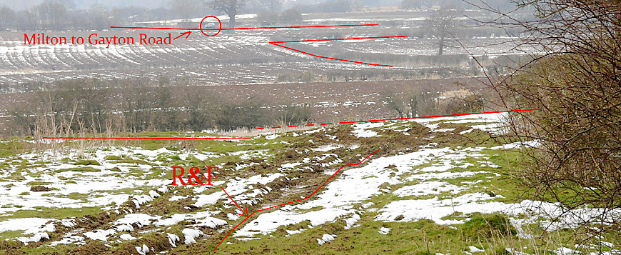
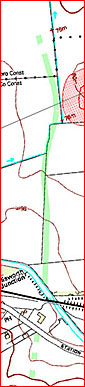
Regarding the north, one can see that the ridge and furrow patterns do indeed fade out at Rf. The photograph below, which was taken from the vicinity of Rf, shows a view along the western side of the hedge H, which is evidently pretty ancient. There is evidence there that the lane was indeed not on the western side (in grassland) because the ridge and furrow patterns closely approach the hedge. Unfortunately the field on the eastern side of H is arable and conceals any sign of a path that is clearly shown was there in 1808. In the photograph there is an indication that the lane once reached as far as the Milton to Gayton road at the point where a car (ringed) is parked at a broad field gateway, at Mg in the map. Before c.1980, the parish boundary coincided with that road and with a section of the mill stream. The red chevron outlines the field corner at Fc and the possible vestiges of the lane is suggested by the snow patches running up past a substantial oak tree towards Mg. In fact the award map shows the green lane extending only about two thirds of the way to the road before petering out as it gradually broadened to over 40 yards, in other words the lane ceased in the vicinity the ground's lowest level. Thus the 1808 limits of the green lane seem clear enough and sensible in a feudal context. Did the lane once reach significantly further distances? The inset to the paragraphs above shows the extent to which there are notable residues of the green lane visible in the DSM (Digital Surface Model) imagery from Bluesky-World. The green markings show a rather wavy course for the lane whilst the strictures of the 1820s inclosure field demarcation overlay it. It is evident that the lane picked up and followed the low-lying ground and perhaps remained as not only a conduit but also a piece of watery meadow, or common cow pasture, that could not be otherwise cultivated ie. in support of the outlines in the award map. There is no evidence in the DSM data for an extension to the lane either to the south or the north of the indications in the inset map. However, because of the severance of the north fields from the village by canal and railway in the early 19C, we know there must have been access to the northern most fields from the Milton-Gayton road. DSM data show a vestigial hedge line coincident with the oak tree but it is not clear to which side of that hedge the access track once went.
Although there is no evidence of extensions to the lane either to the north or south the possibility of it in a pre-medieval context is discussed below. For Local Pre-medieval Farming? One's attention is drawn to the HER data for a complex of crop-mark features Cm on the high ground. There are a number of aerial photos of these and some time ago one of the circular features was explored by digging (see HER notes) with the impression given of a stone lined pit in which were a number of animal bones. Linear features were described as ditches. That the features arose from pre-historical activity is definite but no-one dare say there was a settlement at that place. For a settlement the location would in fact score well (a). on defense as, from a nearby point Mx, one has an unhindered 360º view, (b). on a good water supply Sp nearby and (c). on well-drained land nearby for cultivation and scrub on the slopes to the north that would have provided building materials. Also possibly relevant is the Roman villa/temple at V, discovered in 1840. In the map it is encircled by a pink HER 'embrasure' Vf that covers most of the Roman finds nearby. Also Roman was the road metalling found at Am; two sites that if joined and extrapolated seem to show that the villa was probably accessed from the north-east. A south-west extension, eg. Aa, is discussed in the next section. Near the villa, the parish boundary (shown by dots) cranks around a pentagonal little field, see fine blue lines, on the Gayton side. Aligned with the crank in the parish line there was a baulk that ran up and joined Lnd. This baulk was rather less perfectly aligned in 1808 than indicated in the modern OS map. Perhaps the green lane followed that line anyway and passed near to the villa. If so then maybe the idea of a Roman green lane running from a Roman farm/villa down to the valley of meadows has some credibility. Note that the new A43 has taken away, in its cutting through the hilltop, any possibility of further exploration of this area. Furthermore, any remains of a green lane alongside the pre-historic features has probably been obliterated by the 19C and 20C ironstone open mine workings. Part of a Longer Range Route? To judge feasibility we could compare routes according to their worst grades that would be involved climbing onto the high ground near the villa from either the Vale of Rothersthorpe or the valley in which Blisworth is situated. The easiest grade of about 1 in 15 is offered by the Blisworth - Towcester road, next easiest are the "Villa" Lane Va and the Courteenhall - Gayton Lane Gc at 1 in 10. Our 'new' candidate would have suffered a grade of 1 in 6 or 7 but apparently so did the Roman road A ascending from Blisworth Arm. Other factors which count against this green lane having been significant are (a). no soil-marks have been noted, (b). the route is very close to a minor run-off valley and (c). as mentioned above, there is nothing apparent in the DSM data. North-south connections that have been sought in the past are (i). the "Oxenfordwey" (an Oxford to Northampton route prior to an establish route via Towcester and close to Brackley) and (ii). the "Kings Highway" from Towcester to Northampton via Tiffield. Both of these routes are referred to in the 1286 Whittlewood perambulations. The former one is also known as the Oxford Road, picked up near Blisworth Arm in Wetton's 1849 Guide. A good deal of this is discussed in another article on this website and, to be brief here, our new green lane does not have much to offer other than, to the north, it could satisfactorily link through Milton Ham to Northampton and, in so doing, circumnavigate Blisworth Arm. It is important to note that the 1718 preparation for Bridge's History includes a reference to the Oxford Road passing through "this (Blisworth's) field" but a detailed attempted alignment for the road places it passing through the very edge of the parish. Unfortunately there is no scope in exploring the line of the lane on the north side of the Milton to Gayton road because of extensive 20C sand extraction and in c.1800 (Milton award map), before any extraction, there was no suggestion of an extension of the lane into Milton parish. Because the Oxenfordwey must pass through Greens Norton common (as stated in the perambulations) it cannot reasonable pass through Tiffield and nor may it pass near Towcester. To the south west of Watling Street the 'battle of the routes' for Oxford must have been won by the "A43", over the Oxenfordwey, in early medieval times yet, nearer to Northampton, it is noted in Wetton known locally as the Oxford Road, still then extant but only just. The status of the Roman road A is unsatisfactory because of a lack of data. The HER references quote the two metalling find spots and infer a route that would serve as a fore-runner to link Northampton to Towcester and, in so doing, would pass via Hulcote, it is suggested. But the alignment is for Tiffield, with a likely meeting with the Watling Street at Spital Br., so the natural assumption would be to continue the route over the crossroads to the south of the villa, crank the route onto the Saltway aka. Salt Lane* (west) and crank again (south) onto the King's Highway for Tiffield. Alternatively, the necessary cranks might involve using route Aa to the vicinity of the Gayton Wilds cottages and then, as one option, a direct step across Snakemore and thus into the King's Highway. That direct step is labelled the 'Road to Towcester' in a 1791 map of certain fields** in the parish of Gayton. Another option would be to traverse Snakemore to the vicinity of the "Old Wilds" and follow into Oxenfordwey (this alignment is explained in a map being prepared in August 2013). Because of 19C mining disturbances there is no way the alignment Aa can be substantiated - other than by the fact it aligns with paths for a little of the way. To follow this discussion the reader is referred to the map that can be opened in the "routes" article. * this is the first (and only) pre-20C Northamptonshire reference to
this Droitwich saltway The "Villa" lane shows a fair amount of hollowing that indicates use over a considerable time as does the King's Highway as it descends into Tiffield. In a 1791 plan of the "Lowndes" fields in Gayton parish, the Villa Lane is described as the public market road to Towcester, the word 'public' implying it was toll free. It seems unlikely that the green lane under discussion here would have made a connection onto the Villa Lane.
|
 Medieval
Relevance? One cannot help be struck by the width of
this lane. For a connection to the south the key baulks were Lnd and Ln - both by
1727 developed into trackways, the former of which acquired the name
Loundes Lane and is still extant. Even though it was recently
decorated with wind-driven snow, the field topography near to Lnd
revealed nothing of interest. This is not surprising as the arable
farming cycles in that field over the past 45 years have totally
obliterated any ridge and furrow patterns. The 1808 Blisworth award map shows the lane
in fact terminated at Lt in a complex arrangement of tiny
paddocks perhaps for stock holding (plough-beasts?) with a convenient
well W nearby. Note that there was no road near to that
location before c.1840.
Medieval
Relevance? One cannot help be struck by the width of
this lane. For a connection to the south the key baulks were Lnd and Ln - both by
1727 developed into trackways, the former of which acquired the name
Loundes Lane and is still extant. Even though it was recently
decorated with wind-driven snow, the field topography near to Lnd
revealed nothing of interest. This is not surprising as the arable
farming cycles in that field over the past 45 years have totally
obliterated any ridge and furrow patterns. The 1808 Blisworth award map shows the lane
in fact terminated at Lt in a complex arrangement of tiny
paddocks perhaps for stock holding (plough-beasts?) with a convenient
well W nearby. Note that there was no road near to that
location before c.1840.