|
Blisworth Mill-Stream Detail |
|
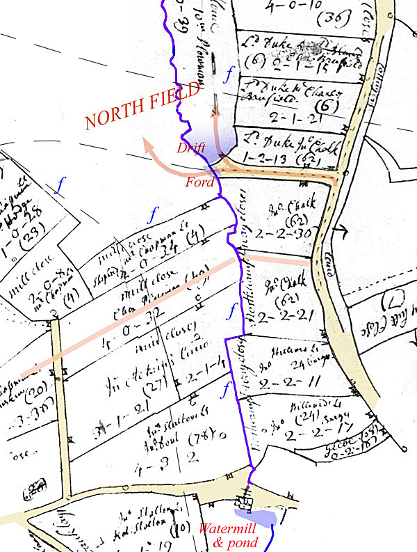
* The origin of Ford Lane, ie. in relation to
Cromwell, was explained to my partner recently and after careful thought
I was asked why I had never studied a more practical skill such as
ironing.
|
Present day centre-lines are shown in dashed
narrow lines for the railway, Station Road and the Canal, as a visual
guide.
Date of map is 1727 by which time the inclosures due to Cromwell in 1649 had been consolidated into various farmers' and villagers' plots. A substantial 'feudal' open field, North Field remained. Tracks and roads are shown in light brown. From the Northampton road is branched 'Ford Lane' which appears to have existed simply for access over a ford to the North Field*. The lane may have taken the line of an earlier baulk. Field boundaries labelled with 'f' are thought to have been fenced in 1649 and probably remained so by 1727. It seems likely that the area between the 1649 inclosures and the stream, in the north, was left in the open field at first but was, by 1727, assigned to a prominent farmer (W. Plowman). Earlier than 1649 (or maybe a considerably earlier date), the area to the south of the North Field was also open field and the alignment of the strips and lands are revealed by the field boundaries - see pink guide lines. Interesting is the fact that by 1727 the earlier inclosed area had been subdivided into many units ranging in size from 1 to 4 acres (see the inclosures article) with a popular size being 2 acres. The reasons for this are to be discussed elsewhere but it appears to reflect a need for part-time farming. Fields names beside the mill-stream indicate much larger fields originally; Mill Close to the west and Northampton Way Close to the east. Large fields became the rule again in the 19C with the final inclosure Parliamentary Act. The water-mill building is shown as a single ridge with one chimney and with a door to the north. It is fair to assume that early 18C mappers aimed to depict buildings faithfully. The mill-stream emanating from the wheel is shown aligned with the centre of the building and passing under a small bridge. Hence it is assumed the wheel was inside the building. Although the pond was once extensive we know it was considerably reduced by 1727 as is approximately shown in the map. As recounted elsewhere, the action of cutting and straightening the mill-stream so that it could be fence efficiently would be likely to have resulted in 'loss of direction' for the water once emerging into the open field, hence the drift and the creation of two branches to the stream, for safety's sake, by railway engineers in 1835. |