|
BLISWORTH - THE EARLY YEARS This article lacks historical
'meat' but is nevertheless offered to |
|
In the vicinity of Blisworth there were Roman towns at Towcester and Northampton. Apart from these two towns there were little more than villas or farm houses at intervals of half to one mile. The nearest villa to Blisworth was that discovered in 1840, located at the highest point on Gayton Hill. We know of nothing of any settlement, at any time before the Domesday survey, in the valley that is now occupied by Blisworth. However, there is a little valley running north from the site of the Roman villa with a row of fields named "Lowndes". The name derives from Old Norse lundr. The word means "wood or grove" and often has a sacred significance. Maybe this area was the centre of worship, with the villa actually being more likely a temple (they are often indistinguishable) and its site remaining significant for 500 years. Part of the name Blisworth may derive from the Danes too. The name of the village may well have originated in something of a generic - happy healthy homestead which is by no means rare in England for example there are many River Blythes with names of villages nearby that seem very familiar (Staffordshire, Nottinghamshire, Northumberland, Scot. Borders and Suffolk). Also blyd in Shetland dialect means 'glad' and blyth in Orkneys dialect means 'well-being'. Perhaps the Englisc (OE) name for the village was Leahworthe (cleared at edge of woods) but was altered to Blythesworthe circa 900AD, because of its charm, ie. its sheltered location, abundant springs and building material, a stream and perhaps, then, over a hundred good acres. There is no doubt Blisworth was taken over by Danes - there is a Thorpewood 1 mile from the village centre. Domesday
Record: William
Peverel also holds 3½ hides in BLISWORTH. Land for 9 ploughs A freely Anglicised and extended version of the
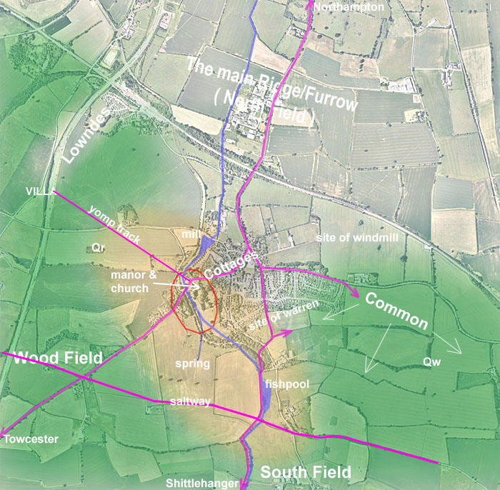
Domesday entry, 1086, follows: Being a son of William the Conqueror, the "knight" William Peverel owns many estates in England. However, in this County, he holds four manors, one of which is at Blisworth [Blidesworde pronounced 'blithesworth']. Within his own farm there are 220 acres which are cultivated with 2 ploughs (ie. in Lordship). There are some 200 acres more of his holding of which nothing is said - not ploughed (too steep, too wet etc. else probably woodland). There are 12 common villager households and 6 small-holder households and, between them all, they have 7 ploughs on a total of 450 to 550 acres - making 9 ploughs in all. "Ploughs" may be expected to correspond to an average of 6 oxen provided by the tenants, ranging from 2 to 8. There is a mill on a small stream valued at 2 shillings per year. There are 4 acres of common meadow and one and a half square miles of common woodland - this being a considerable 960 acres and it would include the woodland within the Lord's holding. The conversion from the Domesday record to modern units requires skill - G. Hatton (Kilsby), medieval expert, helped considerable here. The population, based on 4 per household, would have been about 80 people. The acreage assumed for the villagers, defined as a number of ploughs, depends on the quality of the land which will generally be considerably poorer than the land in the Lord's farm. The previous owner of Blisworth, Gytha of Hereford also owned Courteenhall and Collingtree and various other parishes near Nobottle according to one "Domesday" website. Gytha (1025 - 1099) was of Danish stock, the daughter of Sweyn Godwinson (1020 - 1053) who in turn was a son of Earl Godwin of Wessex (990 - 1053), the powerful brother of King Harold II who lost to the Normans in 1066 at Hastings. Blisworth might have been a back-water but there is no doubting its Danish royal heritage of 1000 years ago. Gytha was a common name, there was also a Gytha of Wessex, one of many daughters of Harold II. One suspects a scholarly study of the Danish Royal family 900 - 1066 might be needed to ascertain Blisworth's ownership for certain. The area of the current parish of Blisworth is 1881 acres (SNC data) and it is bounded by the parishes of Tiffield (to the west), Gayton (northwest), Milton Malsor (north and north-east), Roade (east) and Stoke Bruerne with Shutlanger (south) and all these are also Domesday recorded settlements except for Gayton. However, at the time of the Domesday survey, in 1086, the area was reckoned up to total ~1500 acres. This includes the undetailed Lord's 200 acres. A feudal model under the Normans would doubtless develop with time but it must have been traumatic for the villagers when William Peverel arrived and took over all the best fields. We know that Blisworth eventually enjoyed considerable common-land which it shared with Roade and it seems that systematic wood clearance on Blisworth Hill (maybe also adjacent to Tiffield - Wood Field) provided that area. It also is likely that Blisworth would have benefited from rights to keep many swine and run them in the wooded areas. The map below indicates a possible distribution of the classes of land. In light orange, 200 acres of the Lord's land and shaded green, woodland. Encircled in red is the suggested pseudo-military enclave with the village, the water mill, and the fishpool all quite nearby. The water course is indicated (well before any canal development). Whether this little stream on which a mill was located was called Blythe or Blide is not known - the earliest record is for 1718 when it was called Sow Gutter or South Gutter (later Wash Brook, Winter Brook and Fishweir or 'Fisher'). The area of villeinage cultivation (that which is not darkened) has been chosen with much artistic license/guesswork. The location of an enlarging common land area is indicated with some reasonable certainty, indeed the use of the King's forest for building materials fuel and fodder (incl. acorns at the right time of year) would certainly have been agreed on account of the minimal area of common land. Whether the enclave had significance at an earlier date than 1086 cannot be stated but the occurrences of good spring water and a helpful topology for defense does promote that idea as being relevant perhaps at Roman times. As terrier records are scant there is little evidence of a three-field agricultural system being used in feudal times, however a two-field system at least, with South and North field, seems obvious. It seems likely that Blisworth would be isolated from neighbour settlements by a margin of scrubby wasteland or woodland. It is suspected there may have been a hamlet at Lowndes as mentioned above. That area has both Roman (ie. the villa/temple) and Iron-Age connections. To the northern lowland, the woodland was probably sparse enough to have been cleared. The soil is generally adequate on sand or gravel sub-bars created by some giant river in the vale. Where land rises, as it does in the other directions, the woodland would be likely to consist of heavy timber such as oak and elm. The density and impassability of the woodland would be very variable and in some places only a coarse grass and a shrub such a gorse may have become established. Archeologists find great difficulty in determining whether certain tracts of land were woodland in pre-Norman times. The clearance of the 700 acres of mostly lowland by the farmers who were enslaved to Gytha, the Anglo-Saxon lord before the Conquest, would have taken very many decades if not centuries beginning at first with one or two families attracted to the shelter of the valley and the water. In fact, one can easily picture a period going back over 9,000 years in which the valley was settled, wiped out and then re-settled through many cycles as a Neolithic farming style was replacing a hunter-gatherer living style. Good tracks, at least in dry periods, connected the settlement to early Northampton and Towcester on the line of what was probably a road built by Romans who expected the enslaved Britons to use those roads to market their produce. The other tracks may have been little more than green lanes. We have no idea how busy the cross-country track called the Saltway would have become by 1086. Its easterly progress through the forest could have been well maintained if it was required to provide access for heavy timbers (as a later name of the path suggests - Knock Lane, a 'nock' being a heavy natural forked timber useful in timber-framed house construction). A military yomping track line has been suggested by the straight-line coincidence of a jetty near the Sun, Moon and Stars Inn, a path across a field and the highest point on nearby Gayton Hill. It might have been a Roman military requirement to have access to a lookout over Rothersthorpe Vale. It would certainly have been a good idea during the troubled times while the boundary of Danelaw was being established. |
|
|
|
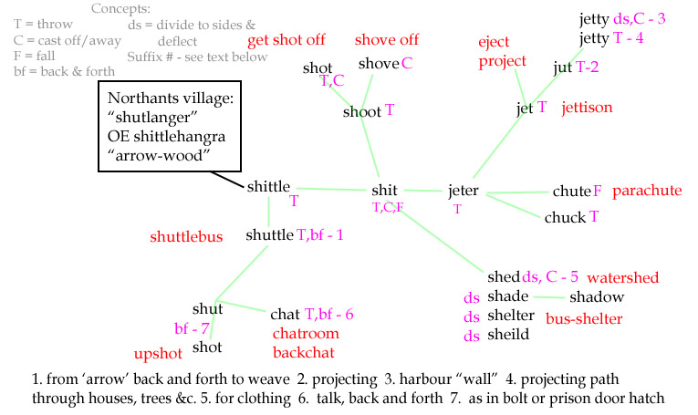
The enclave area is merely suggestive - within there would be a special enclosure to accommodate encamped armies, gardens, bathing areas and sports such as hunting practice. At a closer perimeter there would probably be some timber fortifications. The manor house and some associated buildings close-by were probably located on the ironstone bluff now occupied by the church. At the time of the Norman conquest there was probably no Christian church - more likely there would have been a wooden Anglo-Saxon assembly house. The commencement of a stone church, and later its bell tower, would have a dramatic effect on 'locals' who knew how to build only in wood. The incoming masons certainly obtained their stone from the Northampton region, judging from the type of limestone and the ironstone content of some blocks. However, there is little evidence of a likely quarry location. The map is marked Qr (ironstone) and Qw (limestone) as likely (worked-out) sites where the stone would not have been at considerable depth. Local historians have guessed otherwise, placing an early Qw in Wood Field. It cannot be stated with any certainty how much of the resources enclosed in the manor lands had been established at the time of the Conquest, further than the use of the spring and the water mill. At least, we know that the establishment of a warren was granted to Thomas Wake in 1315. Much of the general area had been Royal Estates (Crown Land) but in the interregnum c. 1650 much of the Blisworth parish was bought by upwardly-mobile families (Brafield, Plowman, Crane and Tibbes etc.) who were forced to revert to tenantship by 1705 as the Lands were taken back by the Crown and were later subsumed into the Honour of Grafton. The area taken by the interregnum freeholders remained inclosed lands; the full story of inclosure in Blisworth parish is given here. The paucity of detailed records before c1700, apart from the interregnum sale documentation, is unfortunate and means that we have no way to show the development of the village until after then, by which time the millpond was severely silted and the ancient quarries were almost certainly disused (the sites appear farmer-cultivated in the 1729 survey maps), the fishpool had been drained and the Manor was occupied by a Grafton tenant (W. Plowman). At some point a windmill had been established, possibly as early as 1300 since we know of the existence of one near Pattishall in 1298. The parish population had risen to about 250 by 1700 and by then much woodland had been cleared and forthwith inclosed. In c1685, for reasons not clear, two fields on the Tiffield parish boundary were assigned to the Blisworth rector; "Pyesnest" ie. magpie's nest and "Oxhay". Oxhay, a boundary field useful for overnight resting of oxen, became "Wolsey or Wolfey", obscurely, and the other name degenerated into "Pynus" and became the name of a small group of Victorian cottages on the Towcester Road. The 4 acres of common meadow continued as "The Green" but in 1798 it was excavated for the entrance to the canal tunnel. The name 'The Green' persists as the local address for the twin thatched cottages at the edge of the village on the Stoke Road. By 1838 the warren had been converted into villagers' allotments. The spring that is highlighted is that known as Ramwell Spring (1718), later called Rannell (1935). Another spring known as Well Spring was located near the village centre - there were probably many others. Many of the stone and once thatched houses at "Townend" (Northampton Road), in the High Street and in Stoke Road were built in the early 17th century (see account of listed buildings) and is evidence of a major rebuild period in the village, again well before the availability of records. The nature of cottages before 1600 can be surmised by comparison with other Northamptonshire villages as a mix of stone and timber-based with much use of wattle/daub for inside walls and even some of the outside walls in the more modest of dwellings. Wattle interior walls have been preserved in one house at Townend. Many 17th century cottages have a very substantial "ground plate", which, along with a few lower courses, are built with a striking dark red/brown ironstone. This base might have been a start for the rebuild in the early 17th century - maybe an expert could comment. That feature of many cottages implies a medieval source of ironstone. It might have come from the site marked as an 'outcrop?', ie. at Qr, or possibly from the edge of the ironstone bluff notable near either the present Old Rectory or the Baptist Chapel. There are snippets about the development of the Manor of Blisworth in the Victoria History of the County. Mona Clinch has efficiently extracted some salient details. Apart from the general impression that Blisworth manor seemed to be a rather 'sought after' asset there is, in fact, little to indicate its development. What there is has been italicised and coloured. From M. Clinch (1935) extracted from her booklet, however "British History On-Line" now offers the complete account. At the time of the Domesday Survey William Peverel, the Conqueror's natural son, held 3½ hides in Blisworth. On his death in January 1114 the land passed to his son William Peverel, who held at the time of the Northamptonshire Survey. He forfeited his lands for treason, and at Michaelmas 1157 the King granted to Robert de Peissi land in Blisworth and Newbottle of the annual value of £43. In 1181 his son Robert held Blisworth, but the next year he was succeeded by William, son of Robert. In 1189 Richard I granted the over-lordship of Blisworth to his brother John, Count of Mortain, who held the Manor until 1194 when the King resumed possession of the Honour of Peverel. At that time Mathew de Clere held New-bottle and Blisworth, of the yearly value of £43. In 1199 the King granted to William de Ferrers, Earl of Derby, the grandson of Margaret, heiress of William Peverel the younger, the overlordship of the hundred of Higham, Blisworth and Newbottle, in return for the payment of 2,000 marks. It was around this time that the name given would have actually been Blisworth - before that a name sounding like Blithsworth would have been common. Isabel, widow of Robert de Peissi, sued the Earl of Ferrars for these estates. The case was dismissed as Isabel had no right in the land except by her husband, who had it by grant of Henry II when the Honour of Peverel was in his hands. William de Ferrers died in 1247 and was succeeded by his son William, Earl of Derby, who died in 1254 leaving a son Robert, who was born in 1239. He received livery of his lands in 1260 but forfeited them six years later when the Honour of Peverel was granted to Edmund, Earl of Lancaster, and became incorporated in the duchy of Lancaster. William Earl of Derby granted the Manor of Blisworth and the advowson of the church to William Briwerre, to be held as half a fee, the grant being confirmed by King John 1199. The next year Briwerre was given leave to assart, ie. grub up, 60 acres of woodland at Blisworth. In 1212 he was granted timber from the forest of Leicestershire to build a cellar and chamber at Blisworth, and the following year had a license to cultivate 30 acres more woodland, quit of the regard. In 1220 he was granted 24 trunks for posts and squared beams and two crooks from Salcey Forest for rebuilding his houses at Blisworth. This last may have been cropped out along Knock Lane, since crook and nock mean the same. On his death in 1227 the Manor descended to his son William, who died in 1232, Blisworth being allotted to his widow Joan in dower. The next year the Manor was assigned to William de Percy in the name of his daughters, the co-heirs of a fifth of the property of William Briwerre. Joan seems to have retained possession of the Manor, however, which descended on her death in 1205 to Sir Baldwin Wake, the grandson of Isabel de Briwerre, sister and co-heir of William, and wife of Baldwin Wake of Bourne. He took part with the barons against Henry III, for which offence the King granted his Manor of Blisworth to Alan Plugenet, who held it in 1266. Sir Baldwin probably redeemed it under the award of Kenilworth, and held view of frankpledge and other privileges there in 1276. The further history under the Wakes until 1540 and the subsequent handing to Henry Fitzroy the, by then, extended Honour of Grafton is accounted elsewhere. During the commonwealth of Cromwell's, 1649 - 1660, land in Blisworth was sold to various individuals which spurred on the inclosure of the common fields. Of the many owners of the Manor mentioned above it is not known which of them actually lived at the Manor house for significant periods, other than the Wakes who lived there for 258 years. Given a considerable skill in reading ancient manuscripts, lots of spare time and free travel passes to London, Peterborough and Lincoln, it might be possible to significantly add to this record - but I pass on all counts! Perhaps one can do little better than to absorb current opinions on the emergence of Britain for a background. I have copied here a review of a new book by Barry Cunliffe - food for thought. Tony Marsh September 2008, revised July 2011. * addition in December 2014 on the topic of Old English and the relationship in phonetic terms between a whole panoply of words - see the layout referenced here - cf. derivations in Oxford English Reference Dictionary. |