A
Historical Tour - Blisworth
to Stoke Bruerne
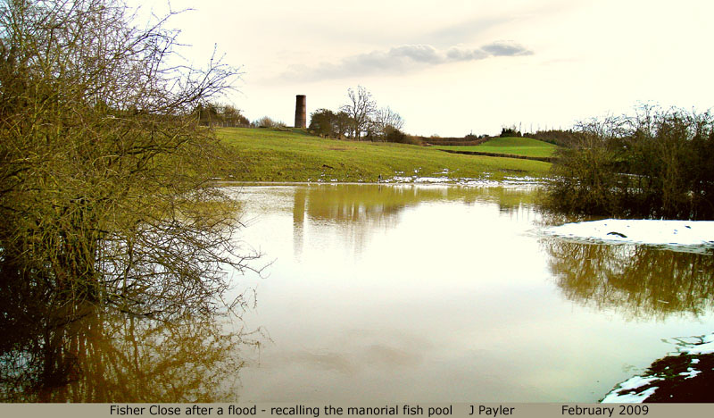
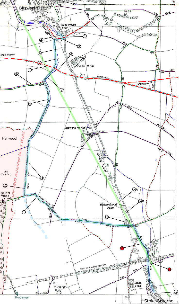
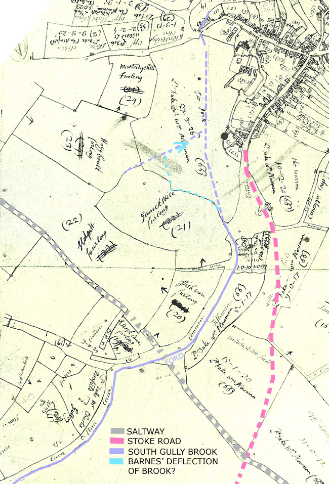
The route is based on paths that link Blisworth with Stoke Bruerne, following as closely as possible the tunnel, starting at the north tunnel mouth and ending at the south tunnel mouth. The numbers to the paragraphs below are links to pointers on the map at the bottom of the page. It is hoped that this route will be more clearly marked using rambler's signs and enhanced with one or two interpretation boards once some funding is in place. The Blisworth Canal Partnership in conjunction with the canal partnership at Stoke Bruerne have plans to raise the funds. Background: Before the advent of the Grand Junction Canal, with its tunnel through Blisworth Hill, there was no cart track or road that directly connected Blisworth with Stoke Bruerne. In the space occupied by the deep excavation for the beginning of the tunnel, at the Blisworth end, there was a village Green along the western edge of which passed a brook that rose on the hill and flowed out under an early bridge for the Blisworth to Towcester road. The brook continued on to a water mill some quarter-mile further north. Through the centre of The Green ran a track that passed close to a much-extended Nun’s Wood and led to Shutlanger. Another track, branching at The Green, led to Roade. These tracks passed through scrub or gorse fields or orderly forest rather than the present day ultra-smooth modern fields. The modern Stoke Road originated as a cart track toll-way created in around 1795 to cope with canal traffic. The toll gate and "gage" for weight was located just south of the Knock Lane junction. As the tunnel was being started, there was much traffic from the northern canal terminal in Blisworth to join the turnpike that led to Cosgrove where the southern canal terminal was briefly located. With the tunnel completed in 1805, the Stoke Road then became the route via which all the boat-horses were led in order to meet up with their corresponding barges after passing through the tunnel. There is no towpath in the tunnel so barges* were "legged" through by walking against the tunnel sides. Now that the Stoke Road carries so much traffic, the over-hill walk, traced as a blue ribbon in the map, between Blisworth and Stoke Bruerne has become the preferred route for ramblers and for what few boat-horse teams remain. The route is based on the 1950s registered paths. 1. This is “The Start”, especially for anyone arriving by car. Driving out of Blisworth, look out for a prominent stone house on the left and turn right just past it where there is a tall black signpost to a car-park and the tunnel. Note that the stone house proclaims “Blisworth Stone Works”, being originally an office building with living quarters established around 1820 and disused by 1920. 2. The steep path is the first leg of the journey from the tunnel mouth. It used to be lined on both sides with a sturdy timber rail that would have prevented boat horses from straying into the wooded slopes, barking the trees and conducting a hopeful search for any narcotic plant species that Blisworth has on occasions been noted for. At the top there was a small stable building – a cold harbour shelter. An old field name across the Stoke Road from this shelter is "Boat Stable Close". 3. The next leg of the journey crosses over the tunnel and leads into a large field. It is interesting to note that this path was once used by a railway for horse drawn wagons carrying limestone down to an off-side wharf on the canal. The red line on the map shows the approximate line of the railway that descended from a quarry behind the stone-works building. The path continues in a straight line. A turn right at the end takes the walker along another path that follows the canal, on its off-side, back to Blisworth. Instead, a turn to the left through the metal gate sets the walker in the general direction of Stoke Bruerne! A left turn in the furthermost field is not permitted! 4. This field is called Fisher Close. There is a broad hump of spoil from digging a shaft immediately to the left after walking a few yards. In 1976 the shaft suddenly swallowed the electric service pole thus demonstrating that Blisworth has its mysteries; the shaft is many yards to the west of the tunnel. Before the field became known as a “close”, its extent was dominated by a “fish weir” ie. a manorial fish-pool. The field was considerably more hollowed out than it appears now and the walker can see the low level that once applied, where a stream runs into a culvert that is boxed in by a fence. This view of the stream can be seen just before the path runs between the field fence on the right and some dense thorn bushes. See this 1727 map for a suggestion on the original course of the stream (then known as the "Gully"). In February 2009, the culvert became blocked with the resulting photo-opportunity recorded above. To the left of that stream there was raised an earthen causeway extending diagonally across the field and the line of the causeway can just be discerned. By the time of the canal, the field had been drained and had been tenanted by farmers for at least 60 years. The causeway across the "hollow" was created in 1800 and was in use for 5 years until the tunnel was finished. The causeway carried Northamptonshire’s first railway that was built using one yard long cast-iron “plates” pegged onto stone sleeper blocks. In fact there were twin railway lines to cope with meeting traffic involved in running the Grand Junction Canal between the terminal in Blisworth (near a large mill building) and a terminal just beyond Stoke Bruerne. The tunnel had taken far longer to complete than expected and engineers decided that the toll-way and a section that passed through the village, could not support the traffic - it was probably disintegrating into deep ruts. Consequently an over-hill railway was constructed by an outside contractor; Benjamin Outram from Derbyshire. Modern railway experts prefer to call the railway a “plateway”. Wagon wheels were retained on flat iron bearers, ie. “plates”, by high flanges cast with the plates whereas modern construction invariably employs flanges on the wheels. The wagons were pulled over the hill by teams of horses. The event that has made the earthen causeway harder to discern was that, in 1982-3, the left hand part of “fish weir hollow” was filled-in with bricks and rubbish extracted during the 1982 – 1984 major tunnel repairs. That “filling” has now sunk down a little. On this walk there will be no other visible sign of the over-hill railway, which follows fairly closely the Stoke Road, until very near Stoke Bruerne. 5. On emerging from behind the bushes, the stream can be seen flowing towards the culvert. The waters reappear near the tunnel mouth as they descend a sloped waterway known as “The Slit”. This was the stream that filled the fish-pool. In the 1600s, it was called Young’s Pool. The stream has carried a few names; in 1700s it was called “South Gutter or Gully”, in 1800s called “Winter Brook”, meaning the miller could use the stream only in winter, and in more recent times Wash Brook and Fisher Brook. The volume of water is very varied and there is no doubt that the engineers building the canal were forced to carefully channel the stream out of their way. 6. The path leads to a gate that has swung on its hinges over a large puddle for the last 30 years, a feature we hope will be remedied. Once through the gate one can perceive a line to the left and hedge extending up to the Stoke Road. In fact this line coincides with Knock Lane (a road branching from the Stoke Road in the direction of Roade) and on 1700s maps the forerunner to Knock Lane ran across the path and is assumed to have once connected up with local pathways to the west running towards Pattishall. There is evidence that the track was once a trading route known as “The Saltway” and was likely established in Roman times. The Saltway is shown by a dashed red line on the map. Local goods moved on the Saltway probably included limestone and timber. The name "knock" for the road comes from atten oke meaning "at the oak-tree". The derivation extends to notch, a sturdy bifurcated oak of cultivated form which, when felled and inverted, yields an "A" for the gable end of an elementary hovel. Thus we are reminded that Blisworth was quite close to being a forest-village in the dark ages and Norman period. 7. Against the sky near the Stoke Road, can be seen the first ventilation airshaft chimney for the tunnel. There are seven ventilator shafts but trees obscure most of them. The tunnel was built originally with only one or two but soon after a fatal accident due to smoke inhalation after a collision in 1861 the canal company opened some of the original work shafts to improve matters. The unforeseen was that, with the start of the use of steam, leggers and steam driven boats pulling a freight barge (butty) sometimes on a long rope would have to meet in the tunnel. See David Blagrove, "Two Centuries of Service". 8. The field to the west is set much higher than the path. There are two points about this. Any truly ancient pathway will tend to be sunken compared to its surroundings. In this case however perhaps the need for the engineers to dispose of many hundreds of tons of spoil from the Green, to create the tunnel mouth, has resulted in this field acquiring extra height.
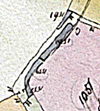
This stretch of
path runs adjacent to Fisher Brook. In a circa 1800 - 1835* estate map there are shown numbered enclosures
(#1558 to 1560) that each included access to the stream - see inset
above. These
were almost certainly rented out by the Duke of Grafton for horse-owners
who were probably attracted there to provide the horses for the over-hill railway. 9A. A path branches to the west following back to the source of a minor stream having no known name. It also follows the Blisworth – Tiffield parish boundary. 10. Following the Blisworth – Tiffield parish boundary the path continues to run beside Fisher Brook. Moving further up, the scene opens out; there is no longer a hedge merged with the stream which now takes the form of a much shallower groove lined with reeds. A naturalist is welcome to explain for us the abrupt contrast. Beyond the group of poplar trees the stream crosses under the path (where, 100 years ago, there used to be a ford) and then forks and collects water from old field drains. Fields on both sides of the path drain into the stream all the way from the local high point at Nun's Wood, on the horizon ahead. The first field on the right marks the beginning of neighbouring Easton Neston parish and was called Henwood, implying that it was a wood owned by the household (hewan) of a religious community - probably the Cistercian Priory. The second field is unnamed but it was occupied by an extended Nun's Wood before about 1750. Note pink area in the map - an extended Nun's Wood indicated in the same Grafton estate map dated 1800 - 1835. 11. The path is now following the Blisworth – Easton Neston parish boundary until, straight ahead, it reaches the next field. An early 18th century document refers to "Sow Gutter Spring" but it is hard to decide where that particular spring was located. As the map seems to suggest in showing a tiny pond, it was probably in the recently cultivated grassland field to the left, but which now appears well-drained. In a 1953 RAF aerial survey photograph the field appears to have "ridge and furrow" patterning that indicates a feudal open field - "South Field". 12. There are two definite sites of Roman Villas in Blisworth parish and one in Easton Neston parish, so far discovered. This latter was evidently an assemblage of buildings including a villa near the centre of the large field to the right and was discovered and extensively analysed by field walking and aerial survey in 1970 - 80. Survey work was continued by the Towcester History Society in 2009. There now seems to be nothing left to see although probably there were once a cultivated garden and a spring. Whether the villa used to be situated in a clearing in Nun's wood or predated the wood altogether cannot be determined. Continue up the gentle slope to the gap in the hedge around the next field. 13. Having gained the next field, the path to the west runs through the edge of Nun’s Wood, which in early May can be a spectacular bluebell wood. There is a path that runs along the outside of the wood towards the south, keeping to the left of a continuing narrow wood, which will bring the walker onto the Showsley Road which, to the left, leads into Shutlanger, a neighbouring village to Stoke Bruerne. Shutlanger is charming in its quietness and it offers a path (Water Lane) extending south to the village of Alderton across a flood plain of the River Tove. In fact you will be able to see the broad valley and the gentle bank to the south on which Alderton lies nearly three miles away. Imagine that in the 1870s through 1900s some men, desperate for work, walked in all weathers from as far as Alderton to the ironstone open-mining in fields around Blisworth and Gayton. In the map, the dotted line shows the line taken by Nunn Lane, as indicated in a 1946 RAF aerial photograph, which it seems continued around a low lying basin (or spring) and descended into the centre of Shutlanger opposite the point that Water Lane begins towards Alderton. The subject is dealt with in a separate short article - Nunn Lane is part of a trackway extending from the turn at Townsend in Blisworth running more or less due south to Alderton and perhaps beyond (eg. Pottersbury and the Watling Street). As this path enters the field mentioned in the previous paragraph it crosses the watershed between the rivers Nene and Tove. The name Shutlanger derives from Anglo-Saxon Shittle (arrow shaft) Hangra (small wood on a slope). We can identify the slope but no particular wood - nevertheless we can picture Blisworth's band of bowmen yomping up Nunn Lane to replenish their quivers just before one of Hereward the Wake's sorties. The shortest path to Stoke Bruerne is towards the east at this point. This corresponds to continuing to follow the Midshires Way for that is the modern designation also of Nunn Lane. The route involves skirting the edge of the field, turning left and following field boundaries until the Stoke Road is regained. The section is often very muddy. Note there is marked on the map a field pond across the path which is a sure indication of the path's antiquity, being a segment of a route probably from Pattishall to Salcey (Note: "Midshires" is an imaginary figment from the 1980s). 14. Just before reaching the Stoke Road there is a large mound to the left. It is a spoil heap from the tunnel excavation and is fenced off for safety reasons. 14A. Standing quite near to the spoil mound one can usually see over the hedge to the left. There is a small farm-house (Buttermilk Hall, the gamekeeper’s lodge in the 1700s) and beyond it is another large spoil mound surmounted by a tall ventilator shaft chimney that is part obscured by trees. 14B. Nearer to the path, appearing to be “in front of” the house, can be seen from the same vantage point a very short ventilator chimney that was pressed into service in the 1860s to enhance ventilation despite the fact it is 12 metres off the line of the tunnel. A side-running shaft was provided to make the connection and any spoil was removed. The brickwork above ground level was rebuilt in 1982, using the classic blue bricks, as part of the tunnel repairs. The shaft is located directly over the line for the tunnel that was thought, by some, to be abandoned as the engineers strove to avoid problems of collapse and inundation. This line is shown as a green ribbon in the map. 15.
Barely 100 yards of walking along the Stoke Road is required to
reach this path that is known in Stoke Bruerne parish as the “Horse
Road”. In the field to the right stands an even larger spoil mound.
The horse-road is where the walker can truly follow the line of
the hill railway as it descended at a regular gradient all the way down
to the canal side in Stoke Bruerne cutting, which is journey’s end.
A short distance down this horse-road, on the right, just beyond
the farmer’s fence, a small wire enclosure can be seen.
It is regarded as unsafe ground where there was once a shaft.
The canal manager and engineer, Thomas
Millner (1859 - 1943), discovered this
shaft in 1922 and fortunately gave its precise position. As it is 61 metres off the line of the tunnel he was unable
to explain its existence but it is exactly over the aborted tunnel line,
so its purpose now seems obvious. 16. Just beyond the dismantled railway bridge (a branch of the SMJ network, Towcester to Roade, Olney etc.) and to the left is much the same sort of feature as described in 15. There is a sunken area in the bushes, lined with moss, which is thought to be another shaft to the aborted tunnel line. This area is not fenced off and anyway lies on private land. For the sake of caution it ought to be said that the rambling thickets and woods near the horse-road are all private land and may carry risk of sudden subsidence or collapse as has happened a few times in Blisworth parish (see 4). This is a concern because abandoned headings, shafts and any miscellaneous earthworks to control water would probably not be brick-lined and therefore very liable to collapse. 17. Journey’s end – where boat-horses can reunite with their barges. A blacksmith, Bob Nightingale, who used to operate at JBJ Park, Blisworth now has his workshop here in a little canal-side hut, within yards of the tunnel mouth. *By the way, the term “narrow boat” is sometimes insisted upon, instead of "barge". However, Thomas Millner referred to the boats as barges, and the people as bargees, as did some old timers in the 1970s who have told their stories of working on the canal around 1900. The term “barge” must be regarded as the traditional name. This is a walk that pursues history so perhaps we should preserve it. Enjoy the walk! Tony Marsh March 2010 Download the map
below; PDF file named walk.pdf to print on A4 - Click
Here |