BLISWORTH
Sewage Schemes and Water
Supplies, 1890 - 1960
Sewage Schemes
The story of the troubles experienced by
the village from their sewage system is one of striving to keep up with the
rapid expansion of the population and laying on an improved service as befits the
20th Century.
The oldest reference to sewage in
Blisworth is a scrap of paper, held at the NRO, on which two sets of notes describe tenders by Mr
Ratledge and Mr Sturgess for repairing piping and cesspits distributed around
the village. The date was 1890. Both refer to about 1100 yards of piping (various diameters)
and either 12 or 14 cesspits. It is not clear whether the pipes were new or
replacements were being quoted for. Costs quoted were around £100.
Another item held in the 35P/C section includes maps of the sewer pipes from
which the diagram below has been assembled.
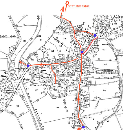 The arrangement was that nearly all houses
either had their own privy, or a share of one, the bucket within which was periodically emptied
either onto the gardens, into a nearby cesspit or into one's 'dedicated' drain
extension if the house or yard was lucky enough to have one. Cesspits are
marked as blue dots and it is amusing to observe that two of them were located
very near to a public house. Drain extensions would have had an iron lid to
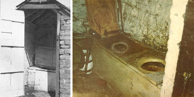
keep smells down. Incidently, if this website stands a
good chance of surviving 50 years, there will be nobody to define 'privy'.
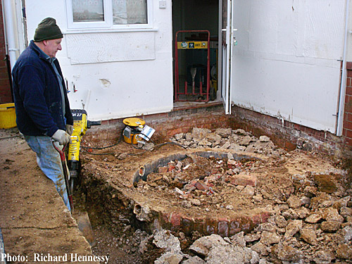
The attached pictures are therefore provided to place
on record the grim, cold and roughly-shod sheds, set at some distance from the
house, which served as toilets in times before 1940-50 in Blisworth. They
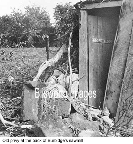
were sometimes referred to as 'offices' in around 1900. Sometimes the
privy was adorned with some humour as in the case of the Burbidge
Bros. (Timber Merchants) off the High Street.
The arrangement was that nearly all houses
either had their own privy, or a share of one, the bucket within which was periodically emptied
either onto the gardens, into a nearby cesspit or into one's 'dedicated' drain
extension if the house or yard was lucky enough to have one. Cesspits are
marked as blue dots and it is amusing to observe that two of them were located
very near to a public house. Drain extensions would have had an iron lid to
keep smells down. Incidently, if this website stands a
good chance of surviving 50 years, there will be nobody to define 'privy'.
The attached pictures are therefore provided to place
on record the grim, cold and roughly-shod sheds, set at some distance from the
house, which served as toilets in times before 1940-50 in Blisworth. They
were sometimes referred to as 'offices' in around 1900. Sometimes the
privy was adorned with some humour as in the case of the Burbidge
Bros. (Timber Merchants) off the High Street.
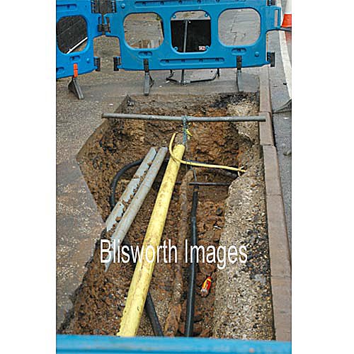
The cesspits and drain extensions would have been periodically
washed down into the pipes. Note that in two locations the sewage
was discharged into the canal, perhaps via a solids trap. In another, the
situation is even worst because it went into the minor stream formed by the
overflow from the canal - see northern edge of the map. In 1890 this
network require repairing and a settling tank was planned before discharge into
the stream. The tank was to be 16 by 20 feet and located low down in the field opposite the Baptist
terrace of houses in Chapel Lane. This settling tank simply overflowed
into the same stream - Wash Brook. Presumably the ultimate aim was to
reconnect the lower High Street pipes in a manner that allowed them to discharge
into the same settling tank. Gayton Road houses used an
"open ditch" which presumably also emptied into the Canal while the
Railway Cottage by the embankment had an "open ditch" going under the
road and joining to Wash Brook. Grafton House and any other property on the
Towcester side of the canal would not
have been able to have a cesspit on the main system because the connecting pipe
could not loop under the canal at West Bridge - they probably used a private
soilpit.
The settling tank to the north of Chapel Lane was about 5 yards
below canal water level. To marry an under-canal pipe to that tank would
have involved a low-level main pipe, following the old stream bed and a considerable length of spurs
connecting up to street level. Such a plan, in terms of a main which served
the village, was probably not put into effect until 1926.
By 1896, when the Parish Council began
their formal meetings, there were 15 cesspits which leads to the conclusion that
many drain extensions were shared and used as cesspits. At the NRO there is a map
of the location of the pits but the archivists report that the document is
rotted and cannot be handled. One can speculate the map was used 'in the
field' and so was not particularly well looked after! Thorough flushing of
all the pipes was called for by the Council in 1896, 1898 and in 1899. The issue was
not mentioned again. In 1898 the
Council considered a 'Night Soil' carting service in view of the pressure on the
system but at 3 shillings per night they dropped the idea. In 1900 and in
1904 the outflow from the tank into Wash Brook was obviously taking solids with
it. On both occasions Wash Brook had become choked between the village and the
embankment and was demanding attention. The man in charge of emptying the tank was sacked for neglect on one
occasion. In 1903 it was resolved by the District Surveyor that any
discharge from a WC into the canal must cease. This meant that much of the
early sewers would need modifying. In 1909 Wash Brook became choked on
the other side of the embankment for the first time.
In June1922 there was tabled a new sewage
scheme for the village but it was not planned to extend it to the Westley Buildings. It
is doubtful much was done then. In 1922 - 24 there was much concern about
the new Bacon Factory putting a large load onto the sewage system. It
seems unlikely that anything was done immediately with the arrival of the bacon
factory, for in 1925 Milton Malsor officially complained about "the bad
state of the brook". A major rebuild of the system took place in
1926. Up until then the brook passed under the railway through two
parallel culverts which were designed by the railway engineers to cope with the
wide range of flow experienced in the brook. In 1926, one culvert was dedicated to
carrying a large diameter sewer pipe, the one to the right as viewed from the
village side, and the sewage farm was then sited on the other side of the
railway. The phrase 'sewage farm' was evidently coined to cover the better
technology and installations to decompose raw sewage in filtration beds and
settling tanks. We can surmise that a good low level main pipe was
installed in 1926 from the point where there was once direct discharge into the
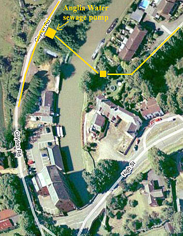
canal behind the Sun Moon and Stars public house. An automatic siphon and
flush pump was placed on the other side of the canal near there so that sewage
from the Gayton Road side could be flushed under the canal and discharged into
the new low-level sewer. This provision allowed a service to the new
houses been built along the Towcester Road. The run-up to this
installation is discussed in a Grand Junction Canal Co.
letter of 1924. The presumed layout of sewers and pumping station and
collection sump are shown in this Google picture.
The collection sump is known (J. Payler) to be there somewhere but no-one has
located it recently! With the improvements, new houses began to be
equipped with water closets connected to the sewers from 1926 but it must be emphasized that a 'water
closet' is simply a pan which can be flushed with a bucket of water from a
nearby well (see below - the water supplies). Older houses continued to use their back garden privies up
until 1937 when some houses could be connected to the sewage system. New
houses such as the new council houses along the Courteenhall Road were given a
connection as they were built.
On the Towcester Road some houses, for
example the Freeston house, last on the left 'going up', was built in 1927,
immediately after the improvements. The houses on the right, going up,
were started around 1930 by a lone builder and with each sale he managed to
finance the start of the next. Alternate houses had wells in their rear
gardens and pairs of neighbours were expected to share these. Probably
every house had a 3' diameter cistern built at the
rear to collect rainwater with a hand-pump in the kitchen for use in the
sink. There is a photograph of the remains of one such cistern at
one of the houses in Towcester Road noted during building revisions circa Feb
2009.
The village continued to enlarge. In
1955 the 29 house council 'estate' was enlarged and acquired over 100 new houses.
Furthermore there was a new development at the south end of the Stoke Road
planned by 1957 (Greenside) and this was apparently a particularly critical one
for the sewage system on account of levels in Stoke Road. Following a
public meeting 11th April 1960, a complete
revision of the system was carried out, particularly for Stoke Road, and gave
the Acme Building Company further opportunity to hastily build on disturbed
ground. The revisions also allowed the development of the
fields between the village and the council houses (Buttmead, Windmill Avenue,
etc) and the field known as Pond
Bank. By 1969 this was all built up and the new sewer system coped well (with
the exception of Little Lane apparently). A few old hands often say that
the installers had got mixed up between storm water and sewage and it seems
likely that such faults are still with us to this day. Storm water is supposed to
discharge into Wash Brook near to Chapel Lane but after a deluge very little
evidence can be seen emerging from the 12" diameter culverts. As a village, we often
see our streets streaming in water because of some limitation in the storm water
drains and no doubt a good deal of storm water is invisible to us because it
runs into the sewers. In about 1980, the sewage
farm on the other side of the embankment was replaced by a pump so that sewage
could by piped all the way down the valley to the Swan Valley area, processed there and
discharged into the River Nene. Wash Brook is consequently a clean stream
now. It is worth just pointing out that before 1800 Wash Brook was the
direct continuation of Fisher Brook which collected water from Blisworth
Hill. In fact "Fisher Brook" is rather a new name for it - the old
name was South Gutter - 'gutter' being an old name for a stream. Once the canal was established, the only water
available for Wash Brook was the canal overflow weir at Candle
Bridge. In the early part of the
20th century, there must have often been conflict between the village and the
Canal Company, for in dry weather Wash Brook would carry very little canal
overflow and perhaps, at times, was only carrying run-off effluent from the
village settling tank. There certainly were a number of complaints from
the villagers of smells etc. and not just from Milton Malsor.
Water Supplies
The story of the water supplies for
Blisworth also shows the stress from enlargement of the village. In the
upper High Street and Stoke Road region, the houses are built on a thick layer
of ironstone and sand which acts as a water conduit. The
annexed picture was taken Oct 2006 outside the Post Office and shows the
ironstone substrate clearly. Beneath this layer
there is blue clay which is the substrate for the lower High Street. As
the clay is more or less impervious to water there is generally a plentiful supply to be had
as a result of digging wells only a few yards deep. Even in the clay it
has evidently proved possible to dig a reliable well, for example behind the
Sun, Moon & Stars Inn, so obviously the clay contains fissures.
 The newly formed Parish Council formed a
Sanitation Committee in 1895. They asked for
a full report on the state of the wells in the village in June 1896 and the
Towcester Rural District Council (TRDC) commissioned a Mr. Salmon to do a
survey. His report, held at the NRO, spoke of wells as either good, poor, need clearing out
or undrinkable. He mentions 31 wells, rather fewer than the 39 indicated on the 1899
Ordnance Survey map, which are highlighted in green on the map here. Note
the scarcity of wells in the lower part of the village. Some properties have to rely on soft water collection
tanks, for example the Westley Buildings (according to Mr. Salmon) though there was a shallow well at the
Drum some 150 yards away but this was one which had been found undrinkable in
1895. A few wells, about 4, were reported as never failing and supplying a
large cluster of houses. One such was the well near the junction of Chapel
Lane with Little Lane. The houses lining the road to Towcester that were
built in the 1930s have a new well shared between each pair of houses.
The newly formed Parish Council formed a
Sanitation Committee in 1895. They asked for
a full report on the state of the wells in the village in June 1896 and the
Towcester Rural District Council (TRDC) commissioned a Mr. Salmon to do a
survey. His report, held at the NRO, spoke of wells as either good, poor, need clearing out
or undrinkable. He mentions 31 wells, rather fewer than the 39 indicated on the 1899
Ordnance Survey map, which are highlighted in green on the map here. Note
the scarcity of wells in the lower part of the village. Some properties have to rely on soft water collection
tanks, for example the Westley Buildings (according to Mr. Salmon) though there was a shallow well at the
Drum some 150 yards away but this was one which had been found undrinkable in
1895. A few wells, about 4, were reported as never failing and supplying a
large cluster of houses. One such was the well near the junction of Chapel
Lane with Little Lane. The houses lining the road to Towcester that were
built in the 1930s have a new well shared between each pair of houses.
 There were political skirmishes in the
1890s as the brewers Phipps wanted the Parish Council to 'adopt' management of wells for the
cottages near the Sun, Moon & Stars. They resisted the suggestion as these properties
were held freehold by Phipps - ie. it was their problem. For the most part,
however, the wells in the village were owned by and maintained by the Duke of
Grafton. He was aging and running low on money before the WWI and it
proved necessary to send deputations to Pottersbury to get some
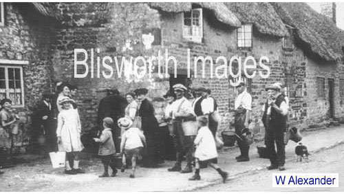
improvement. The chief difficulty year after year was that drought
conditions caused wells to fail and they had to locked up for most of the day.
The picture here shows the queuing that inevitably occurred in the bad draught
year of 1921. Furthermore, it appears that the ironstone mining had
damaged the water supply to the upper High Street area and this point is
returned to, as a footnote, at the end of this article. Yet another
concern was that although a particular well might contain water, the pump was
often broken. By October 1916 and after years of nagging, the Duke of Grafton conceded that all the wells maintenance
should be taken over by the Blisworth Parish Council.
There were political skirmishes in the
1890s as the brewers Phipps wanted the Parish Council to 'adopt' management of wells for the
cottages near the Sun, Moon & Stars. They resisted the suggestion as these properties
were held freehold by Phipps - ie. it was their problem. For the most part,
however, the wells in the village were owned by and maintained by the Duke of
Grafton. He was aging and running low on money before the WWI and it
proved necessary to send deputations to Pottersbury to get some
improvement. The chief difficulty year after year was that drought
conditions caused wells to fail and they had to locked up for most of the day.
The picture here shows the queuing that inevitably occurred in the bad draught
year of 1921. Furthermore, it appears that the ironstone mining had
damaged the water supply to the upper High Street area and this point is
returned to, as a footnote, at the end of this article. Yet another
concern was that although a particular well might contain water, the pump was
often broken. By October 1916 and after years of nagging, the Duke of Grafton conceded that all the wells maintenance
should be taken over by the Blisworth Parish Council.
The Parish Council in 1897 were of the
opinion that water quality and quantity had suffered as a result of the
ironstone mining, particularly at the top of the village. They lobbled for
both more wells or deeper and better headings to the existing wells to enhance
the supply. Nothing was done but there was a bold scheme suggested by an
engineer, a Mr. Roberts, brought in by the
Duke; that the high tank at the mill (Westley's
storage tank is still visible) could be used as a
soft water reservoir which would support a few stand-pipes in the lower
village. Then, working with this reservoir, Westley's steam power could assist collection from a number of
ground pipes which
would need to be laid out on the Towcester side of the village to collect
water. Roberts also came up with a scheme which included a windmill pump, the use of which seems hard to envisage in the
valley near the canal. The committee in December 1897 records "we
cannot see our way to doing what Roberts suggested" and thought little of
the scheme. They still wanted the Duke to improve the wells as a first
priority. One gets the impression that this refusal of the Duke's capital
expenditure actually damaged his willingness to maintain the wells.
Another problem encountered was that the
well outside where the new school would be built displayed the symptoms of
drought after the school was built. Furthermore its contamination by
faecal material ensured it was of no further use unless all water were
boiled. A layer of ironstone had been removed from the field just before
the school was built and this was once presumably a reasonably clean water conduit.
 On the sale of the Grafton Estate in 1919,
the Parish Council took over ownership of the wells thus formalising their responsibility
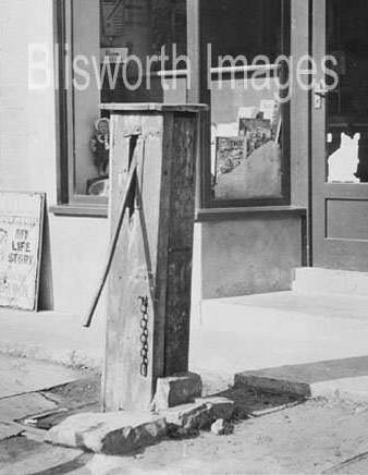
to maintain them. Amusingly, the pump and well located near
Alexander's green grocer shop was inadvertently sold by the Duke along with the cottage it was attached
to. A Mr Pinfold subsequently agreed to sell the well to the Council for a
consideration of £5 and in the George Freeston Collection there is to be found
the Deed of Sale. This was the pump that was carefully preserved, although
hardly potable, in 1950 when the house was demolished in order to build our
present newsagent's shop - see the picture alongside.
On the sale of the Grafton Estate in 1919,
the Parish Council took over ownership of the wells thus formalising their responsibility
to maintain them. Amusingly, the pump and well located near
Alexander's green grocer shop was inadvertently sold by the Duke along with the cottage it was attached
to. A Mr Pinfold subsequently agreed to sell the well to the Council for a
consideration of £5 and in the George Freeston Collection there is to be found
the Deed of Sale. This was the pump that was carefully preserved, although
hardly potable, in 1950 when the house was demolished in order to build our
present newsagent's shop - see the picture alongside.
In the 1930s there were a number of
council houses built. From a point of view of providing water, much
difficulty was experienced in sinking a successful well for the 29 houses needed
to accommodate the families from the Westley Buildings which had been
condemned. No drinkable water was found at all, yet the planners (actually merely some
Council members and one TRDC chief architect) resolved to build the 29 houses along
the Courteenhall Road anyway. Large soft water tanks were provided, each to be shared
between two families. These of course failed and the TRDC was forced to
deliver fresh water once or twice a week - an action that had actually started
in 1932, for a few houses, and continued right up to
the 1950s whilst piped mains water was still not provided for the village.
Northampton town was put onto mains water in 1938. The possible need for
more water deliveries was anticipated in 1936 and there was an uproar in the
village over "the injustice of some houses getting good water, by lorry, the full year
round". The measures were considered by some to be better than using the wells!
 It is said that by 1948 so many new wells
had been dug that the total number was 49 "private" wells and 2 public
(but condemned) wells. It was perhaps in the 40s or 50s that a pump was set up in
a shed
over the tunnel mouth. The pump was to deliver water across two fields to
the back of the planned new council houses where a tank was set up on angle iron
framework (near to the group of garages). Whether this supply was much
help cannot be remembered.
It is said that by 1948 so many new wells
had been dug that the total number was 49 "private" wells and 2 public
(but condemned) wells. It was perhaps in the 40s or 50s that a pump was set up in
a shed
over the tunnel mouth. The pump was to deliver water across two fields to
the back of the planned new council houses where a tank was set up on angle iron
framework (near to the group of garages). Whether this supply was much
help cannot be remembered.
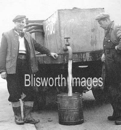
The late part of 1953 saw the installation
of mains water pipes in the village. In January 1954 the pipes were all
washed out and, as no doubt all villagers attentively looked on, the village was
gradually connected up. Ironically, the last houses to be connected
were the 29 houses still being supplied by lorry - they were not served until
1955.
Some householders have proudly kept their
wells whilst others have been closed off with a variety of materials either sound
and precarious. The pump by the newsagent was gone by 1954 and in November
1957 the pump outside the school was removed to leave a manhole cover by the
fence. In November 1964 the old school well was filled in and part of the
cavity used for drainage connections, another manhole cover indicating its
position at the top of the entrance steps.
The large private houses enjoyed the
benefit of a private well. On the Grafton House pages is mentioned the fact that
in c1890 land which included Ramwell Spring was farmed by the Westleys who lived
at Grafton House. A cast iron pipe was run from a tank all the way down the
hill, maybe ¼ mi, to the house thus supplying water at a quite high pressure.
The rectory (built 1841) has a well in an outhouse that is about 20' deep and
carries water to often a depth of 10'. There is a pipe with a leather gland
pump, located about 12' above the water level, driven by an electric motor which
used to pump fresh water up to the first floor of the main house. Before
electricity ~1927 there was probably a small steam engine fired up to do the job
- the layout of the equipment puts one in mind of an ingenious blacksmith. The
present water is a very clear blue coppery sulphate colour - not encouraging.
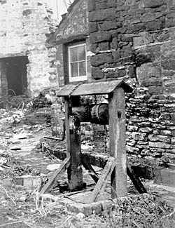 The school well was of the style shown in this picture.
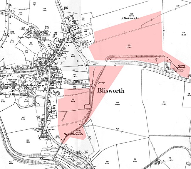
FOOTNOTE: Ironstone Mining
The effectiveness of a well should be partly dependant on water collected
under neighbouring land that has a higher elevation than at the well. For
the upper High Street area, the land on both sides of Courteenhall Road within a
few hundred yards of the Elm Tree would serve as a collection area but this was
all surface mined for ironstone 1870 - 1914. The mining took place on both
sides of the road, see map in the ironstone
section, and the two were linked by a rail line for horse-drawn wagons
which passed under the road a little to the east of the red line in the map above. That tunnel
for the rail would be a local low point and water from much of the mined area would collect
near there. In
1895 the Parish Council, while concerned about the shortage of water for the
village, stated that water associated with the mining area was
'inadequate' yet in 1899 a rather desperate idea was discussed to use the water
from precisely the place mentioned above. Upon reading that in the
minutes, the idea which sprang to mind was that of an open pool - with
the obvious concerns. The proposal was not taken up. Recently a
villager recalls being asked, by George Freeston, to dig near the red dot in the
map above to locate a 2½ foot brick culvert which was assumed to be a drain for
water from the tunnel under the road. The water was thought to run all the way down the slope of Courteenhall Road,
under a private garden (where the culvert had been accidentally detected and
breached during building works) and into the
stream then serving as the village top-water carry off ( including the water
issuing from the sewage settling tanks.) The culvert was supposed to
emerge from under the field a little lower down than the red mark, for George
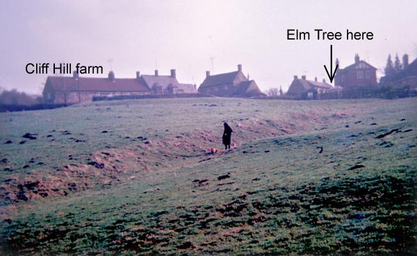
had taken the attached photograph of a deep gully that had been etched into the
profile of the field. A 1970s farmer of the field thought there was a
spring there but that would not explain the gully in the photograph. The most likely
interpretation is that in around 1880 a culvert was built to lead the water away from the
mining area and into the field, so bypassing to some extent the wells in the High
Street. Decades of run off from the mining would have cut the gully. So it
is the end of the buried culvert that behaves like a spring?
Tony Marsh October 2006