|
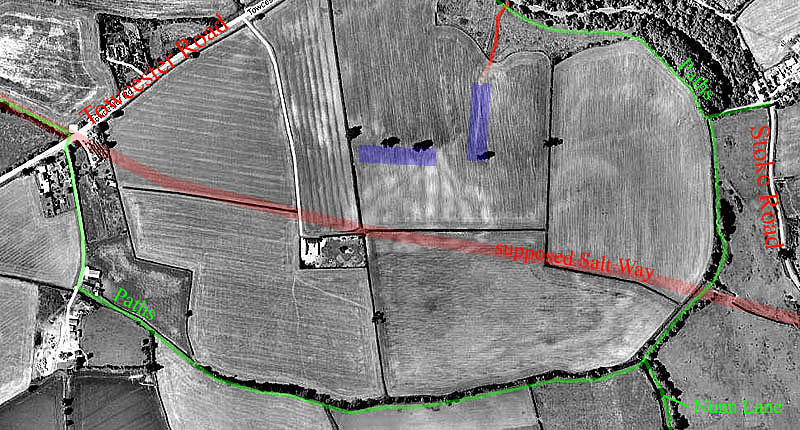
Another Roman Site near Blisworth ? In 1840 a farmer unearthed some blocks of masonry on the Blisworth and Gayton parish boundary, a 100 yards north-east of the "Gayton Road Crossroads". What was subsequently discovered was a Roman villa or temple with modest rather than exotic appointments as judged by details of the remnants. The villa was placed very near the highest point of Gayton Hill. A curious point is that there may have been a straight-line track from the site of our parish church to that highest point. Such track could have been Roman or Anglo-Saxon. In 1991 a Roman crop dryer was found when the new A43 bypass was created. These points amounted to something of a Roman presence at Blisworth - that is, a quarter of a mile away on the parish boundary. Another probably site, that was never investigated, can be presumed at the Loundes where, in c1955, Mrs. Millar found some Samian ware pottery. Now we have a site that is much closer to the village - but lets not get too excited, the purpose of this page is to simply record the facts. Recently archaeologist Stephen Young, who organised the recent investigations in Gayton and Tiffield parishes, has made a brief on-foot survey of a site near to what was once Glebe Farm, long suspected of being of interest. The "Google"-based map below shows the area south of the Towcester Road and the public footpaths marked in green. These paths are mentioned at the outset as a way of pointing out that the central region of the map has no right of access. The area is traversed by the Salt Way, thought to exist in Roman times, which is supposed to link the old Pattishall Road that emerged from fields opposite the Pynus Cottages and track remnants, recorded on a 1727 Grafton map, which made up a westerly extension of Knock Lane, crossing Nunn Lane. Incidentally the area also features two very old quarries which are easily visible in terms of both soil colouration and cropmarks; a faint oval one to the east and a fan-shaped one in the centre. An old field which spanned the area was named "Slatpitt Furlong", meaning an open pit for limestone slates used more recently in ridge-and-furrow cultivation in which the unit of land was termed the Furlong. Because of the established field name in 1727, we can assume that the quarries dated well prior to 1700. Anyway, the layout of the "fan" seems a wasteful approach compared to the 19th century manner of progressing laterally with a single gullet. The fan-shaped one appeared with striking clarity when Richard Hennessy sailed over in 2003 in an air-balloon, the aerial view he photographed is shown on this site. The unofficial finds relating to all this have been added to the Parish-wide mapped record of Roman finds. |
|
|
The on-foot
investigation, July 2009, was carried out in the strip of land shown by
the east-west blue mark. There was found about 20 pieces of Roman
pottery, grey- and grog-ware indicating a long span of occupancy.
The quantity was greater than could be explained from manure spreading
(broken pots end up mixed with barn cleanings hence incorporated into a
spread for fields) and therefore implies a settlement - probably a
farmstead. There were no tessellation pieces which might have suggested
a luxury accommodation. In moving south from that strip, some 20
to 30 yards wide, it was
noted there was nothing more was to be found and the conclusion is that the
quarrying had destroyed traces if there were any. The site
therefore lacks potential and is likely to have insufficient appeal for
any geophysics survey which carries with it a significant cost.
What a shame that is! The significance of the discovery is that a
probable farm-stead has been found so close to the village. That
the little valley occupied by the stream, just to the north and
north-east of this place, could have been settled too seems inescapable
- there was probably a Roman- Blisworth! The best place to look
for evidence would be the bluff on which the church, the rectory and
Blisworth House are placed. Perhaps that area should be designated
of archeological interest, creating an alert whenever new housing or
barn demolition is anticipated. Anywhere nearer to the line of the
stream must have been already disturbed by the canal construction.
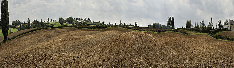
The Fan-Shaped Quarry Area A panoramic photograph taken, looking south,
from the apex of the fan quarry is shown below. The panorama is
nearly 180º wide but, in the picture here, the span has been compressed laterally by factor x4 to accentuate
the field undulations that are present across the area. Tony Marsh September 2009 |
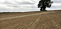 Another brief survey was done in the
north-south strip - not by the archaeologist. The reason for
selecting the strip was the prominent soil colour difference in a narrow
path extending north from a place alongside the "apex" of the
fan-shaped quarry. The "path" is shown in the inset
picture - it is very stony and relatively loamy compared to the sand or
ironstone appearance of the field on either side of it. A couple of Roman pottery bits
were found but the area was mainly strewn with post-medieval (17th to
19th century) pottery and glass and some bits of old brick and farmer's
drains. At the top of the area, an aerial survey photograph from
1951 shows a small farm barn. The impression gained was that the
"path" was once the access route to the quarry combined with a groove in
the ground that was once eroded by a spring and by winter-water from the bed of the
quarry. The spring continues into the field below, being The Park
Slopes, and flows throughout the year, following the red line in the map
above. It is named in c1820 as "Ramwell". The line
of the spring could well have been an afternoon "resort" for
villagers to enjoy the view.
Another brief survey was done in the
north-south strip - not by the archaeologist. The reason for
selecting the strip was the prominent soil colour difference in a narrow
path extending north from a place alongside the "apex" of the
fan-shaped quarry. The "path" is shown in the inset
picture - it is very stony and relatively loamy compared to the sand or
ironstone appearance of the field on either side of it. A couple of Roman pottery bits
were found but the area was mainly strewn with post-medieval (17th to
19th century) pottery and glass and some bits of old brick and farmer's
drains. At the top of the area, an aerial survey photograph from
1951 shows a small farm barn. The impression gained was that the
"path" was once the access route to the quarry combined with a groove in
the ground that was once eroded by a spring and by winter-water from the bed of the
quarry. The spring continues into the field below, being The Park
Slopes, and flows throughout the year, following the red line in the map
above. It is named in c1820 as "Ramwell". The line
of the spring could well have been an afternoon "resort" for
villagers to enjoy the view.