|
|
|
After using any one of the "Go to
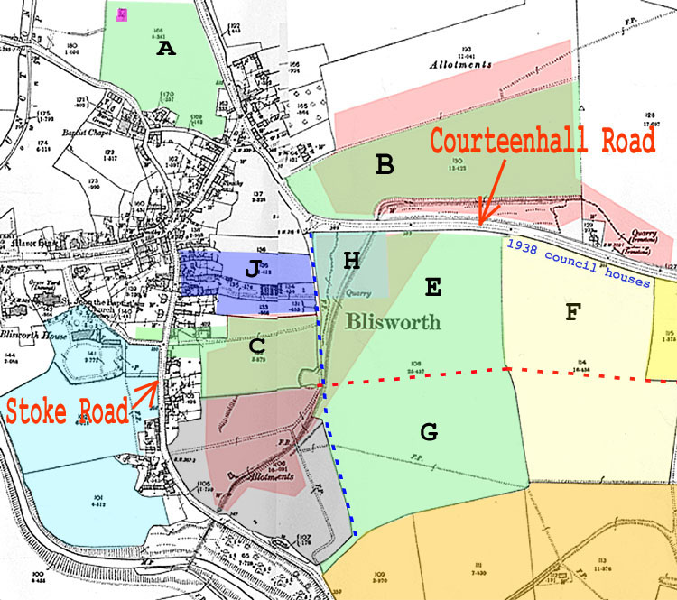
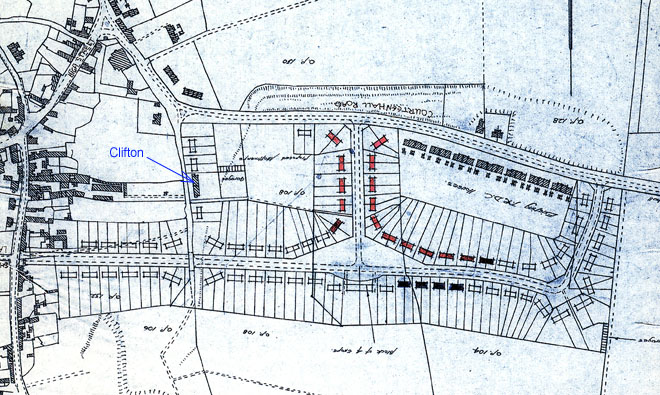
the Map" links on this page, the use Introduction An attempt is made here to give an account of some aspects of housing development in Blisworth, starting with the immediate pre-war (WWII) era. An important issue in the early part of the century was the government’s push towards better health and they introduced the 1924 and 1930 Ministry of Housing Acts. These acts were aimed to improve conditions in housing, especially the more modest housing. Electricity was brought in to the village on overhead wires in 1927 but there are records which indicate some householders paid to have the installation, for example five lights and two power points, as late as in 1937. Many houses in the older parts still have the same overhead connections. Gas distribution by mains pipes in the roadside was installed in 1934-5 and the street lighting was upgraded from paraffin oil to gas shortly afterwards. There was no mains water but there were wells, some were good some of the time, and there was reliance on earth privies except in a very small number of the biggest houses. The housing density in some parts of the village was exacerbating the health problems posed by the privies. The Acts scheduled five year plans where local government would secure loans on easy terms to build new houses, if necessary, and by the 1940’s a total of 44 council houses had been built in Blisworth. Houses were judged based on feasibility for providing adequate toilets. Given that a sewer could be brought to a toilet inside the house, then would it allow fit usage of the remaining space? For the cramped 'one up one down' houses common in the village there was no way a toilet could be walled off and leave adequate space. If these modest houses were packed close to each other it was impossible to even build the toilet onto the outside and this problem applied to many dwellings, especially in Chapel Lane and Little Lane. In tenements such as the one built by the Westleys nearly one hundred years before, on the Stoke Road, there were acute problems in planning sewer connections. Against the criteria, which none of us would object to now, the houses were condemned and the fact that some of the eleven in Chapel Lane and Little Lane were built in the 16th century was not made an issue. Some houses would escape the judgment if a group of two or three in a terrace could be converted into one large house and local government was quite strict with owners who thought they might later subdivide and re-create separate dwellings after some dust had settled. A few say that the destruction of the oldest houses was unforgivable. New council houses were built in three groups just before WWII; there was Greenaway Terrace on Courteenhall Road in 1933, near the corner, and Coronation Cottages in Chapel Lane in 1937. The first of these was built on empty land enabling some condemned houses in Chapel Lane to be cleared and so providing a site for Coronation Cottages. The 25 housing units in the Stoke Road tenement called the “New Buildings” combined with a few other condemned houses called for a significant piece of land, 4 or 5 acres, and in the early 1930’s the Towcester Rural District Council began looking for a site for the third group. In fact, they struck problems - it took them nearly the whole five years allowed under the 1930 Housing Act to decide the site and another 3 years to make the purchase and build the 29 houses. The site they found was established in 1938 (see map above) in which houses were built facing onto Courteenhall Road but some distance from the village centre and called Courteenhall Way. "Some distance from the village centre" - but why? Whatever the reason, the action of placing a significant number of council houses so far away from the village centre caused not only a geographical split but also a social one. It is well remembered by many residents. No doubt, the social 'engineers' in the postwar rural council planning department would have noticed this and made efforts to bridge the rift. The only way was to build houses in the space between and, with its good communications and its geographical split, Blisworth was very likely to be tagged for expansion in the County as the M1 brought businesses out of London. Before explaining what happened it is best to define the features presented in the map above and re-start the account in medieval times. History The basis of the map is the Ordnance Survey 1899. The prominent pathway running north-south from the corner of the Courteenhall Road until emerging outside the village onto the Stoke Road was called the "Back Way" (blue dashed line). It was the edge path for access to the village common land in medieval times. The common land extended south from the Courteenhall Road and east as far as Roade. In fact the basis of the common land was that it was to be shared with Roade people. Much of it was wooded and available for cropping for fire wood and fencing wood. Sales of heavier timber, through the agent of the landlord, were held every year in Sale Wood, an area placed more or less centrally. The common and the three large village fields (being the medieval system) were progressively inclosed by the landlord and by 1718 we learn that a 'small portion was inclosed'. This was the time of the Duke of Grafton (Lord Euston) who held most of the properties in the village. By 1815, when an overarching 'Award Map' was published, the entire parish had been inclosed and large tracts of land were assigned to favoured farmers (usually those with deep pockets able to afford the capital investment) to produce mainly sheep meat and feed for local markets. The output was much higher per acre of land and so the Duke could justify much higher rents levied on the tenants, per acre - being the essential point of the inclosure process. Smaller tracts were set for more small-scale farmers; there was one at the west end of the village and one (called Home Farm in the 20th century) with its farmhouse in Stoke Road. The map shows in green the extent of Home Farm as tenanted by the Carter family in circa 1880 and the Asplin family after that - it amounted to about 50 acres. (There were some other fields, off this map, but they do not concern us) This area is highlighted in deed documents for a property in Windmill Avenue from which much information was obtained. In the map, any area that is underlying in pink was subject to ironstone mining granted by the Duke in 1859 to a succession of firms descending to our present steel company Corus. The railway shown on the map became disused as the iron ore became depleted in c. 1912. For other economic reasons, there was no mining after the WWI and land was left in an uneven state. Another grant by the Duke, at some time before 1838, was the setting up of dozens of villager allotments on the area coloured grey; an area that was formerly the Manor warren or Coneygreen. It appears that a later Duke was seduced by the promise of wealth from the iron at the expense to both farmers and allotmenters. The northern part of the map shows a council designated allotment area based on 'parish or church lands' which became the property of the County Council. It too was affected by the ironstone mining. Throughout, the mining was open cast and anything from one metre to three of over-burden was required to be temporarily removed as the loose seam of iron-bearing limestone below was extracted. The over-burden was shovelled back and it is doubtful that topsoil was preserved. There was only a narrow band of mining activity at any one time and the iron company had only to pay dues for that area to the proper tenant of the land. Thus villagers and farmers were 'shafted' by the miners and then left with poor land. In 1919 substantial death duties were incurred by the Grafton Estate and the new Duke was forced to sell a majority of his holding which included his entire holding in the parish of Blisworth. Tenants of lands and properties were given a first refusal to purchase. Asplin was fortunate in being able to buy his small farm and continue. In April 1924 he sold a square of land to the company running the bacon factory (C. W. King and Company Ltd). This square is coloured turquoise in the map, labelled J, and was used to house the families of two key employees at the bacon factory - the cottages were called Clifton Cottages. Asplin had probably sold also the area of the remaining mining trench adjacent to the Courteenhall Road and he might have sold some modest patches for the construction, in the early 1930s, of the two blocks of council houses near the corner of the Courteenhall Road which were to house families displaced from Little Lane and Chapel Lane. Incidentally, the purple square on the most northerly field in his holding was the sewage setting tanks which were set up perhaps as early as 1870 and never really worked well. In the 1930s the remaining coloured areas were all owned by different people - light blue, by the owner of Blisworth House, dark blue, formerly by the Westley family (sold to them by the Duke, perhaps as early as 1850) and then the Sturgess family and finally British Bacon Company and dark orange, Hereward Wake. The ownership in the 1930s of the areas coloured light and medium yellow are not known for sure. Medium yellow might have been the site of lime kilns as in a 1947 aerial photo (NRO) the area is fenced off with what appears to be lime exposed to the surface just to the south. Incidentally, some 'fissures' in the map arise from an attempt to photograph and electronically join various scraps. The joints are gross in some places but do not detract from the message provided by the map - apologies. A 2006 map from Google is provided for information at the end of this article. 1937 - Location of 29 houses Now we can return to this question. Documentation exists in the N.R.O., deposited by the Towcester Rural District Council (TRDC), which record the minutes of their 1930s housing committee. Scant record is available in the Blisworth parish council minutes. There seems to be an irritating level of abbreviation by the secretaries of such committees; they never seem to explain a 'state of play' or give an explanatory overview but only mention the action in hand, without context. It seems this goes on today too. Anyway, it is plain that the housing committee spent years looking for a suitable plot for these 29 houses and declined to make a compulsory purchase although that would have been within the power of the TRDC. The criteria were not spelt out but it was clear that size of plot, needing to be one plot for the 29 and located in the parish, and the availability of good well water were paramount. Various tests on wells done throughout the village in this era were showing that wells were unreliable. All of the public wells were in dire condition at least at some time in the year. If there were private wells having high reliability no-one told the parish council! Drilling for water in the 1930s was therefore conducted further a field and, even where the depth was taken to 200 feet, only brackish water was found. The situation within the village necessitated the council to deliver water to some council houses before the 29 new houses were built. Faced with this, it would have been sensible to have admitted that Blisworth had no good water and the basis for selection of a new site should therefore have omitted the water criterion. The location chosen is shown in the above map - on the south side of the Courteenhall Road some hundreds of yards away from the village centre. After the WWII it was voiced unofficially by some occupiers of the new houses that there must have been some other agenda. There were plenty of sites available nearer to the centre of the villag. The council could have exercised compulsory purchase powers whilst upholding the reasonable consideration that the small farmer, located in the centre of the village, Mr Asplin, with poor land and only 50 acres, should not be hammered by such a purchase order. Anyway, it was done. As the prospect of war loomed, the local councils were appraised of the possibility of relocated people from London in Blisworth and many other Midlands villages if war broke out. The TRDC therefore urgently requested that the occupants of the condemned buildings in the Stoke Road move into the new houses as soon as possible lest they loose the chance of the accommodation. Water was provided by rainwater tanks for all the new houses, for water that was to be put to general use, but these rapidly fouled and were dry in summer. Water, especially for drinking, had to be delivered by a TRDC lorry into galvanised tanks in front of the houses once or twice a week. Otherwise the water could be obtained in person by walking to the centre of the village to one of the public pumps. The 29 houses were fitted out with some expectation of a mains water supply; there were baths with a working drain. Taps were fitted to them with no water pipe connections. There were WCs in the outhouses but water for flushing them had to be applied from a bucket. At this point it was voiced and recorded in a parish council minute that some occupants would have preferred to stay in the condemned houses in Stoke Road where the water was better! Others in the village with recourse to only the public wells were miffed that the council houses were getting good water by cart yet they paid the same rates. In pre-war times, council houses throughout the land were often described as 'housing for the working-class' (Blisworth Parish Council - no exception) and this class distinction of course added to the geographical one. Readers might be dismayed to see that this mainly historical account includes comments straying into political areas. Let us at least acknowledge that the actions leading to splitting the village, presided over by the parish council, was the 'biggest thing' to have happened to villagers since the sale of the estate in 1919. Joining the village 1950s The farmer at Home Farm, Mr Henry T. Asplin, died in 1952/3 and on the 5th October 1953 Knud Erichsen of Blisworth House bought Home Farm. The Erichsen's had arrived from Denmark in the late 1940s. Erichsen set about pig rearing on the fields of Home Farm being a project in tune with the nearby bacon factory. However, from the deeds of a Windmill Avenue house it is clear that a consortium of four developers very soon purchased some of the Home Farm land. The four were named Dartvale Ltd, Perados Investments Ltd, Hedgevale Ltd and Bridgefell Ltd. It is not clear whether these companies were actually developers or just financial holding entities. Area 'E' was purchased for £17250. Incidentally, Blisworth was finally piped and connected up to mains water in January 1954, some 17 years later than Northampton. It may be helpful to refer to a general modern satellite map of the village, as well, at this point. On the 21st September 1944 the clerk at TRDC wrote to all parish councils requesting that they survey their village and report on future housing needs once the WWII was over. Evidently a further 16 houses were expected to be condemned and 67 returning servicemen were anticipated, mostly requiring a house. In addition 16 girls of the village had got married during hostilities and were living with parents. There is no record of the total indicated to TRDC but it must have been around 80 housing that would be needed as council-houses. In October 1954 the chief architect of the TRDC published a working plan which showed the 29 original houses encircled by another 80 council houses (as expected from the previous paragraph) on area 'F' and neighboured by yet another 30 houses utilising the field adjacent to Back Lane (area 'E') and yet another group of houses that would use all the space between Back Lane and the Stoke Road (area 'C'). The plan incorporated the Clifton Cottages square (area 'H') utilising some of the land for a few garages. It is obvious from the plan that Blisworth would have received another 140 or more council houses if this had been put into action. At least the village would be joined up! The area being considered was not all of the Home Farm fields but just that part north of the dotted red line placed on the map and south of Courteenhall Road. The TRDC must have had second thoughts about this grand scheme because houses were in fact built only on the pale yellow and part of the darker yellow areas (areas 'F') in the late 1950s - Connegar Leys. The amazing thing is that nowhere in the parish minutes is there record of discussions about that thrust for140 houses and its subsequent attenuation. The first minute on the topic is to note how many Blisworth residents could now move into the new houses in Connegar Leys - the name arising via Geo. Freeston from the name of the nearby field (part of area 'G') used for foddering the medieval warren. Notions on the geographical split in the village are forgotten now. Those who grew up in Connegar Leys are proud - see for example the piece written by Andy Newbery.
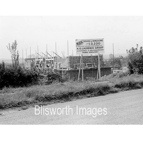
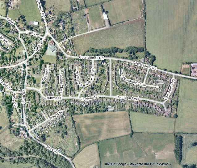
The two parts of Buttmead were not joined in a timely way, where the street crosses Back Lane, and some villagers lobbied for them to never be joined (for motor traffic) so that a rat-run from the Stoke Road to the Courteenhall Road could not develop. With the daily 9am traffic madness outside the school and the rush hour stress on parts of the High Street, the 'rat-run' is of course welcome. Home Farm included an orchard on the opposite side of the Stoke Road, also coloured pale green. It was developed to yield two houses by a third builder (unknown at present). At some date circa 1968 K G Laurence bought outright the lands 'H' and 'J' from the bacon factory company (by then this was Buswell Ltd, who had mercifully been 'deflected' to a Northampton Road site after asking for permission to extend their slaughterhouse off the Stoke Road). Laurence's were then able to finish Wellspring and extend the two Wilson streets towards the school and would, from then on, qualify as developers rather than just builders. They went on to develop the Pond Bank field adjacent to the canal and finally they built six houses on the Stoke Road end of area 'J' where there were once the 'bacon factory cottages', see image 30-03a on this website. Although not really part of the process of joining up the village, the steel company who owned the allotment field (coloured grey) developed the part of the field that had been most severely damaged in terms of soil condition. This occurred in the late 1950s and the builder was called Acme Building Company Ltd. The street created was Greenside which opens onto the Stoke Road. A further detail, which is evident in a current map, see below, is that the TRDC thought that rear gardens for the council houses in Connegar Leys were too large and an additional street of bungalows, some of them with warden surveillance, were built in the middle in the 1970s. The street created is Greenaway Close. There were two side issues, both documented elsewhere on this website, wherein (1) the owner of Crieff House at the time offered his paddock to K G Laurence so that the latter could extend further the streets Home Close and Eastfield towards the north but this was attenuated enough for the school to obtain a green playing field (Mr L Piggott was the Canute!), (2) the parish council received a gift of land from Buswell's who may not have told K G Laurence about it! Some juggling ensued, made more complex by the realisation that the new Village Hall would need a car park. Continuation in the 21st Century The areas 'G' and 'B' remained in Erichsen hands, undeveloped, whilst he presumably disposed of the most northerly area, area 'A', as we now see that field as a self-contained private smallholding. The areas 'G' and 'B' were willed by Erichsen to another family with connections to Blisworth. As is almost always the case with tracts of land adjacent to a village, area 'B' was offered in a bid for a 100 house scheme suggested jointly with the Courteenhall landowners in 1988. Various sweeteners were offered, a new village hall for example, but the village and thankfully the planners at Towcester rejected the whole idea. However, the western half of 'B' has recently succumbed to development for 'affordable housing', being a more socially aware project, and was established as a new street, Ladyfield, in 2007. Pockets of land have been and will continue to be developed within the village limits. It is to be hoped that no major development occurs at Blisworth in future. Unfortunately it is a fact that, as generations pass by, the pressure on the land is only the one way. T. Marsh June 2007 Please see below for a map, courtesy of Google.
|
|
|