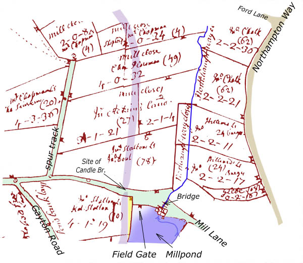
Blisworth Water Mill and Neighbouring Fields
The map above is a composite based primarily on the 1729 mapping of the fields. At that time, any buildings were shown as miniatures of the actual construction. Thus the water mill at the north end of the millpond appears as a house (upside-down) with a single chimney and a emerging stream more-or-less from its centre. The stream passed under a small bridge which provides access from the end of Mill Lane (now Chapel Lane) to the Gayton Road. The configuration of the lanes (green) and the main road (brown - Northampton Way) are immediately recognisable although the spur track off the Gayton Road was ploughed up in the 1960s and the broadened 'common' land near the mill has been aligned as a narrow road going over the "new" canal bridge. The position of the canal (1795) is shown in this map, along with the bridge now known as Candle Bridge.
This is the only 'picture' of the mill house. We read from notes prepared for Bridges, 1718, that the mill had an overshott (sic) wheel and the present lie of the land indicate a fall for the water of around 12 feet. In 1729, when the map was drawn, the millpond was in fact mostly drained and there was left only a small reservoir near the mill - as shown on other maps - so that, in effect, water made its way to the mill by the path indicated by the blue arrow. In the map, there is shown a field gate in the boundary of every field including one for the millpond field (known as Lower Pond Bank Leys.) In one later map, when the mill had become disused, a road is shown sometimes on both sides of the mill building. The two 'roads' can be assumed to lie at two distinct levels, one in the dry and compacted millpond and the other following the bridge.
In preparing this map, a liberty was taken in applying a blue colour over the entire field, except for a corner that one would expect would have been too high to contain water. There is no way of knowing how far back in time one must go to find a full millpond. However, a lease document at the NRO (YZ3559) refers to income from a number of mills in Northamptonshire in a deal between John Sedgewick, Gloscestershire, William Birke of London and Lady Dorothy Savile of London. How any of these three relate to the Graftons is a mystery. The wording suggests that the mill was functional in 1720 in that a reasonable rent was levied - so perhaps the conversion of the rather silted millpond to grassland occurred circa 1727 when the 2nd Duke 'tidied up his accounts' for his estate and had new maps drawn up.
Most of the fields have been created by subdividing the medieval common field known as Nether (north) Field. The subdivision took place in the 'Inclosure of Land' which involved the allocation of fields to specific farmers who were expected by the Duke of Grafton to deliver better productivity than the previous tenants. The boundaries reflect the alignment of the original ridge and furrow cultivation, as used by medieval tenants, running down on each side of the mill stream. A photograph of the field next to the spur track confirms this. The process of inclosure therefore must have begun before 1729. In 1718 it was reported that a small part had been inclosed. It was not completed until 1815 when a new official map was drawn up - the 'Award Map'. Some of the field boundaries still have the same alignment.
Note that a 1/2 acre piece of land near to Mill Lane is labelled as Glebe land. This is almost certainly one of many parcels of land known as Church Land or Town Land which contributed to our community field.
The stream bed still takes the same path in the long straight section but is now fed from an underground culvert which delivers water from a weir at the bank of the canal. Before the formation of a lake in 2004 and the incidence of much earth-moving, the line of the stream from the bridge to the beginning of the straight section could be easily discerned in the profile of the field. The stream is now known as Wash Brook, both in Blisworth and Milton Malsor. In circa 1800 it was known as Winter Brook. However, the main stream which once fed the millpond (but presently empties into the canal) was known as South Gutter. The more recent names of Fisher Brook or Fishweir come from a field further up the valley (Fishweir Close) which was presumably flooded to provide a fishing resource for the Lord of the Manor.
The map suggests an intriguing possibility for why the present canal company (British Waterways) own a narrow strip of land immediately adjacent to the towpath at the back of the even numbered houses in Pond Bank. The location of the canal is ghosted in the position that is derived from superimposing a 1970 OS map. The original purchase of fields for the canal by the Grand Junction Canal Company probably included, for the sake of simplicity, just the lower part of the field marked as Pond Bank Leys. The boundary of that field on its eastern edge 'awards' a useless strip to the canal company. The strip is coloured yellow in the map and has been, at times, a bone of contention over the rents since the housing estate was established. It is a supposition that at the time of the sale of the field for development, British Waterways' legal advisors were wide awake to the implications of some old map and not influenced by the position of a 20th century hedge which had become established very close to the towpath (see pictures of the weir).
Description of the Mill 1720 ... and also all that fee from rent of four pounds reserved and issuing out of and for a mill at Blisworth in the said county [Northampton] called Overshott Mill and also all that ... It was the only mill out of the six which was given a name, allbeit a rather generic one.