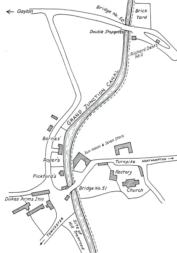
VILLAGE 'WEST-END' MAP
An interesting map has been found in the book "The Military on English Waterways 1798-1844", Compton & Carr-Gomm, drawn by 'RJD'. The book documents the movement of militia on the waterways and details the function of Weedon Barracks. The map is reproduced, presently without permission, in the hope that someone can elucidate on the original source of the mapping. One or two errors have been corrected since the map claims to represent the area in 1809 but some inconsistencies remain, viz: the name of the inn 'Sun, Moon and Seven Stars' should be 'Half Moon Inn' at that time; Richard Dent's Mill is now correctly positioned and should be in a disused state since water was unavailable for milling from about 1795; both the rectory and the Sun, Moon .. Inn are mis-drawn.
The map possibly relates to
an original source of the following information:
1. existence of a small building near and to the south of bridge 50.
2. that the field so outlined nearby was a brickyard. (1938 information
mentions Brick Kiln Field for a much larger area.)
3. that the nearest wharf to bridge 51 was Pickford's or, at least,
originally Pickford's (by 1805 the firm was supposed to have de-camped to Blisworth
Arm since their specialty was trans-shipments to/from the canal - they were
sub-tenants* of Barnes & Roper Co.)
4. that the company Barnes & Roper Co. divided their yards so. (That they ceased to be partners
in about 1804 is documented.)
5. the Pickford's warehouse appears to be drawn consistent with the 1838
map on this website but the 1812 Award map shows the warehouse nearer to the
bridge.
6. that the wharf supervisor's house was so positioned close to the south
end of bridge 51 as early as 1809. It does not appear on the 1812 Award
map. (On RJD's original drawing the house was labelled a 'Legger's
Hut'. But it was not until about 1825 that legging boats through the
tunnel had been adopted.)
* see Blagrove "Two Centuries of Service", pages 20, 23 & 37.