Early 19th Century Canal Maps
| Please use the Search Box on the homepage to get the most out of this website |
USING AN 1811 MAP OF WHARF AND MILL-POND AREA AS A BASIS
There is also a 1729 map of the Mill Area including fields to the north.
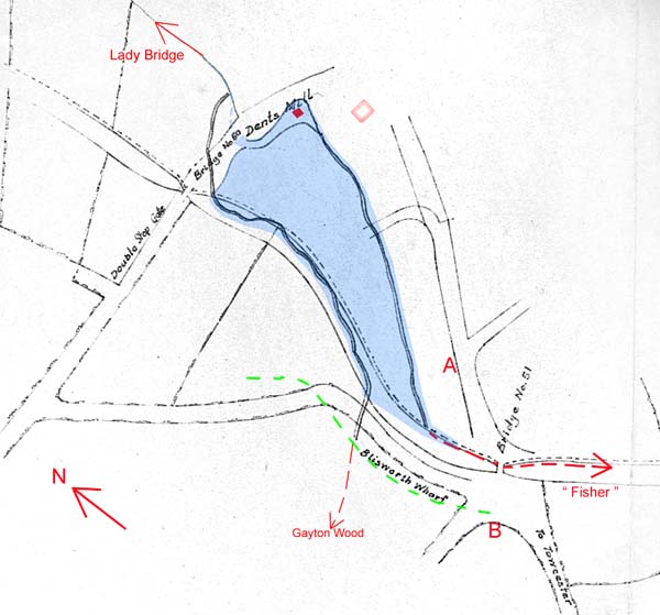
The black and white part of the map below is a copy of a photocopy found in the GF 1996 collection at the NRO. It is evidently concerned with canal and water, labelled No 10, dated 1811 and clearly drawn by or for the Grand Junction Canal Company. The roads appear to be drawn far too wide and with casual precision compared to the line of the canal between bridges no. 50 and 51, which is faithfully mapped. Unfortunately there are no buildings included such as the Half Moon Inn at 'A' or the Dukes Arms Inn at 'B'.
Some comments about the water courses and the
millpond, the position of roads and
finally, miscellany, are made below. If the links in
the preceding sentence are used, it
will be easy to switch to/from the map using the 'back'/'forward' browser
buttons.
Water Courses and
the Mill Pond
The map shows two streams that were there before the construction of the
canal. One from Gayton Wood and one from Fisher Close (or the
Fishweir) to
the south of the village, as they were positioned in 1793. Dent's mill was
enjoying the collection of the water from one stream going into a small reservoir and
such reservoir is evident in the 1729 Grafton Survey
map. As stated elsewhere, Grafton had clearly decided to drain the mill pond prior to 1729 to
provide a meadow. Every civil engineer will know that the effective way to
clear an area of water is to dig a duct on both sides of the area, at the same
level - in this
case, one for each of the two streams. No records exist before 1729 so it is
a matter of speculation when the mill-pond was drained. Perhaps it
was around
1650 when farming methods were improving and the first few inclosures were
made. The layout tends to confirm that the mill pond was once capable of
extending over the whole area shaded blue, it being level (otherwise the cuttings
for a stream on each side would not be effective in draining the area). The area is named Pond Bank
Leys and in all maps there is a distinct boundary aligned with the east stream
which parts the paddocks of properties on the High Street. Both streams
drained into the channel which runs down to Lady Bridge near to Northampton, a
stream now called Wash Brook. After the completion of the canal, the
stream from Gayton Wood would just run into the canal, as it does now. The
water from Fisher was ducted to pour into the canal near to the tunnel portal
and so would no longer supply the miller's reservoir. That stream on the eastern
boundary would
carry a little water only at times of sustained wet weather. Any milling at the mill ceased well before
that however; the miller, Richard Dent, sold the mill to the GJC in
1794, and a garden somewhere nearby, and thereafter concentrated on wind-milling on Cliff Hill as indicated on
the 1815 Award map.
By 1838 when a rather precise map was prepared for the Grafton Survey of that year, the reservoir had been tidied up into the form of a small sump which drained by underground culvert into Wash Brook. That sump is located at the small red square in the above map. It was filled in around 1880 and was not disturbed again until around 1968 when a thorough draining of the area was planned prior to filling it with housing. Old timers in the village at that time warned the builders they would have trouble with that field. Their warnings proved correct - the builders found it was necessary to extend the foundation brickwork of some houses at the northern end to a depth of over ten feet and the western side of the area tends to get water-logged in winter.
As close as can be judged, the location of the overshot water wheel at Dent's mill was at the lowest point of Chapel Lane, on the hedge side of the road. Some maps show the mill centred in an 'island' between roads. This suggests the existence of both a low path and a high path.
Roads
There are two striking differences in road alignment compared to what would
be expected.
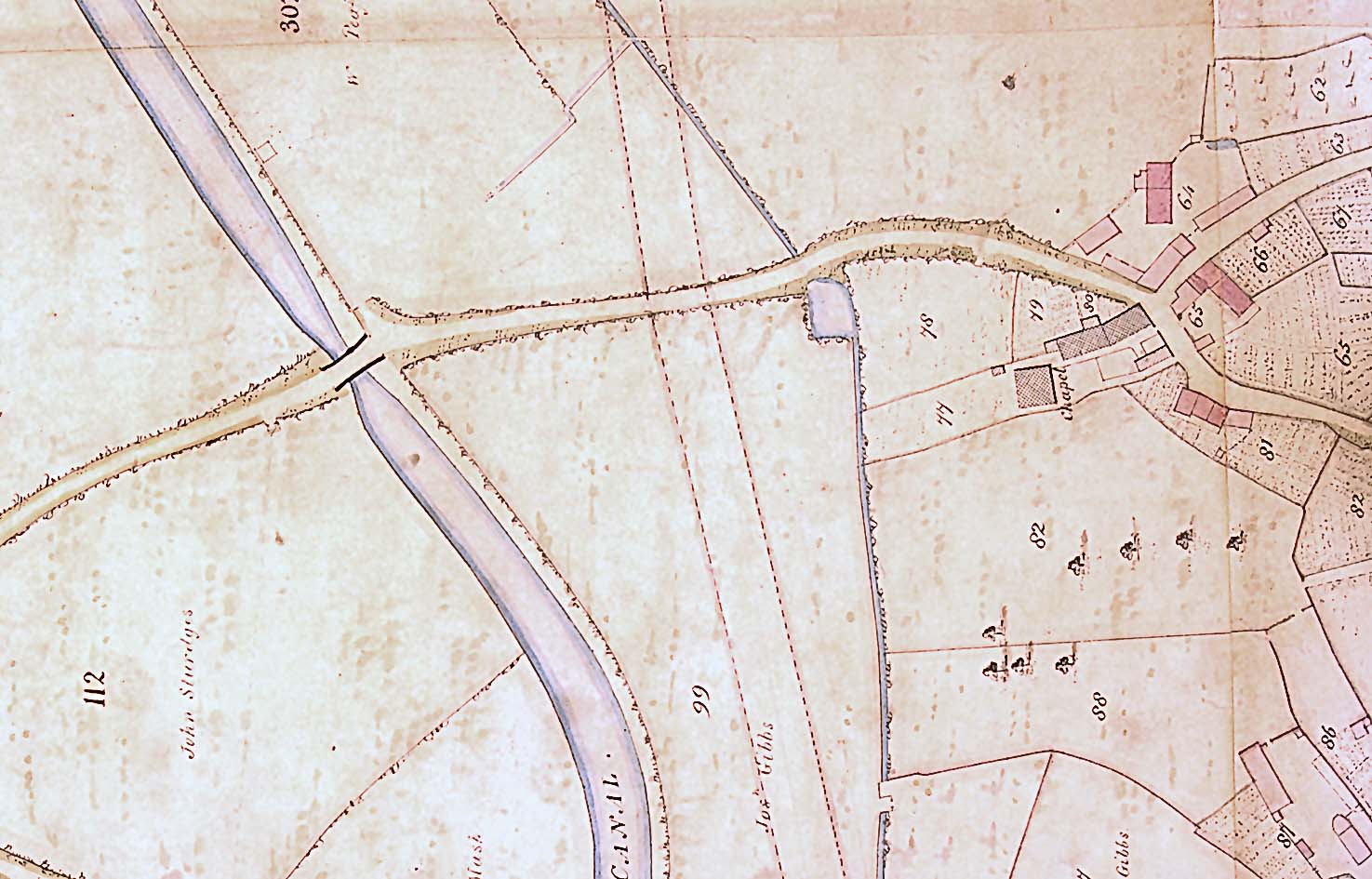
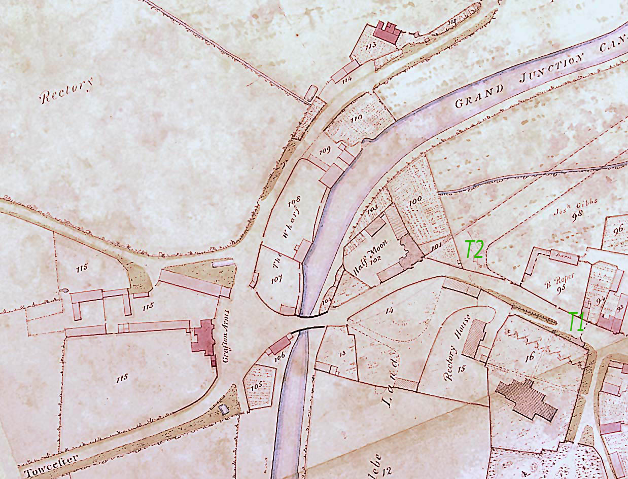
First the position of Gayton Road adjacent to Blisworth Wharf. In this map there appears to be no room for the wharf yards shown on the 1807 map and the 1838 map of this area. Perhaps, briefly, wharf and road were one and the same. If no buildings were required initially that would make sense. Note that the 1807 map is somewhat dubious in that it could be a blend of features, some of them as late as 1838. The 1838 map agrees precisely with the present day ordnance survey maps and the green dotted line indicates the path of the Gayton Road. Both this path, and the one depicted in black above, comfortably 'go around' the old house near the corner now known as "The Bays". It is very tempting to think that the original line of the Gayton Road was quite close to the canal but, before long, the need for more room at the wharfs (perhaps for buildings etc.) required that the road be re-routed. In fact the Award map of 1815 shows the road in its later position.
Second, a part of the Blisworth bypass is shown but it points to a junction with the Northampton road near to Cliff Hill farm. To demonstrate the point, the position of the Baptist Chapel that would be built in 1825 is shown by the hollow red square. Note also the curved spur road in the above map turning off the bypass into the Pond Bank Leys - or indeed, it seems, entirely hijacking the road, from the bridge end, for the access to the field. This was perhaps to provide a better access at that time to the field than provided from Chapel Lane. That the detail was included in a GJC map hints that it was the GJC that required the access to the field. Then there is the alignment of the bypass (which of course was never built) that is suggested in 1838 which was to cross Chapel Lane (or Mill Lane) in the vicinity of the 'en' in the word 'Dents' in the above map and join the Northampton road at the railway arch. Clearly, the idea of a bypass was being considered for many decades.
Finally, it is evident that the map-maker in 1811 was not that bothered about the exact mapping of roads, for the alignment of the High Street at the Half Moon Inn (A) is far too southerly. Dingley Lane running adjacent to the Dukes Arms Inn (B) should be aligned far nearer to parallel with the road to Towcester. These points tend to detract from the authenticity of the map in regard to roads and makes us question the theory regarding the re-alignment of the Gayton Road, discussed above.
Miscellany
The four-sided irregularly shaped fields in the northern corner of the map are
recognisable as a portion of the medieval ridge and furrow-cultivated north
field (Nether field). There is no indication of a brick works near to
bridge 50 (later to be known as Candle Bridge).
A 'Double Stop Gate' is labelled near bridge 50 as it is also in the 1807 map. A stop gate is a wooden gate similar to a lock gate that can be used to dam the canal in the event of a leak or need for repairs, but which is normally kept open. Why it was described as a 'double' is a mystery. There is no remnant of the structure at the present time.
There is no indication on the 1807 or 1838 maps of an overflow weir set to deposit surplus water into Wash Brook. A weir was first placed just north of bridge 50, at a date unknown. It became redundant in 1958 when a larger one was built just south of the bridge and was finally sealed shortly after the September 1992 floods.
---------------------------------------------------