|
The Great Fire of Blisworth - May 28th, 1798
Two newspaper accounts from the times set the scene: Northamptonshire, June
4th. 1798. Northampton Mercury
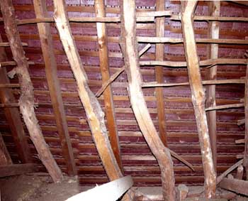
June 9th. 1798 ________________________________________________________________ Comment From the Grafton rent records it appears likely that Joseph Hedge lived at Crieff House - the problem being mainly that Joseph, specifically, is not mentioned. A feature of one or two houses in the village, before they were demolished in the 1930's, was that the thatched roof extended, on one side, down to within a yard or two of the ground. Perhaps it was a building of such a design behind Crieff House which was the first to catch fire. Click here to see a photograph heavily modified by G Freeston showing a building being re-thatched having very low eaves in one place. So far, there is evidence for fire damage along the High Street on the opposite side to the Royal Oak Inn and for a short distance along the Stoke Road. Insurance was not fashionable in those days and measures were doubtless taken by the Rector and officials in neighbouring parishes to produce a fund from public contributions and church money to re-house the unfortunate villagers. The Duke of Grafton probably helped also - he immediately put into action plans to insure the buildings of all his key tenants, ie. the farmers. At the time, 1798, the Grafton Estate was about to be re-organised on the basis of new farm houses with more extensive buildings set up typically a half to one mile outside the village, amidst clusters of associated fields. This might explain why some houses in the High Street were not replaced for over fifty years. Below are maps and accounts of individual houses for which evidence exists. |
||
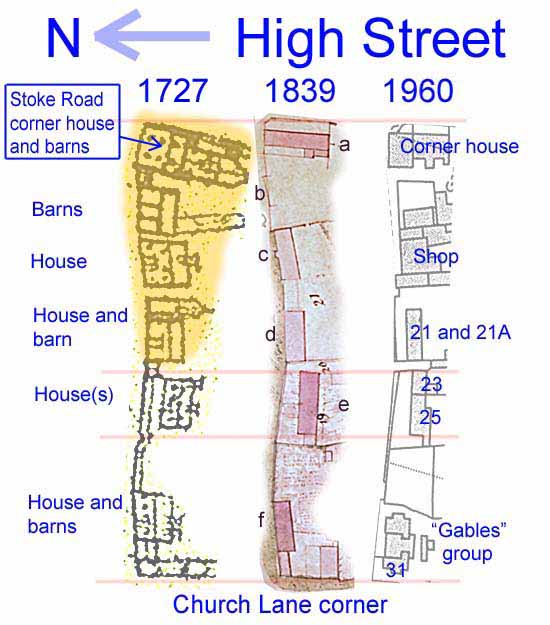 |
This panel shows just one side (the south side) of a section of the High Street, formerly known as Bridge Street, between the Stoke Road corner and Church Lane. The plan is shown at three dates; 1727, 1839 (both Grafton surveys) and 1960. Some pink lines link the three plans at some readily identifiable features. The houses of most interest are labelled in sequence (a) through (f) on the 1839 plan and in the section below an account is given in that sequence. In the 1727 plan is shown, with an orange area, the buildings thought to be damaged by fire. In the 1839 plan the houses coloured darker pink are ones in occupation by tenants while the others are either barns or permanently unoccupied. |
|
|
(a) The birds-eye view of this corner house shows a substantial frontage on the high Street in 1727. By 1839 the house is a relatively narrow gable "end-on" to the High Street and so is likely to be a replacement because of the fire. An examination of the building which is now at that place shows a narrow gable but there are some indications it has been modified at some time later in the 19th century. The building housed a shop at the corner from approximately 1880 and it incorporated the village post office. This was the second location of the post office on the High Street (see image 32-04). (b) Nothing is said of this place in the survey document of 1839 but it appears that the draughtsman has recorded the existence of a building platform abutting the street. Interestingly, the gap left after the fire remains unfilled today. (c) The 1839 survey states that this place was "in ruins". In 1866 the plot was sold to the Northampton Progressionists Society (a forerunner of the Northampton Co-operative Society) in order to build a general shop primarily for farmer's produce. The society collapsed shortly afterwards and the shop was taken up (maybe purchased as a freeholding) by Walter Young who made a success of the shop as a general village store. His descendants ran it as "Young's Store" until the 1970's after which time it was extended a little into the nearby gap to accommodate the post office in its third and current location. (d) The 1839 survey states that this place was "in ruins". In 1845 the plot was considered briefly as suited for an extension to the village school in the Stoke Road. In deeds prepared but not implemented for transfer to the church, the building is described as a barn. At some point a single large house was built set further back from the street on the site of this barn. It was later divided into two dwellings with the lower one being the first location of the village post office. By the early 20th century, the house was re-combined as one, possessing the name "Tile House". The occupants ran a tea garden to the rear. By 1952 it was still recorded as one unit and was, in that year, formally numbered No.21. At a subsequent unknown date the house was divided again into two: Nos. 21 & 21A. (e) The survey of 1839 marks this building as just one dwelling. It appears to have not been damaged by the fire in that its position agrees well with what was recorded in 1727. (f) There is no evidence that this site was damaged by fire. The buildings depicted in 1839 seem to tally with those of 1727. However the buildings were certainly demolished in the 19th century to leave a gap for at least a few years. What has been known as "The Gables", a cluster of three dwellings, was built on the site by the Duke of Grafton in a distinctive style, especially with regard to the tiled roof, recognisable elsewhere in the village. They were probably built in around 1875. By 1952 they were numbered 27 (The Gables), 29 (Police Station - PC Wooding) and 31 (Rose Cottage). |
||
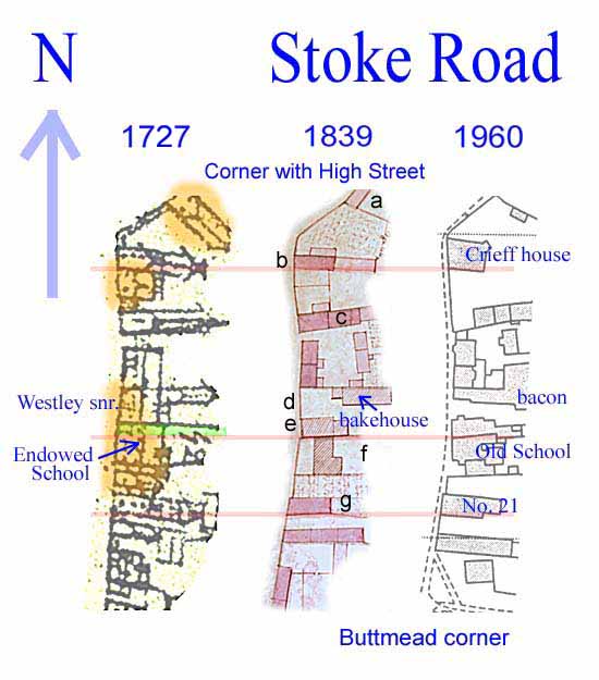 |
This panel shows just one side (the east side) of a section of the Stoke Road, formerly known as South Street, between the corner with the High Street and where Buttmead now joins. The plan is shown at three dates; 1727, 1839 (both Grafton surveys) and 1960. Some pink lines link the three plans at some readily identifiable features. The houses of most interest are labelled in sequence (a) through (g) on the 1839 plan and in the section below an account is given in that sequence. In the 1727 plan is shown, with orange areas, the buildings thought to be damaged by fire. In the 1839 plan the houses coloured darker pink are ones in occupation by tenants while the others are either barns or permanently unoccupied. |
|
|
(a) This house was actually on the High Street. In 1839 and right up to around 1960 there was a modest sized abode at this place. In c. 1930 it was occupied by a cobbler. What appears to be a long barn in the 1727 plan was evidently lost in the fire. The cobbler's house (see image 16-12a) was demolished in about 1960 and, remarkably, its residual gable can still be seen as part of a garden wall - a testament to the smallness of the house.
(c) The row of three modest abodes shown in 1839 appear to have survived the fire - which is surprising. The division nearest the Stoke Road was demolished in around 1930. The remaining divisions were merged in 2000 to form one cottage now called Crieff Cottage (see image 10-02). (d), (e) This is the site of the house of Joseph Westley snr. who was the chief baker with a bake-house behind his house. Both were possibly held freehold at the time - they certainly were by 1839 because the drawings are hatched in the plan. After the fire he rebuilt his house (see image 02-06) in a three-storey gable end-on configuration (e) to permit direct access to his bake-house (see image 11-03) from the road. He was fortunate in that the neighbouring building (f), the school, was also destroyed so that he could purchase, from either church or the Duke of Grafton, a narrow strip of land to make the configuration a success. That narrow strip is coloured green in the 1727 plan above. Westley paid £40 for the strip - money which used in the rebuilding of the school. (f) The school, endowed by the
Wake family in the 16th century but run and probably owned by the church
in 1839. It is hatched in brown and not pink to match the drawing
of the church building on the same map. Destroyed in 1798 and
rebuilt almost immediately, it is set back from the road by a few yards as shown in
the 1839 plan. The school was built right up against Westley's new
house. (g) Between buildings (f)
and (g) there appears to have been a small barn - now lost.
Judging from the boundaries which are currently recognised, this barn
would have probably been associated with building (g). |
||