|
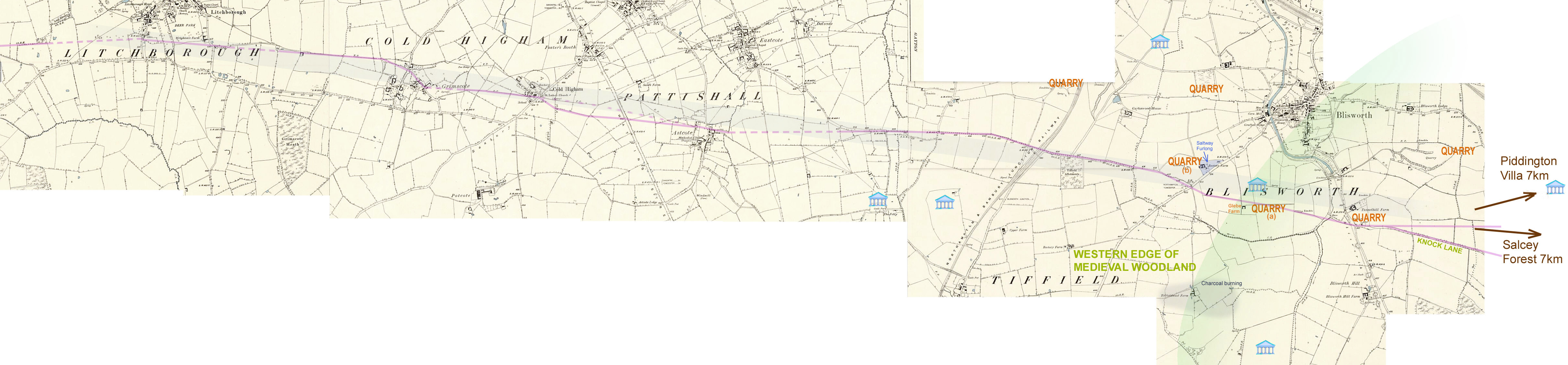
The Droitwich to Blisworth Saltway Tony Marsh Houghton (1929) and Hooke (1985) have discussed in detail the Droitwich salt production. Brine at a concentration 20 times that of sea water bubbles up from the ground in at least three places in or near Droitwich. The resulting salt, after boiling off the water is much purer than sea-salt and much cheaper (in fuel) to make. The use of salt as a condiment to enhance flavour was a luxury but its value in preserving meat and vegetables was vital for a community to live comfortably the whole year around. The salt production required labour, of course, and equipment made of both clay (available locally) and lead which had to be imported to fabricate evaporating pans. The main consumable was wood or charcoal and both were burnt at Droitwich. Manors not too distant from Droitwich habitually delivered wood by the cartload to pay for salt and this seems to have been organised along trackways now termed saltways - in the Anglo-Saxon era they were called "saelt straets". Some say that the term "straet" denotes a 'made-up' trackway with compressed stone much similar to the metalling practiced by the Romans. Droitwich must have been an affluent area - the pre-Roman equivalent of Lichtenstein or Monaco (whose economies depend on a peculiar single activity found in a particular location - ie. bespoke banking and gambling respectively). Houghton estimates Droitwich salt production at ~1000 tons pa in 1086; most of it sent to Manors or Vills occasionally as far away as a particular Royal household in Princes Risborough. According to Anglo-Saxon charter texts the payment rate was often one cartload of wood (1.0 to 1.5 tons ?) for one mitt (L. mittas) of salt. A mitt is thought to be around 2 Cwt though very few historians have committed themselves. The L. Mitta presumable is related to L. mittere (ie. to send) and therefore could mean anything and apparently is a term applied only to payments for salt - perhaps meant at the time "that which is sent (back, regularly) as a consignment". (see reference footnote). Saltway routes radiating from Droitwich run south, west, north-east and east. The south route parallels the use of the River Salwarpe, a tributary of the Severn, which would have either carried the product to Worcester or onto sea-going vessels capable of reaching the mainland coast of Europe. Such an export route is thought to be active in iron-age times and throughout the Roman period. The west route probably saw the trading for lead while the north-east route served the northern most parts of the Dubonni region (later the Hwicce region in Anglo-Saxon times). Interestingly it is thought by some that the north-east route was extended to the Lincolnshire coast at Saltfleet because of the frequent salt-related place-names found along that line (see the internet about Saltfleet). My theory is that such an extended route was not developed until Norman times when regional animosities were quelled. The sea-salt industry based at Saltfleet, which presumably derived some of its income revenue by export, would have wished to promote their status with a higher quality product. A similar argument might be voiced for the eastern route as some have realised that the compass heading for the route (seemingly east 7 or 8 degrees south) points to Harwich in Essex and the salt marshes just to the west of Harwich. To date, the idea of a long range route on this line enjoys just one reference - via the Ramblers Association c. 1978 as mentioned in the 2004 article on the saltway posted on this website, which this account supercedes. I have plotted the easterly route as far as the Salcey Forest in Northamptonshire. An imagination stretch would see it traverse by the market square in Olney (Buckinghamshire) but no suggestive lanes etc. on early OS maps seem to imply much of an extension beyond Olney. Houghton and Hooke researched the Anglo-Saxon and Norman charters (also the Domesday accountancy) and have been able to pinpoint saltway routes for most of their run. I have not done that yet, for Stoke Goldington, Ravenstone or Olney, but my work so far on the eastern projection is to be found on this website. Trackway from Droitwich The Roman road via Alcester to Stratford (Straet Ford) and onwards to Wellsbourne (Weles burne) is clear enough on both early and current OS maps. The route is littered with salt related place-names. Further east the next clue is Wormleighton. In the 956AD charter for Wormleighton the north boundary of the parish is described as the "boare saelt straet" and its line through to Priors Marston is clear enough. This village also lies on a stock drovers route and so has place-names such as Little London and "The Butcher's Arms" to substantiate that. It also lies at the boundary of the Hwicce kingdom with parts of Mercia. The next few miles are speculative with Preston Capes and Little Preston on the line. Northamptonshire amateur archeologists have discovered a couple of market meeting fields adjacent (on the south side) to the saltway running through Preston Capes. Somewhere in the vicinity of Preston Capes it is thought that a trackway also branches somewhat towards the north-east in order to serve Northampton. Then comes the alignment with Litchborough (a Lord of which imposed a toll on salt traders) and a remarkably linear alignment with footpaths through Grimscote and Cold Higham vectoring for Astcote on the opposite side of the Watling Street. As the line merges with the Gayton to Eastcote lane it acquires the name "Salt Lane" in some 1775 estate maps. The linear alignment continues right across Blisworth parish and includes part of the Knock Lane. The Litchborough to Knock Lane section is repeated here based on 1880 OS mapping - an improvement on the map employed elsewhere. The name 'Knock' is a placename for "near oak trees" ('at the oak' in OE was atten oke and the 'n' was subsequently joined to the next syllable to form noke, nock or knock). This map is available here on a second browser tab. Just click on the map to enlarge it. An interesting feature of the linear alignment is that it maintains a straight crossing over the Watling Street just south of Fosters Booth. This is reasonable based on the layout of 1885 footpaths (the dotted line crossing) but pseudo-Lidar data indicate a slightly cranked line (discussed below). In the vicinity of Grimscote there is much evidence of possible east-west path-braiding but few instances of intersections with north-south running paths - all quite unusual. The saltway also copies the vector alignment, depicted on the map as a light-shaded broad line, of 'east 7or 8 deg. south' similar to the radiation out of Droitwich. What should we deduce from these facts? That the saltway preceded the Watling Street? That the target for the saltway was identified at Droitwich and that it was essentially the Salcey Forest or some feature beyond? Perhaps we do not realise that the area west and north of the Salcey Forest may be rich in high status Roman Villas. For example the villas that we know (or suspect) were located at (1) Piddington, (2) Gayton Hill on the Blisworth-Gayton parish boundary, (3) embedded in Nunn Wood, (4) on the verge of the saltway quarry (near the present day Glebe Farm) and (5) at the Folly (?) west of Tiffield. Such an abundance of Roman customers for Droitwich salt may have resulted in the romanisation or extension of the saltway into the area and also resulted in its straightening over the Watling Street. Neat field subdivisions drawn out at the time of 'enclosure' tend to cloud the issue. The height above sea-level and the photogrammetric data from www.bluesky.com have been studied and the slightly cranked Watling Street crossing, as drawn in the map, is confirmed the most likely, running just south of a slight elevation in the road. This is on the interpretation of slight hollows in the fields (assumed formed by tramping) and even a slight hollow in the road; 2 ft over a distance of 400 yards along the road. The evidence is posted here for perusal. Roman villas are marked in the map. Though it may seem incredible, the Northamptonshire customers could have paid for the salt with cartloads of wood or charcoal from the wooded parts of Blisworth parish or from the extended Salcey Forest (before, of course, it was so named). This view is reasonable if straet really meant a mad-up road that could take wheeled traffic. A current view of the -worth ending to our village name denotes not just a place or an enclosure of houses but essentially one that was marginally located adjacent to waste or wooded grounds. Charcoal burning centres have been discovered north of Nunn wood, not far from Glebe farm. The saltway could well have served also for the long range transport of limestone but it is very unlikely that stone from Northamptonshire would be favoured since the western slopes of the Cotswolds are much more accessible to Droitwich (this is not to say that the salt Mansio would refuse payment in stone). In the parish of Blisworth a field was named "Saltway Furlong" (1727) but it does not border the saltway. Perhaps a different prominent field hedge was mistakenly taken as the saltway route by farmers c 16C. This is a tease because it points to a time when the saltway was no longer in use - was that really 16C? A curate in 1718 referred to a white-stone quarry by the saltway. I think he was referring to "a" but the tiny quarry at "b" (in the 19C), actually alongside Saltway Furlong, could perhaps have been bigger then - see the map. Houghton
F.T.S.
Trans Birmingham Arch. Soc. vol. 54 (1929), pp 1 - 17 Mitta: The rate of
exchange 2 Cwt of salt (ie. 1 mitt) being bought for a load of wood
occurs similarly among various charters, apparently. perhaps a mitt is
not a measure but merely a sent amount that reflected the
assessed value of that particular load in terms of not only weight but
also of its wetness and state of seasoning. Anyway, if the equivalence of 2
Cwt of salt for 1 ton of wood is about right in terms of the sale deal
then the Droitwich
salt masters would probably not use it all on account of its
thermal yield in order to dry to a mush the brine. |