|
Summary of Press-Cuttings on the New Bypass |
| Friday and Saturday, 21 & 22 January,
1983 An exhibition was held in the Village Hall in
Blisworth to show the plan of Blisworth and Milton Malsor bypass.
The line given was just as it is shown in the third map of our
historical view of village bypasses in that the existing new road
around Towcester is extended and widened to Tiffield and then aligned
with the Rothersthorpe Road services on the M1 where a set of new ramps
would be created to gain access to the motorway. The road would
then continue on to join Upton Way on the western fringe of Northampton
thus considerably enhancing the western access to the town. Much
of the necessary consultation with local interests (eg. farmers) had
been done and the plan appeared to have general approval.
15 July 1985 The £12M scheme was given government go ahead. Work was expected to start in the summer of 1989.
The arguments went on an on with much fuel derived from the evident fact that the original line had been picked from a list of one. Mr. Keith Barwell, now eminent in planning matters for the western part of the County, pitched in and favoured Route A according to a Chron. & Echo cutting Nov 5, 1987. Ministry officials said they would explore the detail of the new proposals in a new enquiry. July 1988 Government Inspector's report This ruled in favour of the original plan and thus pleased the majority. Several concessions were made in relation to screening for Blisworth Park and the quiet locality by the Northampton Arm (canal) and for the latter, the road would be shifted east by 21 metres. The inspector pointed out that an easterly route such as Route A will be needed as well - in due course. Indeed, the traffic through the village did not decrease by anywhere near the factor of ten suggested by one official when he eventually opened the new road and no doubt the stupidity of his prediction was indicated clearly in print in some 'backroom drawer'. After a short while there were calming measures needed in Blisworth which rather gave the political game away. |
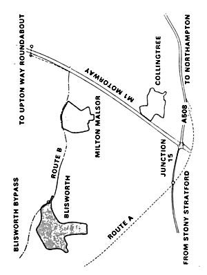 November 1987 A new plan emerges. The
proposal suggests connecting to the new road from Towcester but passing
to the east of Blisworth and Milton and joining the A45/A508 road into
Northampton (thus providing an easterly access to the town). The
road, labelled Route A, would evidently require a new bridge at junction
15 thus anticipating the massive bridge enlargement that was done c.
2004. Collingtree villagers were furious and the management of
Courteenhall Estates doubtless made their point that much farming land
would be lost with the Route A scheme. Interestingly the transport
departments original proposal was equated to Route B in the newspaper's
map yet this Route B is a cobbled line using some new and some old with
a 'last minute' turn left along the line of the M1 to find the junction
at the service station. This stuff was the work of amateurs.
A valid objection, though a minor one, was that some of the modest homes
on the Blisworth Park would have to be destroyed and rebuilt nearby and
this was why the Route B was suggested.
November 1987 A new plan emerges. The
proposal suggests connecting to the new road from Towcester but passing
to the east of Blisworth and Milton and joining the A45/A508 road into
Northampton (thus providing an easterly access to the town). The
road, labelled Route A, would evidently require a new bridge at junction
15 thus anticipating the massive bridge enlargement that was done c.
2004. Collingtree villagers were furious and the management of
Courteenhall Estates doubtless made their point that much farming land
would be lost with the Route A scheme. Interestingly the transport
departments original proposal was equated to Route B in the newspaper's
map yet this Route B is a cobbled line using some new and some old with
a 'last minute' turn left along the line of the M1 to find the junction
at the service station. This stuff was the work of amateurs.
A valid objection, though a minor one, was that some of the modest homes
on the Blisworth Park would have to be destroyed and rebuilt nearby and
this was why the Route B was suggested.