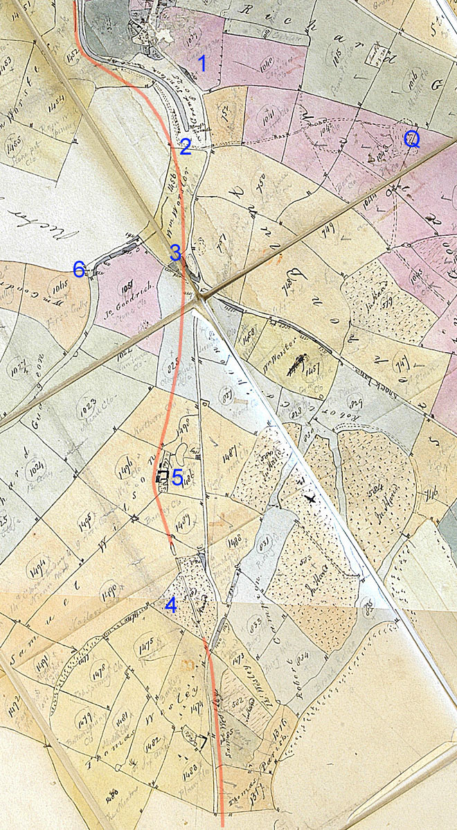
Early 19th century Agent's folding Map - South Fields
This undated map is kept in the N.R.O. under reference G4266. Notable is the absence of both a Hill Railway (dismantled after 1805 but its line is shown in pink below) and a mainline railway (for which land was being reserved in 1833). Notable also is the modest extent of the stone quarry (Q) to the east of the canal tunnel mouth (said to have been opened before 1820). These points allow the date when this map was drawn to be determined as c.1820. The map was probably carried by the notorious Grafton agent, John Roper, and used as a daily reference.
Features
are as follows:
1. The field that was once a warren (Coneygres) had not been subdivided
into allotments.
2. The railway (horse railway) from the quarry running down to the west
edge of the canal was in place.
3. The Stoke Road (toll road)
was widened at the intersection with Knock
lane and there were a number of modest paddocks of land nearby. These were a
residue of the accommodation needed for the horses powering the Stoke-Bruerne to
Blisworth hill railway the line of which is indicated by the pink line added
to the map. The oval shaped feature near the road junction
must have been the spoils heap on which a vent chimney was built (or later built).
4. Many fields were marked up with dots to convey that they were wooded and
labelled "In Hand", meaning that the Duke was holding land that was not
rented to anyone. In medieval times there were rights granted to villagers
to crop the woods for fence timber and firewood from an extensive 'common
land'. One of these fields, marked elsewhere as Berry
Hill,
adjacent to the Stoke Road, was intersected by a linear feature that was certain
to be a vestige of the hill railway. It seems there were more small paddocks
nearby.
5. The line of the hill railway does appear to pass behind a farm cluster, with
its adjacent field
labelled 'Home Close'. Blisworth Hill farm was therefore established by this
time, in the hands of a Samuel Wilson. The farm was established before
the inclosure award (1815) because Grafton rental records have Mr. Wilson as
tenant from 1806 to c.1834. The alignment of the railway is discussed in
the 'Revised Tunnel Story' available on this
website.
6. Roads were left uncoloured, white, and this applied to the
extension of Knock Lane to the west (see Saltway), joining Nunn Lane which
was
also classed as a common road, at that time, as far as the division in the streams.
It seems the Duke wanted to encourage horse owners, not associated with any
particular farm, to rent watered accommodation for their horses, even though the
intense call upon numbers of horses ceased in 1805 when the hill railway was
taken up.