|
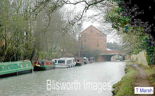
The Struggle to Retain the "Canal View" Previous title - One Hundred Years - from Wharf to Woodland and Back Again - What Next? Tony Marsh This note relates some of the history and recent troubles over a triangular sliver of land alongside the GU canal just south of Mill Bridge on the opposite side of the canal from the towpath. In the Blisworth Mill section of images is shown a 1914 picture of the mill and the bridge with the sliver of land to the left. It is about 40 yards wide by the bridge and tapers to near zero-width about 150 yards to the south where a field (known historically as The Park) begins. The sliver was once the Blisworth Public Wharf and was used for storing peoples' deliveries of wood, slates and timber. At the formation of British Waterways in 1948 the wharf became their property but later, when BW sought to develop it for housing, the Willow House family bought it from them, thus enlarging the garden around their house (location - see below). They were able to purchase all the wharf land immediately against the edge of the canal with an apparently confusing legal arrangement for access to the bank with BW (now the Canal and Rivers Trust). The area was allowed to become overgrown at times but in 1970 it was cleared to allow renewal of the canal edge palling. Sometime in the 1990s some of the land was sold in order that a second house could be built (Heligan House) adjacent to Willow House. A complicating feature of the area was that a foot path had become established which ran from the south through The Park and along a line to emerge at the Towcester Road. This path gave some indication of the limits of curtilage around the two houses but ran with 'garden', defined technically, on both of its sides. The path is totally obscured from view in the next photo, taken in 2005, because a rough growth of mainly ash trees had sprung up more or less everywhere. This photo appears as 06-14, for comparison, in the Blisworth Mill section beneath the 1914 photo mentioned in the first paragraph (photo 06-13).
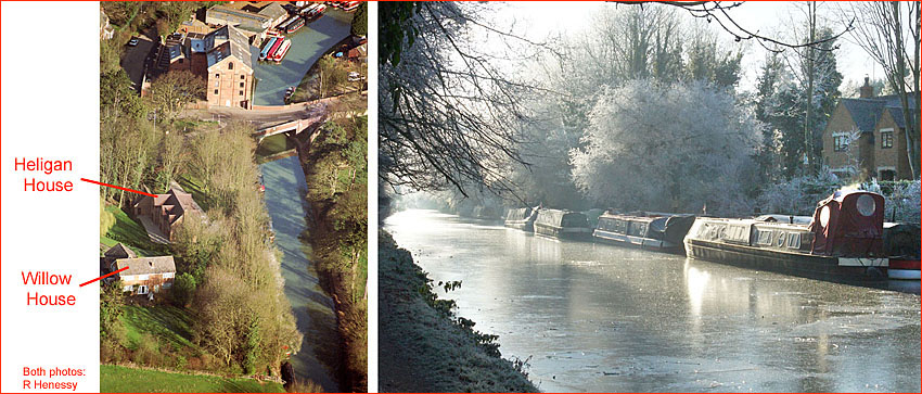
Shortly after the 2005 photo was taken the residents of Heligan House removed most trees and established a screen based mainly on laurel and have maintained the area well ever since, being some 70 yards out of a total 150 yard long sliver. In fact, Heligan House is well setback and the screen provides a rural feel to the vicinity of the bridge. The other 80 yards run of the land was neglected and allowed to become well wooded and this afforded charm to the run of the pathway that became increasingly attractive for ramblers, casual walkers and dog walkers especially at times when there were no frisky bullocks in The Park. The next pair of photos gives an impression of what effectively became "woodland" - both taken by Richard Henessy, the aerial shot in March 2000 and the other in the winter of 2012/2013. Note that in the latter, Heligan House is visible beyond the laurel screen. The gate for the path to communicate with The Park is just visible at the bottom of the aerial photo.
September 2013 to 23rd December 2013. This was the period set for local consultation over the plan to place into conservation the margins (including certain historical features) of the GU canal for its entire run through Northamptonshire. The next picture is based on a SNC map showing Mill Bridge (bridge no. 51) with the proposed conservation limits lined out with a red line. For the 150 yards of canal margin/gardens that are mentioned above, between the bridge and the marker P, the red line fairly well follows the line of the walked pathway, implying a will in the conservation plan to manage well that part of gardens between the path and the canal and also, probably, the path itself. The line also divides fairly well between the house curtilages and the remaining garden areas, for both houses. The latter should amount to pleasant screening with some measure of management assumed. However, in the Spring of 2014, the policy for dealing with the 'offside' margins of the canal was changed (see below).
18th December 2013 The resident of Willow House arranged to have the area of garden nearest to the canal clear-felled. No person other than the felling-contractors was involved in this action, this statement being necessary because initially it was rumoured that there had been a mix-up but later, the resident, by declaring publicly in a parish council meeting on 13th January that "one has a right to fell one's own trees", confirmed that the action was deliberate and not the product of a mix-up. The area that was treated that way is ringed with a yellow line. Villagers were then faced with a bare flat area adjacent to the canal rather than a short stretch of woodland path - that being something of a shock. The timing of the action to fell trees was within the conservation consultancy period and so the felling seemed very much like a dash before the finalisation of a conservation plan that would have been inconvenient to the resident. Many people wondered whether the resident, being a Parish Councillor, had violated the PC Code of Conduct. 6th. January 2014 At a parish council meeting, in which the resident was asked (being a councillor) to leave the room, a planning grant that had been deliberated over for perhaps the last 9 months was discussed in detail, sometimes heatedly. The crazy issue was that the same resident had succeeded in receiving full planning permission for a large house to be located at an adjacent point, shown by H in the last figure. The permission (recorded as S/2012/1057) prescribed conditions regarding the need for an arboreal screen both between the new house and the legally established pathway and further screening between the pathway and the edge of the canal. But that screening was to rely on a number of established trees to be retained for a period while the screen was expected to grow and become effective. The official position of the SNC (expressed later by R. Fallon, Development Manager) was then that the planning grant was no longer legally implementable but that the resident acted legally in felling the trees. What to do about the planning grant was the subject of meeting(s) between the resident and the planning enforcement officers. The village must simply await the planning decision which could well require a new application. The main point is that, although no one has done anything illegal, it is unfortunate that a village-wide appreciation of a little bit of woodland has been trumped by some selfish desire After all, the area possessed no trees early in the 20C and rather few in 1970. That is 40 years ago but that is long enough for many to forget and this is demonstrated in the 2010 Village Design Statement (prepared by SNC) in which the trees were classed as "important". 3rd February At a parish council meeting there were two interesting agenda items. One was to lodge a formal complaint against the resident, as a parish councillor, and the other was to suggest a way in which an improved basis could be established for that area proposed as conservation area (between the marker P in the last figure and the bridge). That way would be to compulsorily purchase the area and have the PC and the Canal Partnership as managers. The first agenda item was set aside with no discussion with the comment that the topic was up to the SNC to deal with. Discussion on the second was heavily mangled and fizzled out with no useful resolution but this is a common occurrence in meetings of the PC. If the proposal had been read out and if the councillor (aka. the resident) had been asked to leave the room then perhaps the benefits of carrying out the proposal could have been considered. The proposal was to designate the strip of land adjacent to the canal a public area for use of walkers and boaters and develop it towards a wooded leisure area managed by some combination of the PC and the Canal Partnership. One sad aspect of the village, however, is that the proposal contains its own seeds of destruction in that few can see how the PC and the progressive Canal Partnership could ever work together. Besides that, the proposal drew support from no-one and in a subsequent PC meeting it was declared inappropriate as the area was in private ownership and was "covered" in the conservation measures. June 2014 By now it is possible to update on a variety of issues, namely (a) the un-implementable planning consent? That remains so. (b). the legally walked line of the pathway, presently obliterated? The status of the pathway remains. (c). the final outline of the canal bank conservation? There has been a change to the policy, we are told; a one metre margin has been introduced for all offside areas beside the canal unless there is a distinct and relevant boundary or outline to which the conservation should abut (an inset map to be added). So the thoughts from the PC in the previous paragraph were wrong and "the resident" need not have felled any trees, an action which happened to neutralise the planning grant . . . This was a time for many adverse comments to be exchanged amongst villagers. The future of this strip of land is by no means determined and readers should expect updates. In fact, on Dec 3rd, 2014, the outline of the conservation was redefined as along the edge of the canal and extending in width up to the pathway so that over the area in which tree-felling was done about half of the area is now within conservation. North of that area the conservation line follows the red line in the mapping shown above. This is a pleasing result as a sensible screen between the canal and any housing development should be easy to secure, that is if someone wanted to take care of the area.
Finally: the most audacious of proposals, presumably pursuant mainly to profit June 2015 A special meeting, just before a parish council meeting, was called to discuss the latest plan of the SNC's to maybe allow development of the Willow House plot for five houses. The role of the abovementioned path would be affected by the plan. Details will be posted here when they are clearer. 17th December 2015 At this time the application for 5 houses was refused. There follows a passage written by the case officer for the rather audacious application which, in my opinion, nicely summarises the events of 2014 - 5. Some of this refers to events already reported here in previous paragraphs, so the reader could skip to section 5.2 - I have added some editorial comments. 4.1 Planning permission was granted for a detached dwelling and garage between Willow House and the canal in 2013, reference S/2012/1057/FUL. This permission (which is still live and does not expire until 6th October 2016) was subject to a landscaping scheme which retained and enhanced the tree belt along the canal. However, the permission has not yet been implemented and since the granting of permission many of these trees have been removed. The loss of these trees has meant that the permission in its current form cannot be lawfully implemented. [as explained above] 4.2 A previous proposal for a dwelling and garage in the same location as the application referred to above in paragraph 4.1 was refused in 2011 reference S/2011/0916/FUL on grounds of the size, scale, form, massing, layout and design of the proposal, which would be detrimental to the character and appearance of the area, the setting of the conservation area, the historic canal and the public right of way, the lack of an ecological survey and concerns relating to the relationship of the new dwelling to the existing dwelling Willow House. 4.3 Planning permission was granted in 2010 for a new dwelling to the other side of Willow House and behind number 1 Towcester Road reference S/2009/1143/FUL. This permission was subsequently extended until 6th October 2016 reference S/2013/0044/EXT. 5.2 [Lastly a proposal for . . ] redevelopment of the site with five dwellings. Following receipt of an amended proposal, the applicants agreed that the plans could be disclosed and discussed prior to a Parish Council meeting and comments invited. The Parish Council made no comments formally, but comments / objections were received from six [eventually 17] properties in the village following the meeting. Officers confirmed that their previous concerns and those raised as a result of the public consultation had been or could be addressed satisfactorily, for example through the imposition of conditions. There was considered to be no outstanding issues identified through the exercise which would be likely to warrant a refusal of the application, although as with all pre application discussions it was made clear that any pre-application advice was not binding on a subsequent formal application, which would be subject to further consultation with the local community and statutory consultees. The Parish Council objected on the following grounds: Five houses are too many for the site (over-development) Adverse impact on an area of scenic beauty as the canal enters the village Access road is too steep and too close to existing properties Contrary to Policy R1 as housing requirements have been met through other developments (Chapel Lane and development adjacent to Grafton House) The application should be refused due to local objections and non-compliance with Highways and Building Control requirements. The Design and Access Statement is inadequate and does not address the impact on the canal side conservation area The development does not reflect the character of the canal side setting or the form and massing of canal side buildings. The
SNC refusal was based upon:
The
proposed development of five dwellings by reason of their massing, scale,
height and prominence when viewed from the canal and public footpaths
would have a detrimental visual impact on the setting of the conservation
area and nearby listed buildings, contrary to Policies G3, EV1, EV10, EV11
and EV12 of the South Northamptonshire Local Plan, Policy BN5 of the West
Northamptonshire Joint Core Strategy and advice within the National
Planning Policy Framework, particularly Sections 7 (Requiring good design)
and 12 (Conserving and enhancing the historic environment). There is no point in showing the plans as the proposal was refused. One gets the impression that even within the SNC there was disagreement as to the extent that the development would have damaged the heritage of the south end of the village. There were 17 households who provided objection by letter or email and many professional groups (or semi-professional) that raised serious concerns. It does seem remarkable that months of discussions took place at the SNC with the originators of the proposal and there would have been a duty there, it is assumed, for the SNC to point out the disadvantages, ie. the likely objections, of the plan. Yet the application went ahead. It seems likely therefore that the originators will raise an appeal with the Bristol dept. One can only hope that a sympathetic treatment of this margin of the canal will eventually be found.
|