|
2013 Ground Subsidence in the field called Fisher Close
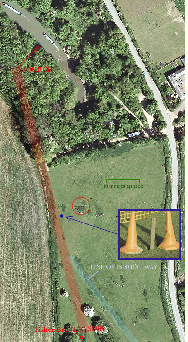
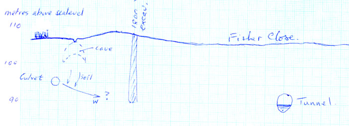
Jan 9, 2013 The hole was discovered by Mrs. Timmins on the 6th of January and the Canal and Rivers Trust were notified. C&RT duly fenced off the hole, noting that someone had bravely tested the hole depth by inserting a 12 foot long spar of wood into it. That is the piece of wood shown in the inset photo on the left. The location of the hole shown as a small blue dot is very near to the assumed line of the Fisher Brook culvert (pale red band) and to the location of a 1976 ground collapse that has been associated with early attempts to establish a line for the tunnel. There is further information on this collapse which included the loss of an electricity distribution pole at the approximate location ringed in red. (The historical account of the establishment of a successful line for the tunnel, written by Tony Marsh, is to be found here - but, for now, that background may well be irrelevant). The loss of soil leading to a cavitation which has worked its way up to the surface could be either due to a breach in the culvert or to some 1795-1800 exploratory excavation (labelled D in the history account) that has been damaged by the movement of rainwater over the past 200 years. The responsibility for exploring and dealing with this hazard has not been establish yet. The hole, probably made by a lucky horse, is centred on a public bridleway leading to Nunn Wood. It is estimated at 107m above sea level compared to the canal at 90m, the possible maximum depth of the old exploration also at 90m and the culvert at an estimated 95m. These numbers, in combination with the fact that the nearest horizontal approach of the tunnel is around 60 metres, suggest that the collapse is due to soil erosion around the culvert which may well be still intact. The crude cross-section drawing below shows what is in mind. The arrow labelled 'w' is an assumed flow of water which has caused progressive collapse above the culvert until a cavern reaches the surface. The tunnel is too far away to be directly affected but has problems of its own; disintegrating brickwork because of the ingress of water. Jan 19, 2013 The Canals and Rivers Trust have inspected the hole, enlarged the opening and determined that maybe 20 tonnes of rubble and soil will fill it in - for the sake of safety. They plan to do this by wheel-barrowing from a lorry backed into the cul-de-sac pathway. In the meantime a second hole has been found in the field. This is already fenced off and is beside the first ventilator shaft, not directly over the tunnel but close (a fair way to the south of the bottom edge of this map). This collapse is significant in that it suggests that there is considerable water-cored soil removal from either above/around the tunnel or around the ventilator shaft.
|