|
April 2009 - a mysterious hole appeared
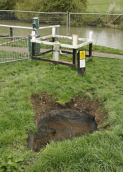
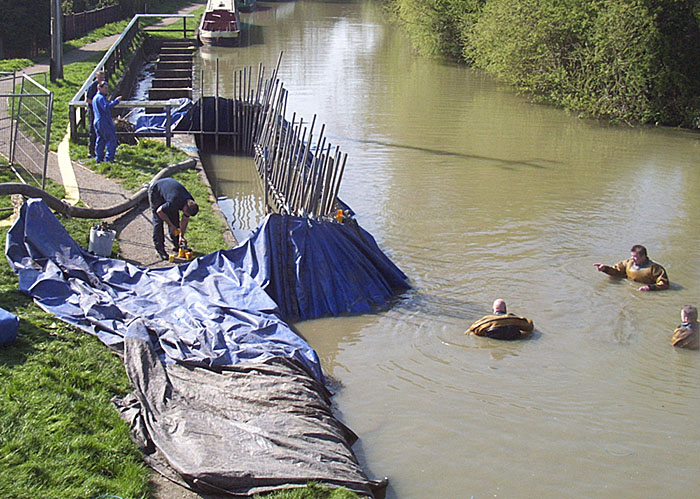
A passerby reported to British Waterways that a hole had appeared in the middle of a grassy triangle of Waterways land adjacent to Candle Bridge, quite near to the canal-side weir. It was immediately fenced off. In the following few days the hole enlarged itself and presented the inset view on 17th April. Water was seen trickling through at a depth of about 8 feet below the turf but the hole appeared to be much deeper than that. The substantial loss of soil, evidenced by the surface collapse, suggests a water path that would have generated a scouring action for quite a time. The obvious suggestion was that one of the culverts at a depth of 16 to 18 feet which collect water from the weir and the land-gate may well have collapsed allowing a path for washed soil to go into the nearby lake and onwards down to Swan Valley. The trickle at a much shallower depth, however, indicated that the land-gate or perhaps its brick box may be damaged too. By 24th April it was obvious to the BW staff that the wooden paddle in the land-gate had rotted to such an extent that it was serving little purpose and, anyway, to provide effective shut-off in times of drought it had been more or less completely filled with ash silt to seal it. In enquiries it was not possible to ascertain the origin of the trickle, being probably a lesser concern anyway. After all, this account is not supposed to serve as an engineering report. Early in the project, the canal was damned against the weir and gate area to remove the pressure of water from the canal. This was done in the time-honoured fashion as recorded b Paul Chapman whose photo of the operation is available.
An excavator was used to removed more soil so revealing an old collapsed dry culvert, seen above to the left, that was no doubt used to provide in the old days (before the weir was built in 1958) a means of flooding in emergencies the adjacent field called Pond Bank. The old culvert has been sealed off and is shown in light blue in the mock-up schematic on the right. The pale yellow circle represents the main hole as seen on 25th April and the smaller yellow circle indicates the very deep (12 feet and beyond) hole that is evident by the base of the ladder. Note there is an electric cable running down into this 'abyss' - someone had probably made an inspection. The idea of a breached culvert at roughly where there is a red cross seemed very plausible. The culverts, some of them thought to be at a depth of about 18 feet, are shown orange in the schematic. The dark blue line near all this excavation, both natural and human combined, is the high pressure natural gas conduit, 12 inches diameter, which steeply banks downwards to pass under the canal. At that stage it was not thought to be involved in this business. The fine black line passing close to the land-gate is a fibre-optic communications line running from London to Birmingham carrying a vast number of data channels. Luckily it had been only partially uncovered, in its plastic green pipe, at the side of the excavation, far enough out of harm's way. It is said the fine payable by BW is £1M per day if the link is damaged. True or false, the idea is enough to assure its longevity. Once the minor leakage had been sorted out the next phase was for a specialist sub-contractor to excavate a massive hole in order to gain safe access to the suspected damaged culvert. This was to take several days and, in the interests of safety, the hole was roughly backfilled with earth whilst the contractors were awaited.
PART II 20 July 2009 Contractors May Gurney and British Waterways convened a meeting at the refilled hole to discuss tactics. A machine moved in the next day and, by the next, it was clear that the trickle of water from either the paddle-box, the weir enclosure or the canal bank had not been addressed in the first part of the work. The depth of the new hole required that shuttering be installed, which was the cause of a slowed down rate of digging. The whole area was sealed off to all those not wearing high visibility clothing, 'toe-tector' boots and a hard hat.
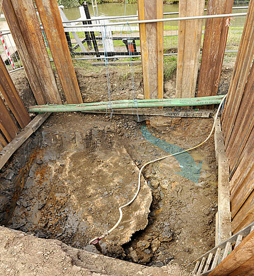 In the picture above, taken on the morning of July 24th, one can see the optic link in its green tubing and a trickle of water, arrowed, that seemed to proclaim itself the actual cause of the collapse of the ground level back in April and which was seen to disappear under a slab of concrete, heading for where exactly - another repair? That slab of concrete probably limited the scope of the first noticed collapse. It evidently covered a union of culverts from the land-gate and the weir. The concrete was barely 7 foot down and its edge can be seen in the shot taken in April, near the ladder. The team expected to dig no deeper than about 12 feet and believed that the oft-quoted 18 to 20 feet to be an exaggeration. The trickle was coming from the canal bank and would be 'dealt with'. The old dry culvert, by the way, was behind the shuttering on the right in this picture. The angle of the outline of the concrete aligned with the drop from the weir and the location of the manhole; thus the geometry of the culverts was being understood.
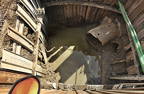
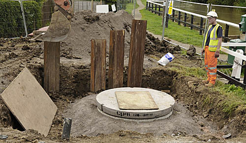
July 27, 2009 After a successful session cutting out the concrete and clearing masses of brickwork the team were happy to be left with two culvert stumps, one in concrete from the weir and the other of brick from the land-gate paddle. The next step was to use heavy ribbed plastic sleeves to join up the two outflows with the continuing concrete culvert which was peeping behind that slantwise board on the left. Then a liberal load of fast flowing concrete finished off the work and dispersed the effects of the minor leak from the bank. The ribbed sleeving was threaded right up to the weir so that no future reliance will be placed on the concrete culverts, this at the cost of halving the available diameter and throttling the maximum flow possible. Adding rings to the construction as it climbed up provided an inspection manhole as can be seen in the picture below taken on July 31 - these fellows worked fast. The continuing culvert was found to be in bad condition so another large hole was needed to replace that too.
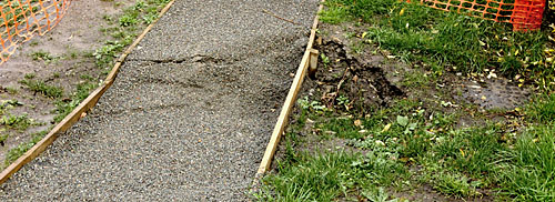
But was it
really done? November 20th and the nearby path has begun to
sink . . . |
 PART I 15th April 2009
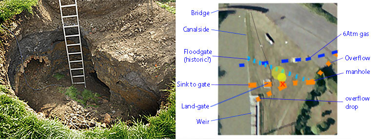
